McNair, Virginia facts for kids
Quick facts for kids
McNair, Virginia
|
|
|---|---|

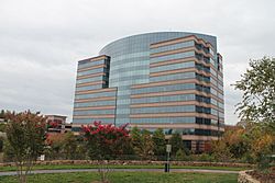
Buildings in Dulles Corner
|
|
| Country | United States |
| State | Virginia |
| County | Fairfax |
| Area | |
| • Total | 2.06 sq mi (5.33 km2) |
| • Land | 2.04 sq mi (5.29 km2) |
| • Water | 0.02 sq mi (0.05 km2) |
| Elevation | 340 ft (100 m) |
| Population
(2020)
|
|
| • Total | 21,598 |
| • Density | 10,577/sq mi (4,083.8/km2) |
| Time zone | UTC−5 (Eastern (EST)) |
| • Summer (DST) | UTC−4 (EDT) |
| ZIP code |
20171
|
| FIPS code | 51-48450 |
| GNIS feature ID | 2584871 |
McNair is a special kind of community in Fairfax County, Virginia, United States. It's called a census-designated place, which means it's a place with a name and borders, but it's not officially a city or town. McNair is located right next to the Washington Dulles International Airport.
In 2020, about 21,598 people lived in McNair. Many of these people live in a planned community called McNair Farms. There is also a school in the area named McNair Elementary. McNair is also home to the Dulles Corner Business Park. This business park has the main offices for big companies like Airbus Group, Inc. and Northrop Grumman Technical Services.
People Living in McNair
Population in 2020
According to the 2020 census, there were 21,598 people living in McNair. There were also 9,673 housing units. The area had about 10,484 people per square mile.
McNair is a very diverse place. Here's a look at the different groups of people living there:
- About 25% of the people were White.
- About 17% were African American.
- About 44% were Asian.
- About 5% were from other races.
- About 7% were from two or more races.
- About 14% of the population was Hispanic or Latino.
Many households in McNair are families. About 44% of households were married couples. The average family had about 3.30 people.
The average age of people in McNair was 30.9 years old. About 21% of the people were under 18. Only about 3.7% were 65 years old or older.
Many people in McNair speak a language other than English at home. About 57% of residents do. Also, about 44% of the people were born outside the United States.
The average income for a household in McNair was about $115,696 per year. For families, it was about $119,628. About 42% of adults in McNair have a college degree or higher.
Population in 2010
The population of McNair in the 2010 census was 17,513 people.
Where is McNair?
| Historical population | |||
|---|---|---|---|
| Census | Pop. | %± | |
| 2010 | 17,513 | — | |
| 2020 | 21,598 | 23.3% | |
| 2020 Census Data | |||
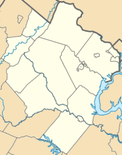
McNair is located in the northwest part of Fairfax County. It has several neighbors:
- To the northeast is the town of Herndon.
- To the east is Reston.
- To the south is Floris.
- To the northwest is Loudoun County.
Two important roads are near McNair. The Dulles Toll Road (Virginia State Route 267) runs along its northern edge. Virginia State Route 28 (Sully Road) forms part of its western border. You can get to downtown Washington, D.C. from McNair by taking the Dulles Toll Road and Interstate 66. It's about 25 miles away.
The total area of McNair is about 5.3 square kilometers (about 2 square miles). A very small part of this area, about 0.05 square kilometers, is water.
See also
 In Spanish: McNair (Virginia) para niños
 | William Lucy |
 | Charles Hayes |
 | Cleveland Robinson |


