McSherrystown, Pennsylvania facts for kids
Quick facts for kids
McSherrystown, Pennsylvania
|
||
|---|---|---|
|
Borough
|
||

McSherrystown, Pennsylvania
|
||
|
||

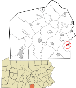
Location in Adams County and the U.S. state of Pennsylvania.
|
||
| Country | United States | |
| State | Pennsylvania | |
| County | Adams | |
| Settled | 1765 | |
| Incorporated | 1882 | |
| Government | ||
| • Type | Borough Council | |
| Area | ||
| • Total | 0.51 sq mi (1.33 km2) | |
| • Land | 0.51 sq mi (1.33 km2) | |
| • Water | 0.00 sq mi (0.00 km2) | |
| Elevation | 587 ft (179 m) | |
| Population
(2020)
|
||
| • Total | 3,077 | |
| • Density | 6,009.77/sq mi (2,321.57/km2) | |
| Time zone | UTC-5 (Eastern (EST)) | |
| • Summer (DST) | UTC-4 (EDT) | |
| Zip code |
17344
|
|
| Area code(s) | 717 | |
| FIPS code | 42-46376 | |
McSherrystown is a small town, called a borough, located in Adams County, Pennsylvania, United States. In 2020, about 3,077 people lived there.
This town was once home to the main office of Boyds Bears, a company famous for making teddy bears. It also had F.X. Smith & Sons, the oldest family-run cigar maker in the U.S., which started in 1863. Boyds Bears is no longer open, and the cigar company was sold in 2018.
History of McSherrystown
McSherrystown is one of the oldest towns in Adams County, being the fourth oldest. It was founded by Patrick McSherry (1725–1795). His family came from Newry in the northern part of Ireland.
In 1763, Patrick McSherry bought a large piece of land, about 300-acre (1.2 km2), from the Digges Family. He then started to divide this land into smaller lots, each about 5-acre (20,000 m2). The first official record of one of these lots being sold was on June 27, 1765.
At first, McSherry might have wanted these lots to be "outlots" for people living in nearby Hanover. These outlots would be places where they could keep their animals or get wood. However, the area quickly grew into a proper town. Patrick McSherry himself might never have lived in the town named after him. He was a tavern owner in Littlestown later on.
Geography and Location
McSherrystown is located at 39°48′15″N 77°1′9″W / 39.80417°N 77.01917°W. This is its exact spot on the map.
The United States Census Bureau says that the borough covers a total area of about 0.5 square miles (1.3 km2). All of this area is land, with no water.
Population Facts
| Historical population | |||
|---|---|---|---|
| Census | Pop. | %± | |
| 1850 | 206 | — | |
| 1860 | 280 | 35.9% | |
| 1870 | 291 | 3.9% | |
| 1880 | 439 | 50.9% | |
| 1890 | 1,020 | 132.3% | |
| 1900 | 1,490 | 46.1% | |
| 1910 | 1,724 | 15.7% | |
| 1920 | 1,800 | 4.4% | |
| 1930 | 2,050 | 13.9% | |
| 1940 | 2,128 | 3.8% | |
| 1950 | 2,510 | 18.0% | |
| 1960 | 2,839 | 13.1% | |
| 1970 | 2,773 | −2.3% | |
| 1980 | 2,764 | −0.3% | |
| 1990 | 2,769 | 0.2% | |
| 2000 | 2,691 | −2.8% | |
| 2010 | 3,038 | 12.9% | |
| 2020 | 3,077 | 1.3% | |
| Sources: | |||
The population of McSherrystown has changed over the years. In 2000, there were 2,691 people living in the borough. By 2020, the population had grown to 3,077 people.
Most people living in McSherrystown are White. There are also smaller groups of African American, Native American, Asian, and Hispanic or Latino residents.
In 2000, about 29% of homes had children under 18 living there. Many homes were married couples living together. About 15% of homes had someone living alone who was 65 years old or older. The average age of people in McSherrystown was 37 years old.
Education
Students in McSherrystown attend schools within the Conewago Valley School District.
See also
 In Spanish: McSherrystown para niños
 | Chris Smalls |
 | Fred Hampton |
 | Ralph Abernathy |


