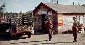
Meander River, Alberta facts for kids
Quick facts for kids
Meander River
|
|
|---|---|
|
Settlement
|
|
| Country | Canada |
| Province | Alberta |
| Region | Northern Alberta |
| Census division | No. 17 |
| Indian reserve | Upper Hay River 212 |
| Elevation | 328 m (1,076 ft) |
| Time zone | UTC−7 (MST) |
| • Summer (DST) | UTC−6 (MDT) |
| Highways | Alberta Highway 35 |
Meander River is a small community located in northern Alberta, Canada. It's part of the Upper Hay River 212 area, which belongs to the Dene Tha' Band. This community sits right on Alberta Highway 35, also known as the Mackenzie Highway. It's an important stop for travelers driving between Alberta and the Northwest Territories.
Location and Climate
Meander River is found on the banks of the Hay River. It sits about 328 meters (1,076 feet) above sea level. Because it's so far north, the area has a very cold climate. The plant hardiness zone is 0B, which means only very tough plants can grow here.
Jobs and Community Life
Many people from Meander River travel to High Level, a town about 70 kilometers (43 miles) south, for work. Other jobs are available right in the community. These include working at the Upper Hay River School, which was built in 1996, and at the Dene Tha' Band office.
Local Services
The community has good internet access thanks to fiber optic cables from Alberta SuperNet. You can also listen to two FM radio stations: CFWE 89.9 FM and CIAM 92.3 FM. For education, there is one school called Upper Hay River School. Medical care is provided at the Meander River Health Station.
Fun Activities
There are many ways to have fun in Meander River, especially outdoors!
- Join a recreational hockey or ball hockey league.
- Play in a recreational volleyball league.
- Go cross-country skiing in the winter.
- Enjoy snowmobiling when there's snow.
- Try canoeing on the river.
- Go hunting or fishing.
Religion
The community has one church, which is the Catholic Mission.
 | DeHart Hubbard |
 | Wilma Rudolph |
 | Jesse Owens |
 | Jackie Joyner-Kersee |
 | Major Taylor |


