Meauwataka, Michigan facts for kids
Quick facts for kids
Meauwataka, Michigan
|
|
|---|---|

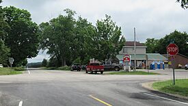
Intersection of N. 29 Road and E. 24 Road in Meauwataka
|
|
| Country | |
| State | |
| County | Wexford |
| Township | Colfax |
| Settled | 1867 |
| Elevation | 1,368 ft (417 m) |
| Time zone | UTC-5 (Eastern (EST)) |
| • Summer (DST) | UTC-4 (EDT) |
| ZIP code(s) |
49601 (Cadillac)
|
| Area code(s) | 231 |
| GNIS feature ID | 632062 |
Meauwataka (pronounced MEE-ə-wə-TAH-kə) is a small, unnamed community in the U.S. state of Michigan. It is not a city or town with its own government. Instead, it is an unincorporated community located within Colfax Township in Wexford County. Meauwataka is part of Northern Michigan and is near the city of Cadillac.
History of Meauwataka
The name Meauwataka comes from the Potawatomi language. It means "halfway." This is because the community is located almost exactly halfway between Lake Mitchell and the Manistee River.
People first settled here in 1867. Back then, it was known as Dayhuff Lake, named after a nearby lake. A post office opened in Meauwataka in 1872. It served the community for many years, finally closing in 1952.

All content from Kiddle encyclopedia articles (including the article images and facts) can be freely used under Attribution-ShareAlike license, unless stated otherwise. Cite this article:
Meauwataka, Michigan Facts for Kids. Kiddle Encyclopedia.


