
Mehoopany Creek facts for kids

Mehoopany Creek is a cool stream in Pennsylvania, USA. It flows for about 26.8 miles (43.1 km) through Sullivan and Wyoming counties before joining the big Susquehanna River. This creek is super important because it's known for its clean, cold water, which is perfect for fish. It's also a special place for rare plants!
Contents
- Where Does Mehoopany Creek Start and Go?
- How Healthy is Mehoopany Creek's Water?
- What is the Land Around Mehoopany Creek Like?
- What is the Mehoopany Creek Watershed?
- How Has Mehoopany Creek Been Used Over Time?
- What Kinds of Animals and Plants Live Here?
- What Can You Do for Fun at Mehoopany Creek?
- Images for kids
Where Does Mehoopany Creek Start and Go?
Mehoopany Creek begins its journey in a spot called Splashdam Pond, located in Colley Township. From there, it flows north, then turns east, leaving Sullivan County pretty quickly.
Once it enters Forkston Township in Wyoming County, the creek heads east into a valley. It winds around, picking up smaller streams like Bellas Brook and South Brook. It passes by Short Mountain and then turns north for a few miles, where it meets White Creek. The valley gets a bit flatter, and it connects with North Fork Mehoopany Creek. Finally, it turns northeast and enters Mehoopany Township. The creek then meanders (winds back and forth) for several miles until it joins the Susquehanna River near a community called North Mehoopany.
What Are the Main Tributaries of Mehoopany Creek?
Mehoopany Creek has several smaller streams, called tributaries, that flow into it. The most important ones are Stony Brook and North Fork Mehoopany Creek. North Fork Mehoopany Creek joins the main creek about 6.26 miles (10.07 km) before it reaches the Susquehanna River. Stony Brook joins about 12.20 miles (19.63 km) upstream from the mouth.
How Healthy is Mehoopany Creek's Water?
The amount of rain in the Mehoopany Creek area usually ranges from 35 to 45 inches (89 to 114 cm) each year. In early spring, the water in Mehoopany Creek can be a bit acidic.
What is the Land Around Mehoopany Creek Like?
The land around Mehoopany Creek is quite "rough and hilly," especially in its upper parts. There are many steep hills that can be 900 to 1000 feet (270 to 300 m) high! The creek itself winds and turns a lot. Closer to where it meets the Susquehanna River, the creek has flat areas called floodplains, which can sometimes get covered with water during heavy rains.
The creek flows over different types of rocks, mainly shale and sandstone. In some places, Mehoopany Creek has "dangerously situated strainers" (obstacles like fallen trees) and exciting rapids, which are fast-moving sections of water.
What is the Mehoopany Creek Watershed?
The entire area that drains water into Mehoopany Creek is called its watershed, and it covers about 123 square miles (319 km²). This watershed stretches across three counties: Sullivan, Wyoming, and Bradford.
Most of the land in the watershed is covered by forests. In the upper parts of the creek, you can find Lakes and swamps. One notable lake is Grant Lake, which is about 68.8 acres big.
Some communities are located within the Mehoopany Creek watershed. In the early 1900s, the biggest towns were Mehoopany, Ricketts, and Forkston. Major roads like Pennsylvania Route 87 also run through the area.
How Has Mehoopany Creek Been Used Over Time?
People have used Mehoopany Creek for different things throughout history. In the early 1900s, farming was common in the watershed. The creek's strong water flow also powered many mills, which were used to grind grain or saw wood. The Lehigh Valley Railroad even had tracks in the upper part of the watershed. Logging, which is cutting down trees, has also happened near the creek's starting point.
What Kinds of Animals and Plants Live Here?
Mehoopany Creek is known as a high-quality coldwater fishery, especially in Sullivan County. This means its cold, clean water is perfect for fish. About 9.8 miles (15.8 km) of the creek are stocked with fish, but you can also find native trout living there naturally, especially in Stony Brook.
The very beginning of Mehoopany Creek is a super important wetland area. It's listed as one of the top priority sites in Sullivan County because it's home to several rare plant species that are hard to find elsewhere in Pennsylvania. Even though it has rare plants, the wetlands are mostly covered by blueberry plants.
What Can You Do for Fun at Mehoopany Creek?
Mehoopany Creek is a great place for canoeing! It's suitable for both beginners and those with a bit more experience. The lower parts of the creek are easier to canoe on than the upper parts, and the scenery along the creek is described as "good." The American Whitewater Association says the creek's difficulty for canoeing ranges from easy (I) to moderate (III) when the water flow is normal.
The creek also flows through Pennsylvania State Game Lands in many areas. These are public lands where people can enjoy outdoor activities like hunting, fishing, and hiking.
Images for kids
-
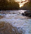
Mehoopany Creek in Forkston Township, Wyoming County, Pennsylvania
