Mellen, Wisconsin facts for kids
Quick facts for kids
Mellen, Wisconsin
|
|
|---|---|

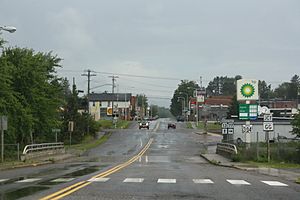
Looking north in downtown Mellen
|
|

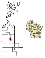
Location of Mellen in Ashland County, Wisconsin.
|
|
| Country | |
| State | |
| County | Ashland |
| Settled | 1886 |
| Incorporated | March 22, 1907 |
| Area | |
| • Total | 1.86 sq mi (4.82 km2) |
| • Land | 1.86 sq mi (4.82 km2) |
| • Water | 0.00 sq mi (0.00 km2) |
| Elevation | 1,250 ft (380 m) |
| Population
(2020)
|
|
| • Total | 698 |
| • Estimate
(2023)
|
689 |
| • Density | 375.27/sq mi (144.81/km2) |
| Time zone | UTC-6 (Central (CST)) |
| • Summer (DST) | UTC-5 (CDT) |
| ZIP code |
54546
|
| Area code(s) | 715 & 534 |
| FIPS code | 55-50700 |
| GNIS feature ID | 1579857 |
Mellen is a small city in Ashland County, located in the state of Wisconsin in the United States. It was first settled in 1886 and officially became a city on March 22, 1907. According to the 2020 census, about 698 people live in Mellen.
Contents
Fun Things to Do in Mellen
One exciting place to visit near Mellen is Copper Falls State Park. It is just north of the city and offers beautiful natural sights.
Mellen's Location and Size
Mellen is located at 46°19′27″N 90°39′33″W / 46.32417°N 90.65917°W. It sits right along the Bad River. The city covers a total area of about 1.87 square miles (4.82 square kilometers). All of this area is land, with no large bodies of water inside the city limits.
Mellen's Weather
Mellen experiences a climate with distinct seasons. Summers are generally warm, while winters are cold and snowy. The city gets a good amount of rain throughout the year, with more precipitation in the warmer months. Heavy snowfall is common during winter.
People Living in Mellen
Mellen has seen changes in its population over the years. In 1910, there were 1,833 people living here. By 2020, the population was 698. In 2023, it was estimated to be around 689 people.
Who Lives in Mellen?
Based on the census from 2010, there were 731 people living in Mellen. Most residents, about 97.1%, were White. A small number of people were Native American or from other backgrounds. About 1.6% of the population identified as Hispanic or Latino.
The average age of people in Mellen in 2010 was 46.5 years old. About 20.7% of the residents were under 18. Also, 22.2% of the people were 65 years old or older.
Getting Around Mellen
Bus services are available in Mellen. They are provided by Bay Area Rural Transit.
Important People from Mellen
Many people who have lived in Mellen have gone on to do important things. Some have become politicians, serving in the Wisconsin State Assembly or even the United States House of Representatives. These include:
- Robert F. Barabe, a politician who served in the Wisconsin State Assembly.
- D. E. Bowe, another politician from the Wisconsin State Assembly.
- Bernard E. Gehrmann, who also served in the Wisconsin State Assembly.
- Bernard J. Gehrmann, a politician who served in both the U.S. House of Representatives and the Wisconsin Legislature.
Images for kids
-
Joan of Arc Willow
See also
 In Spanish: Mellen (Wisconsin) para niños
 | William M. Jackson |
 | Juan E. Gilbert |
 | Neil deGrasse Tyson |


