
Copper Falls State Park facts for kids
Quick facts for kids Copper Falls State Park |
|
|---|---|

Copper Falls
|
|

Copper Falls State Park
Location in Wisconsin

Copper Falls State Park
Location in the United States
|
|
| Location | Ashland, Wisconsin, United States |
| Area | 3,068 acres (12.42 km2) |
| Established | 1929 |
| Governing body | Wisconsin Department of Natural Resources |
| Website | Copper Falls State Park |
|
Copper Falls State Park
|
|
| Location | WI 169, 1.8 mi. NE of Mellen |
| Nearest city | Morse, Wisconsin |
| Built | 1929–1953 |
| Architect | Bernard Herber Knobla, J.C. Steiro |
| NRHP reference No. | 05001425 |
| Added to NRHP | December 16, 2005 |
Copper Falls State Park is a beautiful state park in Wisconsin. It covers about 3,068-acre (1,242 ha) of land. The park is famous for its amazing waterfalls and deep gorges. These are formed by the Bad River and its smaller stream, Tylers Forks.
Long ago, Native Americans from the Old Copper Culture lived here. Later, European settlers also came to mine copper in the area. The park was officially created in 1929. Many of its cool features, like buildings and trails, were built by special groups called the Civilian Conservation Corps and the Works Progress Administration. In 2005, the park was added to the National Register of Historic Places because of its important history.
Contents
Fun Things to Do at Copper Falls
Copper Falls State Park offers many activities for visitors. You can explore nature, go fishing, or enjoy a picnic. It's a great place for outdoor adventures.
Loon Lake Activities
- Swimming and Boating: Loon Lake is a great spot for swimming. You can also enjoy kayaking, canoeing, and boating. Only electric motors are allowed on the lake.
- Fishing Fun: If you love to fish, you can try catching trout in the Bad River and Tylers Forks.
Trails for Exploring
- Hiking and Biking: The park has about 17 miles (27 km) of trails. These trails are perfect for hiking and biking.
- Winter Sports: In winter, some trails are used for cross-country skiing and snowshoeing.
- North Country Trail: A part of the North Country National Scenic Trail runs through the park. This is a very long trail that goes through many states!
Camping Adventures
- Campsites: The park has 24 campsites where you can set up your tent or park your RV. Some sites have electric hookups.
- Camper Cabin: There's also a special camper cabin. It's designed to be easy to use for people with disabilities.
A Look Back: Park History
Copper Falls Park is located near a long ridge of rock formations. This area is called the Penokee-Gogebic Mineral Range. It stretches for 80 miles from Ashland County.
Early Mining Days
- Copper Mining: People mined copper in this area during the American Civil War. In the 1880s, there were two copper mines near where a log footbridge is now.
- Ruggles' Efforts: Around 1900, a man named Wells M. Ruggles tried to dig for copper. His mine shaft kept filling with water from the Bad River. So, he used dynamite to change the river's path!
Logging and Land Changes
- Forests Cut Down: From 1886 to 1920, many trees were cut down in Ashland County. This left a lot of stumps and empty land.
- Farming Challenges: Some of this land was sold to immigrants for farming. But the soil was not good for many crops. Also, the summers in northern Wisconsin are short. Because of this, many farms were left empty by the 1920s and 1930s. This made the land more likely to have fires and erosion.
Creating the Park
- Land Purchase: In 1907, Ruggles sold 130 acres around the falls to investors. Local people worked to make the area better for visitors.
- Building Bridges: In 1922, WWI veterans Nick Stilin and Henry Kritz built three swinging footbridges. These bridges helped people see the waterfalls better.
- State Takes Over: The state of Wisconsin bought 520 acres in 1929. They bought more land in 1935.
The CCC and WPA Projects
- Civilian Conservation Corps: In 1935, a group called the Civilian Conservation Corps (CCC) came to Copper Falls. These were 164 young men, mostly from Illinois. They were skilled workers like masons and carpenters.
- Park Development: For 23 months, the CCC built many things in the park. They built the recreational lodge, stone fireplaces, benches, and tables. They also built an observation tower and laid water and electric lines. They cleared areas for parking, camping, and trails.
- Works Progress Administration: After the CCC left in 1937, another program called the WPA continued the work. The WPA hired local unemployed men for public projects. They improved trails, built a playground, and finished other park buildings. Their work continued until 1941.
Floods and Repairs
- River Damage: The Bad River flooded on August 30, 1941. This flood damaged the bathing pond, bathhouse, and two bridges.
- More Flooding: Another flood on June 24, 1946, destroyed the swimming pond and bathhouse. It also wrecked a set of wooden steps.
Images for kids
-
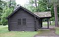
Cabin
-
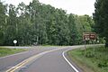
Sign
-
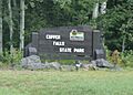
Entrance sign
-
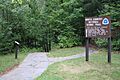
North Country National Scenic Trail
-
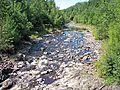
The Bad River in Copper Falls State Park


