Mendocino Pass facts for kids
Quick facts for kids Mendocino Pass |
|
|---|---|
 |
|
| Elevation | 4,984 ft (1,519 m) |
| Traversed by | |
| Location | Glenn County, California, U.S. |
| Range | Northern Coast Ranges |
| Coordinates | 39°47′40″N 122°56′06″W / 39.7943216°N 122.9350041°W |
| Topo map | USGS Mendocino Pass |
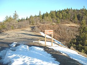
Mendocino Pass is a natural pathway through the Northern Coast Ranges in California. It's like a low spot or gap between mountains. This pass is located in the far northwest corner of Glenn County. It sits high up, about 4,984 feet above sea level.
At Mendocino Pass, two dirt roads meet. One of these is US Forest Highway 7. This dirt road connects two separate parts of State Route 162. Because of heavy snow, the pass and its dirt roads are closed during the winter months.
What is a Mountain Pass?
A mountain pass is a low point or a natural opening in a mountain range. Think of it as a natural path that allows people to travel from one side of the mountains to the other. Passes are often the easiest and safest ways to cross tall mountains. They have been used for thousands of years by travelers, traders, and explorers.
Where is Mendocino Pass?
Mendocino Pass is found in the California Coast Ranges. These are a group of mountains that run along the Pacific Ocean in California. The pass is specifically located in Glenn County, California, which is in the northern part of the state. Its high elevation means it's quite a climb to get there!
Roads and Travel
The main road that goes through Mendocino Pass is US Forest Highway 7. This road is not paved; it's a dirt road. It helps connect different parts of California State Route 162. State Route 162 is a longer highway in California.
Traveling through Mendocino Pass can be challenging, especially in winter. Heavy snowfall makes the roads unsafe and impassable. Because of this, the pass is closed to traffic during the colder months of the year.
 | Ernest Everett Just |
 | Mary Jackson |
 | Emmett Chappelle |
 | Marie Maynard Daly |

