Mers El Kébir facts for kids
Quick facts for kids
Mers El Kébir
بلدية المرسى الكبير
Baladiyya al-Marsā al-Kabīr
|
|
|---|---|
|
Municipality
|
|
| Commune of Mers El Kébir | |

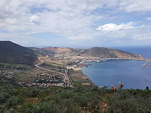
View of Mers El Kébir
|
|

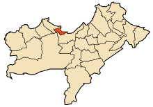
Location of Mers El Kébir within Oran Province
|
|
| Country | |
| Province | Oran |
| District | Aïn El Turk |
| Area | |
| • Total | 10.98 km2 (4.24 sq mi) |
| Elevation | 0 m (0 ft) |
| Population
(2006)
|
|
| • Total | 16,950 |
| • Density | 1,543.7/km2 (3,998.2/sq mi) |
| Time zone | UTC+01 (CET) |
| Postal code |
31310
|
| ONS code | 3115 |
Mers El Kébir (Arabic: المرسى الكبير, romanized: al-Marsā al-Kabīr, lit. 'The Great Harbor' ) is a port city located on the Mediterranean Sea in northwest Algeria. It is very close to the city of Oran in Oran Province. This historic port is famous for an important event during the Second World War when the British navy attacked the French fleet there in 1940.
Contents
History of Mers El Kébir
Mers El Kébir has a long and interesting history. It was first a Roman port called Portus Divinus.
Early Control and Pirate Activity
In the 12th century, Mers El Kébir became a naval base for the Almohad empire. Later, in the 13th century, it was controlled by the rulers of the Kingdom of Tlemcen. Around 1492, the port became a busy center for pirates.
Different groups fought to control this important port. The Ottoman Turks, the Portuguese, and the Spanish all wanted it. The Spanish, who called it Mazalquivir, finally captured it in 1505. This was led by Cardinal Cisneros.
Spanish and Ottoman Rule
Mazalquivir became the base for the Spanish to capture nearby Oran in 1509. The Spanish held both cities until 1708. At that time, they were forced out by Bey Mustapha Ben Youssef.
However, the Spanish returned in 1732. Their army, led by the Duke of Montemar, won a battle and took back Oran and Mazalquivir. The Spanish kept control of both cities until 1792. Then, King Carlos IV of Spain sold them to the Dey of Algiers after a long siege.
French Occupation
The French took control of Mers El Kébir in 1830. They renamed it Saint André de Mers-el-Kébir. In 1868, they improved the port and built a lighthouse. Sadly, this lighthouse was destroyed during World War II.
Mers El Kébir in World War II
Mers El Kébir played a key role in World War II.
Attack on the French Fleet (1940)
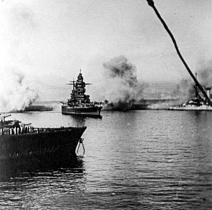
After Nazi Germany defeated France in 1940, some French warships were docked in the port of Mers El Kébir. On July 3, 1940, the British Royal Navy's Force H, led by Vice Admiral Sir James Somerville, attacked the French fleet.
The British attacked because the French refused to agree to demands that would prevent their navy from joining forces with Nazi Germany. The attack was successful, but it made many people in France very angry at Britain. However, it showed the United States that Britain was determined to fight against Nazi Germany. During the attack, Admiral Somerville sank or heavily damaged three French ships, and about 1,300 sailors lost their lives.
Mers El Kébir After World War II
After World War II, France continued to use its naval base at Mers El Kébir. They developed the base a lot in 1953. It was even used to help with atomic tests.
The Évian Accords were agreements signed on March 18, 1962. These agreements recognized Algeria's independence from France. They allowed France to keep its naval base at Mers El Kébir for 15 years. However, France decided to leave the base earlier, withdrawing five years later in 1967.
Today, the Algerian National Navy uses the naval base at Mers El Kébir. It is home to a large number of their ships, including their Kilo-class submarine fleet and other frigates and corvettes.
See also
 In Spanish: Mazalquivir para niños
Images for kids
 | Sharif Bey |
 | Hale Woodruff |
 | Richmond Barthé |
 | Purvis Young |


