
Mersey River (Tasmania) facts for kids
Quick facts for kids Mersey River |
|
|---|---|

Mersey River near Latrobe
|
|
| Lua error in Module:Location_map at line 420: attempt to index field 'wikibase' (a nil value). | |
| Country | Australia |
| State | Tasmania |
| Physical characteristics | |
| Main source | Lake Meston Walls of Jerusalem National Park 1,022 m (3,353 ft) 41°53′56″S 146°13′40″E / 41.89889°S 146.22778°E |
| River mouth | Devonport |
| Length | 147 km (91 mi) |
| Basin features | |
| Bridges | Victoria Bridge, Devonport |
| Inland ports | Port of Devonport |

The Mersey River is an important river on the north-west coast of Tasmania, Australia. It flows into Bass Strait. The city of Devonport is located right at the river's mouth.
Contents
Where the Mersey River Begins and Flows
The Mersey River starts high up in the mountains. Its source is Lake Meston. This lake is found within the beautiful Walls of Jerusalem National Park.
The River's Journey Through Lakes
As the Mersey River flows, it passes through several lakes.
- After Lake Meston, the river flows into Lake Youd.
- Further downstream, the Mersey River reaches Lake Rowallan. Here, you can find the Rowallan Power Station. This station uses the river's water to create hydro-electric power.
- Next, the Mersey flows into Lake Parangana. This lake also gets water from the Fisher River.
- From Lake Parangana, some water is sent through tunnels to the Lemonthyme Power Station. This water then flows into Lake Cethana.
- The Mersey River continues its journey from Lake Parangana. It passes through the Parangana Power Station.
Tributaries Joining the Mersey
Many smaller streams and creeks join the Mersey River along its path. These are called tributaries.
- Lees Creek is one tributary that flows into lakes like Lake Orion before joining the Mersey.
- Other creeks like Feather Creek and Campfire Creek also add to the river's flow.
- The Dasher River and the Minnow River are also important tributaries.
- Near the end of its journey, creeks like Kings Creek and Ballahoo Creek join the Mersey.
The River's End at Devonport
The Mersey River eventually flows under the Victoria Bridge. It then passes through the busy Port of Devonport and the city itself. Finally, the Mersey River empties into Bass Strait.
Major Flood in 2016
In the winter of 2016, the Mersey River experienced a very large flood. This happened because of a lot of heavy rain across Tasmania. The flood caused a lot of damage.
- Bridges and other buildings near the river were damaged.
- The river banks were washed away in many places.
- Many trees were pulled out of the ground. These trees then got stuck in narrow parts of the river, forming huge piles of logs.
- People who enjoy kayaking on the river had to carry their kayaks around these logjams to continue their journey.
Fun Activities on the Mersey River
The Mersey River is a great place for many outdoor activities.
Fishing

The Mersey River is very popular for fishing. You can catch different types of trout here, including brown and rainbow trout.
Regattas and Events
The river hosts exciting events throughout the year.
- Every March, the Devonport Regatta takes place. This event includes thrilling power boat races. There are also fun activities like the Trans Mersey Swim and woodchopping competitions.
- On Australia Day (January 26th), Latrobe holds its Henley-on-Mersey Regatta. This event features woodchopping, Ferret racing, a Triathlon, and even fun contests like cherry spitting and gum boot throwing.
Water Sports
The Mersey River is also a fantastic spot for water sports.
- Many people enjoy whitewater rafting on the river's exciting rapids.
- Water skiing is another popular activity that takes place on the Mersey.
Images for kids
-
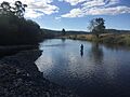
Mersey River near Latrobe
-
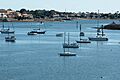
The Estuary of the Mersey River at Devonport.
-
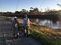
Anglers along the Mersey
See also
 In Spanish: Río Mersey (Tasmania) para niños
