Mescalitan Island facts for kids

Mescalitan Island was once a special island shaped like a flat-topped hill, called a mesa. It was located about 10 miles west of Santa Barbara, California, in the United States. The island was near where the Goleta Slough met the Pacific Ocean.
Contents
History of Mescalitan Island
The Chumash People
Long ago, Mescalitan Island was home to a village called Helo. This village belonged to the Chumash people, who were Native Americans living in the area. Early Spanish records say that a visitor named Juan Crespi saw a large village there. He noted that Helo had at least 100 houses. Between 600 and 800 people lived on the island at that time.
European Explorers Arrive
The first European explorer to visit the Goleta area was Juan Rodriguez Cabrillo. He was a Portuguese navigator who arrived on October 15, 1542. Back then, the Goleta Slough was very deep and wide. Big ships could easily sail into it.
Later, a Spanish ship called a 'goleta' reportedly sank in the lagoon. Because of this, the area became known as Goleta. Cabrillo was injured during a trip north and later passed away. Some stories say he was buried on San Miguel Island. However, the local Chumash people believed he was buried on Mescalitan Island.
Mescalitan Island was a very important landmark in the Goleta Slough area. But over time, things changed. In the 1860s, many floods and winter storms caused the slough to fill up with dirt and sand.
The Island is Leveled
In 1941, the U.S. Army Corps of Engineers made a big change to Mescalitan Island. They leveled most of the island. They used the dirt and land from the island to create a flat area for a Navy airport. This airport later became part of Marine Corps Air Station Santa Barbara in 1942. A few years after that, it became the Santa Barbara Municipal Airport.
Mescalitan Island Today
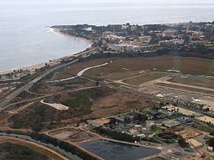
Today, the Goleta Sanitary Water Resource Recovery District is located where the island once stood. This is a facility that helps clean water.
You can also see a mural that shows Mescalitan Island. It is on the side of the Santa Cruz Market on Hollister Avenue in old town Goleta.
Location of Mescalitan Island
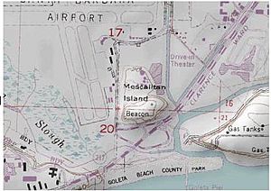
The place where Mescalitan Island used to be is in southern Santa Barbara County, California. Its exact location is 34 degrees, 25 minutes, 16 seconds North latitude. It is also at 119 degrees, 50 minutes West longitude. Mescalitan Island is shown in the middle of the Goleta USGS topographic map.
 | Tommie Smith |
 | Simone Manuel |
 | Shani Davis |
 | Simone Biles |
 | Alice Coachman |


