Mexican Hat, Utah facts for kids
Quick facts for kids
Mexican Hat, Utah
|
|
|---|---|

Mexican Hat
|
|

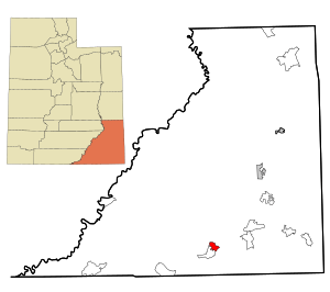
Location in San Juan County and the state of Utah.
|
|
| Country | United States |
| State | Utah |
| County | San Juan |
| Area | |
| • Total | 8.5 sq mi (22 km2) |
| • Land | 8.2 sq mi (21 km2) |
| • Water | 0.3 sq mi (0.8 km2) |
| Elevation | 4,244 ft (1,294 m) |
| Population
(2010)
|
|
| • Total | 31 |
| • Density | 3.8/sq mi (1.5/km2) |
| Time zone | UTC-7 (Mountain (MST)) |
| • Summer (DST) | UTC-6 (MDT) |
| ZIP code |
84531
|
| Area code(s) | 435 |
| FIPS code | 49-49380 |
| GNIS feature ID | 1430248 |
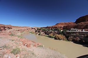
Mexican Hat is a small community in Utah, United States. It is a census-designated place (CDP), which means it's a special area defined by the census bureau. The town sits along the San Juan River. It's located on the northern edge of the Navajo Nation in south-central San Juan County. In 2010, only 31 people lived there.
History of Mexican Hat
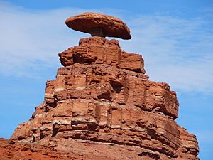
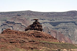
The name "Mexican Hat" comes from a very interesting rock formation. This rock looks like a giant sombrero, which is a type of hat. It's located on the northeast side of the town. The rock is about 60 feet (18 meters) wide and 12 feet (3.7 meters) thick. People who like rock climbing can find two routes to climb this unique "Hat." Mexican Hat is often mentioned on lists of places with unusual names.
In 2016, a bridge in Mexican Hat was given a new name. The U.S. Route 163 bridge crosses the San Juan River on the town's southern border. It was renamed the "Jason R. Workman Memorial Bridge." This was done to honor Jason R. Workman, who was a member of SEAL Team Six. He sadly passed away while serving in Afghanistan on August 6, 2011. Workman had graduated from the nearby San Juan High School in 1997.
Geography and Location
Mexican Hat is located on U.S. Route 163. It's just 3 miles (4.8 km) south of where U.S. Route 163 meets State Route 261. The town is also right outside the northern border of both the Navajo Nation and Monument Valley.
Several interesting places are close to Mexican Hat:
- Goosenecks State Park is about 9 miles (14 km) to the west-northwest.
- Alhambra Rock is about 6 miles (9.7 km) to the west-southwest.
- The Valley of the Gods is located north of Mexican Hat on U.S. 163.
The total area of Mexican Hat is about 8.5 square miles (22 square kilometers). Most of this area, about 8.2 square miles (21 square kilometers), is land. The remaining 0.3 square miles (0.78 square kilometers) is water.
Climate
Mexican Hat has a semi-arid climate. This means it's usually dry, but not a desert. It gets some rain, but not a lot. On climate maps, this type of climate is often called "BSk."
Population and People
| Historical population | |||
|---|---|---|---|
| Census | Pop. | %± | |
| 1990 | 259 | — | |
| 2000 | 88 | −66.0% | |
| 2010 | 31 | −64.8% | |
| source: | |||
According to the census from 2010, there were 31 people living in Mexican Hat. These people lived in 17 different homes. The population density was about 3.8 people per square mile (1.5 people per square kilometer). This means there weren't many people living in a large area.
Most of the people in Mexican Hat were White (90.3%). About 9.7% of the population was Native American.
When looking at the ages of the people in 2010:
- About 6.4% were under 15 years old.
- No residents were between 15 and 24 years old.
- About 25.8% were between 25 and 44 years old.
- About 25.9% were between 45 and 64 years old.
- About 42% were 65 years old or older.
The average age of people in Mexican Hat was 54.5 years old. This shows that the population in Mexican Hat tends to be older.
See also
 In Spanish: Mexican Hat (Utah) para niños
 | Misty Copeland |
 | Raven Wilkinson |
 | Debra Austin |
 | Aesha Ash |


