Middlefield, New York facts for kids
Quick facts for kids
Middlefield, New York
|
|
|---|---|

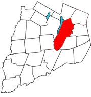
Otsego County map with the Town of Middlefield in Red
|
|
| Country | United States |
| State | New York |
| County | Otsego |
| Area | |
| • Total | 63.71 sq mi (165.00 km2) |
| • Land | 63.33 sq mi (164.03 km2) |
| • Water | 0.37 sq mi (0.96 km2) |
| Elevation | 1,709 ft (521 m) |
| Population
(2010)
|
|
| • Total | 2,114 |
| • Estimate
(2016)
|
2,029 |
| • Density | 32.04/sq mi (12.37/km2) |
| Time zone | UTC-5 (Eastern (EST)) |
| • Summer (DST) | UTC-4 (EDT) |
| FIPS code | 36-46910 |
| GNIS feature ID | 0979214 |
Middlefield is a town located in Otsego County, New York, United States. In 2010, about 2,114 people lived there.
The Town of Middlefield is in the northeastern part of Otsego County. It is the largest town in the county when measured by its total area.
Contents
A Look Back: Middlefield's History
People from Scotland and Ireland first settled in this area around 1755. The very first settlements were made close to what is now Middlefield village. The town itself was officially formed in 1797 from a nearby area called Cherry Valley.
A factory called the Phoenix cotton mill started operating in 1815. It made cotton products. Later, in 1866, it changed to become a wool mill, making items from wool.
Two special places in Middlefield are listed on the National Register of Historic Places. These are the Middlefield Hamlet Historic District and the Benjamin D. North House. Being on this list means they are important historical sites.
Where is Middlefield? (Geography)
Middlefield covers a total area of about 65.9 square miles (170.7 square kilometers). Most of this area, about 64.4 square miles (166.8 square kilometers), is land. The rest, about 1.5 square miles (3.9 square kilometers), is water.
New York State Route 166 is a road that follows the Cherry Valley Creek through the southern part of the town. Both Cherry Valley Creek and Red Creek flow through Middlefield. These creeks eventually flow into the larger Susquehanna River.
The western part of Middlefield is right next to Otsego Lake. This is a large, beautiful lake in New York.
Who Lives in Middlefield? (Population)
| Historical population | |||
|---|---|---|---|
| Census | Pop. | %± | |
| 1820 | 2,579 | — | |
| 1830 | 3,323 | 28.8% | |
| 1840 | 3,319 | −0.1% | |
| 1850 | 3,131 | −5.7% | |
| 1860 | 2,825 | −9.8% | |
| 1870 | 2,868 | 1.5% | |
| 1880 | 2,726 | −5.0% | |
| 1890 | 2,200 | −19.3% | |
| 1900 | 2,100 | −4.5% | |
| 1910 | 1,949 | −7.2% | |
| 1920 | 1,547 | −20.6% | |
| 1930 | 1,504 | −2.8% | |
| 1940 | 1,592 | 5.9% | |
| 1950 | 1,481 | −7.0% | |
| 1960 | 1,376 | −7.1% | |
| 1970 | 1,457 | 5.9% | |
| 1980 | 1,870 | 28.3% | |
| 1990 | 2,231 | 19.3% | |
| 2000 | 2,249 | 0.8% | |
| 2010 | 2,114 | −6.0% | |
| 2016 (est.) | 2,029 | −4.0% | |
| U.S. Decennial Census | |||
In the year 2000, there were 2,249 people living in Middlefield. These people lived in 792 households, and 564 of those were families. The population density was about 34.9 people per square mile.
About 32.6% of the households had children under 18 living with them. Most households, 58.8%, were married couples living together. About 24.1% of all households were made up of people living alone.
The population was spread out by age. About 22.5% of the people were under 18 years old. About 22.4% were 65 years of age or older. The average age in Middlefield was 43 years old.
Places to Explore in Middlefield
Middlefield has several smaller communities and interesting spots:
- Bowerstown – This is a small hamlet located southeast of Cooperstown. You can find it on County Route 52.
- Cooperstown – The eastern part of the famous Village of Cooperstown is actually within Middlefield.
- Cooperstown-Westville Airport (K23) – An airport is located in the southern part of Middlefield.
- Cornish Hill – This is a raised area, or elevation, found southeast of Cooperstown.
- Eggleston Hill – Another elevation, located south of Cornish Hill.
- Glimmerglass State Park – A small section of this state park touches the northern border of the town, near County Highway 31.
- Hyde Bay – Part of this bay, which is on Otsego Lake, is in the northwestern area of Middlefield.
- Lentsville – A hamlet in the northern part of the town. It's south of Middlefield Center on County Road 33.
- Middlefield – This hamlet was once known as Clarksville. It's on County Road 35, on the eastern edge of the town. This hamlet was recognized as a historic place in 1985.
- Middlefield Center – A small group of houses located on County Route 33.
- Moss Pond – A lake located south-southeast of Phoenix Mills.
- Murphy Hill – An elevation found east of Cooperstown.
- Phoenix Mills – A hamlet located in the southern part of the town.
- Westville – This hamlet is on County Route 35, south of the Middlefield hamlet.
- Whig Corners – A hamlet northeast of Cooperstown, located on County Route 33.
See also
 In Spanish: Middlefield (Nueva York) para niños

