
Middlesex Fells Reservation Parkways facts for kids
Quick facts for kids |
|
|
Middlesex Fells Reservation Parkways
|
|

East Border Road in Malden
|
|

Location in Massachusetts

Location in the United States
|
|
| Location | Malden, Medford, Melrose, Stoneham, and Winchester in Massachusetts |
|---|---|
| Built | 1896 |
| Architect | Eliot, Charles; Olmsted Brothers |
| MPS | Metropolitan Park System of Greater Boston MPS |
| NRHP reference No. | 02001749 |
| Added to NRHP | February 4, 2003 |
The Middlesex Fells Reservation Parkways are special roads that go through and around the Middlesex Fells Reservation. This is a big state park located just north of Boston, Massachusetts. The park covers parts of Malden, Medford, Melrose, Stoneham, and Winchester. These roads are so important that they are listed on the National Register of Historic Places. This means they are recognized as important historical places in the United States.
The Middlesex Fells Reservation is one of the oldest and largest parks in the Metropolitan Park System of Greater Boston. The park was created in 1894. A group called The Trustees of Reservations gave about 1,112 acres (450 ha) of land to the Metropolitan Parks Commission. This commission later became the Massachusetts Department of Conservation and Recreation (DCR). By 1897, the park had grown to about 3,000 acres (1,214 ha).
Some roads already existed in the area and became part of the park's internal roads. The idea for the roads around the park came from a landscape designer named Charles Eliot. He helped save the Fells area. Eliot believed that these border roads should clearly show where the park begins and ends. They also gave people living nearby nice views of the park.
Contents
Exploring the Border Parkways
These roads generally have two lanes and are about 30 feet (9.1 m) wide. They sometimes pass through small parts of the park itself. We'll describe them starting from the south and moving clockwise around the park.
South Border Road
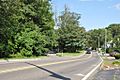
South Border Road starts at Roosevelt Circle in Medford. This is a big intersection with Interstate 93 and Fellsway West. The road then runs along the southwest edge of the park. It goes northwest into Winchester and ends where it meets Highland Avenue and the Mystic Valley Parkway. Highland Avenue is a local road that borders the park to the west. The Mystic Valley Parkway connects the Fells to other DCR lands near the Mystic River Reservation.
Along South Border Road, you'll find small parking areas. These are mostly unpaved and let you get to the park's trails. A small part of this road goes inside the park because more land was bought later.
Hillcrest Parkway
Hillcrest Parkway is a U-shaped road in Winchester. Both ends of this road connect to Highland Avenue. It's one of the shorter parkways, about 4,000 feet (1,219 m) long. On one side of the road are houses built in the early 1900s. The park is on the other side. This road is only 24 feet (7.3 m) wide and doesn't have painted lines. It's not usually used for through traffic. Near its northern end, you can see a nice view of the North Reservoir.
South Street and Pond Street
South Street starts in Stoneham at Main Street. It runs east-southeast for about 0.25 miles (0.40 km) until it joins Pond Street. Along this part of the road, there's a grassy area with parking. It offers great views of Spot Pond. A different part of Pond Street goes north towards Stoneham's town center. The parkway section of Pond Street goes south into the park, following the eastern shore of Spot Pond.
Where Pond Street meets Woodland Road, it turns east. It then connects to Fellsway East and the Lynn Fells Parkway. The Lynn Fells Parkway connects the Fells to the Breakheart Reservation. The section of Pond Street along the pond is four lanes wide. It has a wide grassy area in the middle separating the traffic going in opposite directions.
Fellsway East
The northern part of Fellsway East runs either inside or along the edge of the Fells. From its meeting point with Pond Street in Stoneham, it goes south. It passes a small triangular intersection with Ravine Road. Soon after, it enters Melrose. After passing Washington Street, it goes through a very wooded part of the park. Finally, it reaches its connection with East Border Road in Malden. This road continues south as a connecting parkway.
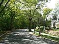
East Border Road
East Border Road starts west from Summer Street in Malden. It goes through the intersection with Fellsway East. It runs along the heavily wooded southern side of the park. It ends at Highland Avenue, a local street in Medford. A short part of Highland Avenue goes north along the park border to a circular intersection with Woodland Road and Elm Street. This short part of Highland Avenue is not part of the historic listing.
Elm Street
Elm Street continues to follow the southern side of the park. It goes west from the junction with Woodland Road and East Border Road. It runs west until it meets Fellsway West. There's a parking area along this road that gives you access to Wright's Pond.
Fellsway West
Fellsway West is partly a border road and partly an internal road within the park. The border section connects Elm Street to Roosevelt Circle. North of this connection, only about 2,000 feet (610 m) of the road are part of the original parkway design. This is because Interstate 93 was built nearby and changed a lot of the road. The internal part of Fellsway West helps you get to some central areas of the reservation.
Exploring the Interior Parkways
These parkways are located completely inside the Middlesex Fells Reservation. We'll describe them roughly from east to west.
Ravine Road
Ravine Road is a fairly short road, about 3,000 feet (914 m) long. It connects Woodland Road in the west to Fellsway East. The road is only 28 feet (8.5 m) wide. It is surrounded by thick forest on both sides. The ravine it's named after has Spot Pond Brook. The brook is just to the north, but you can't see it from the road.
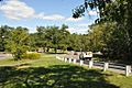
Woodland Road
Woodland Road is one of the two main north-south parkways that go through the reservation. It's a four-lane road with a grassy area in the middle for most of its length. It runs south from South Street in Stoneham. It ends at a junction with Elm Street and Highland Avenue in Medford. Its main intersections are designed as small circles. Woodland Road gives you access to the Spot Pond area, the visitor center at the John Bottume House, and the Metropolitan District Commission Pumping House.
Fellsway West (Interior Section)
The part of Fellsway West that is inside the reservation goes north from Elm Street in Medford. It ends at a junction with North Border Road and South Street in Stoneham. This section has been changed a lot because of the nearby Interstate 93. Because of these changes, most of this part of the parkway is not included in the National Register listing. This parkway helps you get to the Lower Sheepfold lot, which is a parking area located in the center of the reservation.
Images for kids
-
Hillcrest Parkway in Winchester
-
Woodland Road near Ravine Road and the John Bottume House in Stoneham
-
South Border Road in Medford


