Lynn Fells Parkway facts for kids

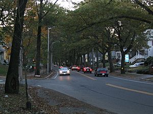
Lynn Fells Parkway near Warwick Road in Melrose
|
|
| Maintained by | Department of Conservation and Recreation |
|---|---|
| Length | 4.0 mi (6.4 km) |
| Location | Greater Boston, Massachusetts |
| West end | Fellsway East in Stoneham |
| East end | |
|
Lynn Fells Parkway, Metropolitan Park System of Greater Boston
|
|
| Lua error in Module:Location_map at line 420: attempt to index field 'wikibase' (a nil value). | |
| Location | Melrose, Saugus, and Stoneham, Massachusetts |
| MPS | Metropolitan Park System of Greater Boston MPS |
| NRHP reference No. | 03000380 |
| Added to NRHP | May 9, 2003 |
The Lynn Fells Parkway is a special kind of road called a parkway in the Greater Boston area of Massachusetts, United States. It's maintained by the Massachusetts Department of Conservation and Recreation. This road stretches about 4 miles (6.4 km) long.
It starts at Fellsway East in Stoneham. From there, it goes eastward through Melrose. The parkway finishes in Saugus at US Route 1. The Lynn Fells Parkway helps connect two cool nature spots: the Middlesex Fells Reservation and Breakheart Reservation.
Building the Parkway
The idea for the Lynn Fells Parkway came up in 1897. It was planned as part of a big network of parkways around Boston. The famous Olmsted Brothers landscape design firm first suggested it. They wanted the parkway to connect the Middlesex Fells to the Lynn Woods Reservation in Lynn. However, this full plan was never completed.
The first part of the parkway was built between 1906 and 1908. This section went from the Stoneham-Melrose border to Main Street in Melrose. One part was very hard to build because it was on swampy land near Ell Pond Park. That difficult section wasn't finished until 1911.
Building stopped for a while because there wasn't enough money. Construction started again in 1929. This time, they worked on extending the parkway to US Route 1. There were also plans to continue the parkway all the way to Lynn Woods. They even bought land and started preparing it from Route 1 to Walnut Street. Today, some of that land is used for the interchange between Route 1 and the parkway.
Historic Recognition
The part of the parkway in Melrose and Saugus was added to the National Register of Historic Places on May 9, 2003. This is a special list of places important to history. It was listed along with other roads that are part of the Metropolitan Park System of Greater Boston.
Besides the road itself, other things helped it get on this list. These include the many trees that create a shade canopy over much of the road. Also, a bridge built in 1930 that carries railroad tracks over the road in Melrose is considered important. This bridge is located between Vinton and Tremont Streets.
Where the Parkway Connects
The Lynn Fells Parkway connects with other important roads. Here are its main intersections:
| County | Location | Mile | Roads intersected | Notes | |
|---|---|---|---|---|---|
| Middlesex | Stoneham | 0.0 | 0.0 | This is where the parkway begins. It continues south as Fellsway East. | |
| Essex | Saugus | 3.8 | 6.1 | This is an interchange, meaning roads connect without stopping. | |
| 4.0 | 6.4 | ||||
| 1.000 mi = 1.609 km; 1.000 km = 0.621 mi | |||||
 | Tommie Smith |
 | Simone Manuel |
 | Shani Davis |
 | Simone Biles |
 | Alice Coachman |

