Milberger, Kansas facts for kids
Quick facts for kids
Milberger, Kansas
|
|
|---|---|

|
|
| Country | United States |
| State | Kansas |
| County | Russell |
| Founded | 1884 |
| Elevation | 1,857 ft (566 m) |
| Time zone | UTC-6 (CST) |
| • Summer (DST) | UTC-5 (CDT) |
| ZIP code |
67665
|
| Area code | 620 |
| FIPS code | 20-46475 |
| GNIS ID | 475411 |
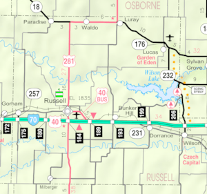
Milberger is a small community in Russell County, Kansas, USA. It's not a city or town with its own government, but a group of homes and businesses. You can find it about 10.5 miles south of Russell, Kansas and 3.5 miles west of U.S. Route 281. It is located on Michaelis Road.
Contents
A Look Back: Milberger's History
Milberger was started in 1884 by people called Volga Germans. These families came from a region near the Volga River in Russia. Most of them were Lutheran Christians. They built several churches in the area. Many of these churches closed by 1980. Milberger also had a small post office. It was open from 1903 to 1911. Today, Milberger is a quiet place. It has a farm equipment store, a church, a bar, and a few houses.
Where is Milberger?
Milberger is located in the Smoky Hills region of the Great Plains. It sits on the west side of Landon Creek. This is about 4.5 miles south of the Smoky Hill River. The community is about 3.5 miles west of U.S. Route 281. It is also 10.5 miles south of Interstate 70. The county seat, Russell, Kansas, is about 12 miles north of Milberger.
What's in Milberger?
Milberger has a few businesses and buildings.
- Radke Implement: This is a dealership that sells farm equipment.
Learning in Milberger
Children in Milberger attend schools in the Russell County USD 407 public school district. This district serves the community and surrounding areas.
Getting Around Milberger
Milberger is located where two county roads meet. 182nd Street is a paved road that runs north and south. Michaelis Road is an unpaved road that runs east and west.
 | William Lucy |
 | Charles Hayes |
 | Cleveland Robinson |


