Mill Creek (Mono Lake) facts for kids
Quick facts for kids Mill Creek |
|
|---|---|

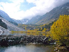
Beaver dam on Mill Creek in Lundy Canyon
|
|
| Country | United States |
| State | California |
| Region | Mono and Tuolumne County |
| City | Mono City |
| Physical characteristics | |
| Main source | Lake Cascade Sierra Nevada 10,400 ft (3,200 m) 37°59′06″N 119°18′29″W / 37.9849°N 119.3081°W |
| River mouth | Mono Lake Mono City, California 6,378 ft (1,944 m) 38°00′58″N 119°07′42″W / 38.01611°N 119.12833°W |
| Length | 14.5 mi (23.3 km) |
| Basin features | |
| Basin size | 24.7 sq mi (64 km2) |
| Tributaries |
|
Mill Creek is a stream that flows for about 14.5-mile-long (23.3 km). It starts high up in the Sierra Nevada Mountains in California. The creek then flows east into Mono Lake. Along its journey, Mill Creek passes through beautiful places like Lundy Canyon and Lundy Lake. It also goes by Mono City, California before reaching Mono Lake.
Where the Water Comes From
Most of the water in Mill Creek comes from melting snow. About 81% of the water that flows each year comes from snow that melts between April and September. The rest of the water, about 19%, comes from the ground during the drier months, from October to March.
A Look Back in Time
In 1880, a man named William O. Lundy got permission to use the timber (wood) in this area. The small town near the May Lundy Mine was first called Mill Creek. Early in the 1900s, people started using the creek's water to make electricity. This is called hydroelectric power.
In 1911, the Lundy Project was finished. A dam was built that made Lundy Lake 37 feet deeper. This allowed the Southern Sierra Power Company to generate more electricity from the water.
Animals and Nature
There's a discussion about whether beavers were originally from Mill Creek and the Mono Basin area. In the 1950s, the California Department of Fish and Game brought beavers to Mill Creek.
Now, the beaver population is doing very well. They live above Lundy Reservoir and throughout Lundy Canyon. In recent years, these beavers have even started moving to other nearby creeks. These include Wilson Creek, DeChambeau Creek, and Lee Vining Creek.
Exploring the Area
You can explore the area by hiking the Lundy Canyon trail. This trail takes you past several pretty waterfalls. It leads up to Lake Helen. After that, the trail becomes a bit easier as it goes into the "20 Lakes Basin."
From there, you can find trails that go around Saddlebag Lake. You can also hike towards North Peak and Mount Conness. These mountains are right on the edge of Yosemite National Park.
 | James Van Der Zee |
 | Alma Thomas |
 | Ellis Wilson |
 | Margaret Taylor-Burroughs |

