
Millersburg, Ohio facts for kids
Quick facts for kids
Millersburg, Ohio
|
|
|---|---|
|
Village
|
|

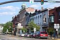
Downtown Millersburg
|
|

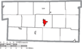
Location of Millersburg in Holmes County
|
|

Millersburg, Ohio
Location in Ohio

Millersburg, Ohio
Location in the United States
|
|
| Country | United States |
| State | Ohio |
| County | Holmes |
| Township | Hardy |
| Area | |
| • Total | 2.54 sq mi (6.59 km2) |
| • Land | 2.54 sq mi (6.57 km2) |
| • Water | 0.01 sq mi (0.02 km2) |
| Elevation | 899 ft (274 m) |
| Population
(2020)
|
|
| • Total | 3,151 |
| • Density | 1,242.51/sq mi (479.78/km2) |
| Time zone | UTC-5 (Eastern (EST)) |
| • Summer (DST) | UTC-4 (EDT) |
| ZIP code |
44654
|
| Area code(s) | 330 |
| FIPS code | 39-50372 |
| GNIS feature ID | 1057849 |
| Website | http://www.millersburgohio.com/ |
Millersburg is a small village in the state of Ohio, United States. It is the main town, or county seat, of Holmes County, Ohio. Millersburg is about 66 miles (106 km) south of Cleveland.
This village is located in the middle of Ohio's Amish Country. Because of this, many people visit Millersburg each year. The population of Millersburg was 3,151 people in the year 2020. The Holmes County Airport is also nearby, serving the area.
Contents
History of Millersburg
Early Beginnings: Old Town (1815)
The first part of Millersburg was planned in November 1815. Two men, Adam Johnson and Charles Miller, from Coshocton County, designed this area. It was known as "Old Town."
The first person to settle in Old Town was Thomas Haskins. He moved there in the spring of 1819. Soon after, in 1820, James Withrow built a building that became a tavern.
First School and Sermons
A small cabin was built in late 1820 to be the town's first school. Joseph Edger taught the children there during the winter. This was the very first school in Millersburg.
During that same winter, a Presbyterian minister named Rev. Harper gave the first sermon in Millersburg. He preached in the schoolhouse.
Planning the New Town (1824)
On April 8, 1824, Andrew Johnston and Charles Miller created a new plan for the town. This new area was called "New Town." It was located southeast of the original Old Town.
The new plan included 194 lots for homes and businesses. It also had a central block set aside for public use. The main streets were named after important figures, like Jackson, Clinton, and Adams.
Growth as County Seat
The first two homes in New Town were built by James French and William Painter. Millersburg began to grow quickly when it was chosen as the county seat for the new Holmes County.
By 1833, Millersburg was a busy place. It had ten stores, four places to eat and stay (taverns), and many doctors and lawyers. There was also a printing office and a meeting house.
Geography and Location
Where is Millersburg?
Millersburg is located at a specific point on the map: 40.554901 degrees north and 81.917940 degrees west. It sits along a waterway called Killbuck Creek.
The village is about 899 feet (274 meters) above sea level. This means it is fairly high up compared to sea level.
Land and Water Area
The United States Census Bureau says that Millersburg covers a total area of about 2.23 square miles (5.78 square kilometers). Most of this area, about 2.22 square miles (5.75 square kilometers), is land.
Only a very small part, about 0.01 square miles (0.03 square kilometers), is water.
Population and People
Population Over Time
Millersburg's population has changed over many years. Here is a look at how many people have lived in the village during different census years:
| Historical population | |||
|---|---|---|---|
| Census | Pop. | %± | |
| 1830 | 320 | — | |
| 1850 | 837 | — | |
| 1860 | 1,156 | 38.1% | |
| 1870 | 1,457 | 26.0% | |
| 1880 | 1,814 | 24.5% | |
| 1890 | 1,923 | 6.0% | |
| 1900 | 1,998 | 3.9% | |
| 1910 | 2,020 | 1.1% | |
| 1920 | 2,098 | 3.9% | |
| 1930 | 3,114 | 48.4% | |
| 1940 | 3,152 | 1.2% | |
| 1950 | 3,397 | 7.8% | |
| 1960 | 3,101 | −8.7% | |
| 1970 | 2,979 | −3.9% | |
| 1980 | 3,247 | 9.0% | |
| 1990 | 3,051 | −6.0% | |
| 2000 | 3,326 | 9.0% | |
| 2010 | 3,025 | −9.0% | |
| 2020 | 3,151 | 4.2% | |
| Sources: | |||
A Look at the 2010 Census
In 2010, there were 3,025 people living in Millersburg. These people lived in 1,228 homes, and 759 of these were families.
Most of the people in the village were White (96.3%). A small number were African American, Native American, Asian, or Pacific Islander. Some people were from other backgrounds or a mix of two or more. About 2.6% of the population was Hispanic or Latino.
Households and Age
Out of all the homes, about 32.7% had children under 18 living there. Many homes (42.5%) were married couples living together. Some homes had a female head of household (14.5%) or a male head of household (4.8%) without a spouse.
The average age of people in Millersburg was about 37.7 years old. About 24% of the residents were under 18. About 10% were young adults between 18 and 24. People aged 65 or older made up about 15.1% of the population.
Education in Millersburg
Local Schools
The West Holmes Local School District is in charge of the schools in the area. They operate West Holmes High School right in the village.
Public Library
Millersburg also has a public library. It is a part of the Holmes County District Public Library system. This library offers books and resources for everyone in the community.
Images for kids
-
Downtown Millersburg
-
Location of Millersburg in Holmes County
See also
 In Spanish: Millersburg (Ohio) para niños
