Miners Way and Historical Trail facts for kids
Quick facts for kids Miners' Way and Historical Trail |
|
|---|---|

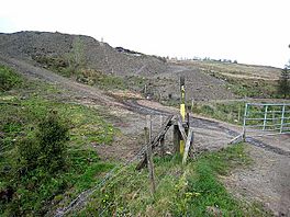
Mining spoil heaps by trail at Arigna
|
|
| Length | 118 km (73 mi) |
| Location | Counties Leitrim, Roscommon & Sligo, Ireland |
| Designation | National Waymarked Trail |
| Trailheads | Arigna |
| Use | Hiking |
| Elevation gain/loss | 2,340 m (7,677 ft) |
| Difficulty | Stenuous |
| Season | Any |
The Miners' Way and Historical Trail is an exciting long-distance walking route in Ireland. It's a big circle, about 118 kilometers (73 miles) long, that starts and finishes in a place called Arigna, in County Roscommon. Most people take about five days to walk the whole trail.
This trail is officially known as a National Waymarked Trail. This means it's a special route recognized by the National Trails Office of the Irish Sports Council. Different local groups, like Roscommon Integrated Development Company and the councils of Roscommon, Leitrim, and Sligo, help manage it.
The trail was created to help bring visitors to the area after the Arigna coal mines closed in 1990. A local priest, Father Sean Tynan, first thought of the idea. Money from the European Regional Development Fund helped build it. The trail officially opened in July 2000.
Contents
Discover the Miners' Way and Historical Trail
The Miners' Way and Historical Trail isn't just one path; it's made up of three main loops that explore parts of Counties Roscommon, Leitrim, and Sligo. These loops let you discover different landscapes and learn about the history of the area.
Exploring the Three Trail Loops
The trail offers different adventures through its three connected loops. Each loop has its own story and sights to see.
The Miners' Way Loop
This part of the trail is about 62 kilometers (39 miles) long. It follows the old paths that miners used to take when they went to work in the Arigna coal mines. Imagine walking in their footsteps! This loop takes you in a circle through towns like Keadue, Ballyfarnon, and around Corrie Mountain. It gives you a real feel for the mining history of the region.
The Historical Trail Loop
The Historical Trail is 56 kilometers (35 miles) long and takes you on a journey around two beautiful lakes: Lough Key and Lough Arrow. As you walk, you'll pass through interesting places like Keadue, Lough Key Forest Park (a great place to explore!), and the town of Boyle. You'll also see ancient sites like Carrowkeel and pass through villages like Castlebaldwin, Highwood, and Ballyfarnon. This loop is perfect for those who love history and stunning lake views.
The Lough Allen Loop
The third part of the trail circles around Lough Allen. This loop guides you through towns such as Drumkeeran, Dowra, and Drumshanbo. It offers different views and experiences, showcasing more of the natural beauty of the area around the lake.
Connecting to the Past: Beara-Breifne Way
Did you know that some parts of the Miners' Way and Historical Trail are also part of an even bigger project? They are part of the Beara-Breifne Way. This is a huge walking and cycling route that is still being developed. It's planned to stretch all the way from the Beara Peninsula in County Cork to Breifne in County Leitrim.
This longer route follows the path of a famous historical march. It traces the journey of Donal Cam O'Sullivan Beare, an Irish chieftain, after a big battle called the Battle of Kinsale in 1602. So, when you walk parts of the Miners' Way, you're also walking a piece of Irish history!
 | Delilah Pierce |
 | Gordon Parks |
 | Augusta Savage |
 | Charles Ethan Porter |

