
Minnesota Point Light facts for kids
 |
|
| The Minnesota Point Light sometime before 1893 | |

Minnesota Point Light
Location in Minnesota
|
|
| Location | Minnesota Point, Duluth, Minnesota |
|---|---|
| Coordinates | 46°42′36.1″N 92°1′33.1″W / 46.710028°N 92.025861°W |
| Year first lit | 1858 |
| Deactivated | 1913 |
| Foundation | Stone |
| Construction | Brick |
| Tower shape | Conical tower |
| Markings / pattern | White |
| Height | 50 ft (15 m) |
| Original lens | Fifth order Fresnel lens |
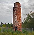
The Minnesota Point Light was a very old lighthouse in Duluth, Minnesota. It stood on Minnesota Point, right by Lake Superior. Built in 1858, it was the first lighthouse ever in Minnesota! Today, it is a ruined tower, but it is still an important historical site. It was added to the National Register of Historic Places in 1974. This lighthouse was special because it was the first powerful lighthouse on Lake Superior. It also marked the starting point for all the first maps of the lake.
Contents
History of the Lighthouse
The first maps of Lake Superior were made in 1823. A British Navy officer named Henry W. Bayfield chose a spot on Minnesota Point as the "zero point" for his mapping. This point is a long, narrow strip of sand that separates Superior Bay from Lake Superior. The original way for ships to enter the bay was east of this point.
The Saint Louis River flows into Superior Bay. Then it goes into Lake Superior through ship canals. These canals are at each end of Minnesota Point. Both Superior, Wisconsin, and Duluth, Minnesota, grew up near this great natural harbor. People quickly saw the need for a lighthouse to guide ships.
Building the First Lighthouse
The United States Congress approved money for the lighthouse in 1855. But cold winters caused delays. So, the light was not turned on until the spring of 1858. The lighthouse was built exactly where Bayfield had marked his zero point.
The tower was round, 40 feet (12 meters) tall, and 12 feet (3.7 meters) wide. It was made of red bricks brought from Cleveland. The bricks were covered with white plaster. On top of the tower was a wooden top with windows facing the lake for the light. A small, two-story house was built next to the tower for the lighthouse keeper. It was made of the same bricks and had a slate roof. Inside the tower, a special Fresnel lens was installed. It showed a steady red light to guide ships.
Changes and Deactivation
The lighthouse keeper's house had some problems, like leaks. But the lighthouse itself did not stay active for very long. In 1868, work began on new piers to protect the Superior Entry. Then, in 1871, a new channel was dug at the other end of the sand bar. This new channel allowed ships to go directly into Duluth harbor.
All these changes meant new lights were needed to help ships navigate. In 1878, a new light was placed on the north pier of the Superior Entry. Because of this, the Minnesota Point Light was turned off. However, this was only for a short time. It was turned back on in 1880.
In 1885, another new pierhead light was built. This time, the Minnesota Point Light was turned off for good. The keeper's house was still used by the keepers of the new north pierhead light. But in 1893, that light was moved to the south pier. This meant a new keeper's house was needed on the other side of the inlet. The old house at Minnesota Point was left empty and eventually disappeared completely.
Today, only the tower remains. Its top part and light are gone. The plaster has worn away from the bricks. A building for buoys was built nearby in 1903, but it is also no longer used. The remains of the tower were officially recognized as a historic place in 1974.
Images for kids
-
Minnesota Point Lighthouse in its present ruined state

