Mirani, Queensland facts for kids
Quick facts for kids MiraniQueensland |
|||||||||||||||
|---|---|---|---|---|---|---|---|---|---|---|---|---|---|---|---|

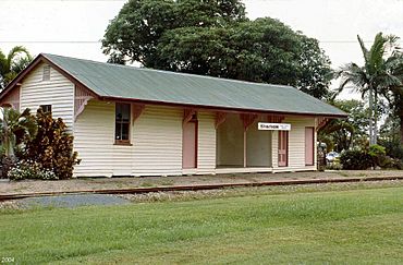
Mirani railway station, 2004
|
|||||||||||||||
| Population | 1,806 (2021 census) | ||||||||||||||
| • Density | 34.80/km2 (90.1/sq mi) | ||||||||||||||
| Postcode(s) | 4754 | ||||||||||||||
| Elevation | 120 m (394 ft) | ||||||||||||||
| Area | 51.9 km2 (20.0 sq mi) | ||||||||||||||
| Time zone | AEST (UTC+10:00) | ||||||||||||||
| Location |
|
||||||||||||||
| LGA(s) | Mackay Region | ||||||||||||||
| State electorate(s) | Mirani | ||||||||||||||
| Federal Division(s) | Capricornia | ||||||||||||||
|
|||||||||||||||
Mirani is a small town and area in the Mackay Region of Queensland, Australia. It's a rural place, meaning it's mostly countryside. In 2021, about 1,806 people lived in Mirani.
Contents
Exploring Mirani's Landscape
The land in Mirani is mostly flat. It's used a lot for growing sugar cane. To the south, you'll find Lake Kinchant. This lake was created by the Kinchant Dam. The Pioneer River flows through Mirani from west to north. It also forms part of the northern border.
The main road, the Mackay–Eungella Road, goes through Mirani. It runs from the east to the north-west. You'll also see many private tramways here. These are special tracks used to carry sugar cane to the Mackay Sugar mills. The town of Mirani is located in the middle of this area. It sits on the eastern side of the Pioneer River.
A Look Back at Mirani's Past
The Yuwibara language is an Australian Aboriginal language. It was spoken in the area where Mirani is today. This language is similar to the Biri languages. The Yuwibara language region covers the land within the Mackay Region.
How Mirani Got Its Name
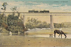
The Pioneer Valley railway line was built in 1885. It connected Mackay to Mirani. Back then, Mirani was called Hamilton. But the name was changed to Mirani. This was to avoid confusion with another town called Hamilton in Brisbane.
Several railway stations served the Mirani area:
- Yeolands railway station (21°09′20″S 148°49′47″E / 21.1555°S 148.8298°E)
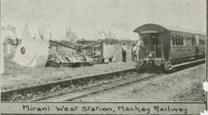
- Mirani West railway station (21°09′28″S 148°51′07″E / 21.1577°S 148.8519°E)
- Mirani railway station (21°09′33″S 148°51′51″E / 21.1591°S 148.8643°E)
- Nanyima railway station (21°09′39″S 148°52′41″E / 21.1607°S 148.8781°E)
- Otterburn railway station (21°09′29″S 148°53′55″E / 21.1580°S 148.8987°E)
Between 1886 and 1896, land became available for farming. This land was part of the Hamilton and Hopetown cattle stations. In 1885, the local postal service changed its name from Hamilton to Hopeton. Then, in April 1890, the Mirani Post Office officially opened.
Schools and Churches in Mirani
Mirani Provisional School first opened its doors on 18 January 1892. It became Mirani State School in 1897. In 1961, the school started offering classes for older students. This continued until a separate high school opened in 1967. The original school was on Augusta Street. On 22 June 1968, the school moved to its current location on Maud Street.
In 1899, a new Catholic church began to be built in Mirani. A new convent opened in 1924, and a new church building opened in 1927.
An Anglican church was also started in 1908. It was named the Church of the Good Shepherd. A new building for this church opened in 1951.
A Presbyterian church also opened in Mirani on 12 July 1908. It was reopened after some changes in 1918.
Local Government and Natural Events
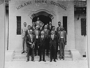
On 4 September 1913, the Shire of Mirani was created. It was separated from the Shire of Pioneer. Mirani became the main town for this new local government area.
The 1918 Mackay cyclone hit the city of Mackay and surrounding areas. This happened on 20–21 January 1918. It was one of the strongest cyclones to hit a populated area in Australia.
Mirani State High School opened on 23 January 1967.
In 2008, the Shire of Mirani joined with the City of Mackay and the Shire of Sarina. Together, they formed the larger Mackay Region.
Mirani's Population
In 2016, about 1,541 people lived in Mirani. By 2021, the population had grown to 1,806 people.
Places of Historical Importance
Mirani has some special places that are protected for their history:
- Victoria Street (21°09′36″S 148°51′51″E / 21.1601°S 148.8641°E): The Lt Thomas Armstrong Memorial
- Victoria Street: The Mirani railway station
Schools in Mirani
Mirani has two main schools:
Mirani State School
Mirani State School is a primary school for students from Prep to Year 6. It's located at 12 Maud Street (21°09′41″S 148°51′43″E / 21.1614°S 148.8619°E). In 2018, the school had 343 students and 20 teachers.
Mirani State High School
Mirani State High School is a secondary school for students from Year 7 to Year 12. You can find it on Augusta Street (21°09′27″S 148°51′44″E / 21.1576°S 148.8623°E). In 2018, there were 842 students and 70 teachers at the high school. It also has a program for special education.
Community Services
The Mackay Regional Council runs a library in Mirani. It's located at 16 Victoria Street.
 | Janet Taylor Pickett |
 | Synthia Saint James |
 | Howardena Pindell |
 | Faith Ringgold |


