
Mississippi River Basin Model facts for kids

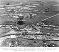
The Mississippi River Basin Model was a giant, outdoor model of the entire Mississippi River system. It was located near Clinton, Mississippi, and covered a huge area of 200 acres (about 150 football fields!). This model was built to help engineers understand and control floods across the vast river basin.
Construction started in 1943, and the model was fully finished in 1966. It was used for important tests from 1949 until 1973. Today, the model is no longer used, but you can visit it in Buddy Butts Park in Jackson.
Contents
Why Was the Model Built?
Dealing with Big Floods
For many years, engineers had built things like levees (high walls along rivers) to control floods. This work became even more important after the massive Great Mississippi Flood of 1927. The Army Corps of Engineers built many locks, channels, and made levees taller.
However, these projects usually focused on just one small part of the river. Engineers realized they needed a way to see how changes in one area affected the entire river system.
The Idea for a Giant Model
Engineers had already made smaller models of river sections at the Waterways Experiment Station in Vicksburg. But in 1937, it became clear that these smaller models weren't enough to solve the big flood problems.
In 1941, a man named Eugene Reybold suggested building a huge model. This model would let engineers test different flood control ideas for the whole river basin. It would cover about 200 acres and include all the rivers and streams, stretching almost 8 miles in total length!
How Was the Model Designed?
Scaling Down the River
The model was built using a special scale. It was 1:100 vertically (meaning 1 foot on the model equaled 100 feet in real life) and 1:2000 horizontally (1 foot on the model equaled 2000 feet in real life).
This meant that the Appalachian Mountains in the model were about 20 feet tall, and the Rocky Mountains were about 50 feet tall. Using a larger vertical scale helped the water flow more realistically, like it would in a real river.
Building the Landscape
The model was made from many concrete panels, each about 10 feet by 10 feet. These panels were shaped to match the real land, including riverbeds, cliffs, lakes, and flood plains. They even included tiny bridges and levees!
To make the water flow correctly, engineers added small metal plugs or bumps in the riverbed. These acted like different types of ground, making the water behave as it would in nature. Folded metal mesh was used to copy the effect of thick forests.
One amazing fact: every gallon of water in the model represented 1.5 million gallons in the real river. This allowed them to simulate a whole day of river flow in just 5 minutes!
Building the Giant Model
Using Prisoner Labor
Building such a massive model needed a lot of workers. Since it was wartime, there weren't many available workers. So, the project decided to use German and Italian prisoners of war.
Construction started in January 1943. First, they built homes for the engineers and a camp for 3,000 prisoners at nearby Camp Clinton. The first prisoners arrived in August 1943, and by December, there were almost 1,800.
Enlisted prisoners were paid 90 cents for 8 hours of work. Officers and non-commissioned officers didn't have to work, but many chose to volunteer. By May 1946, all the prisoners had returned home.
Completing the Project
Parts of the model started being used in 1949, even though it wasn't fully finished. The entire model wasn't completed until 1966. This long construction time was due to how complex the project was and because funding wasn't always steady.
How the Model Was Used
Predicting Floods
By 1952, the section of the model representing the Missouri River was fully working. It was used to predict problems during the April floods that year. This helped prevent an estimated $65 million in damage!
By 1959, the model was complete up to Memphis. A big testing program began, allowing engineers to coordinate the entire model.
Open to Visitors
In 1964, the site opened to visitors. People could take self-guided tours. There was an assembly center, a 40-foot observation tower, and elevated platforms. About 5,000 visitors came each year to see this incredible model.
Final Tests and Standby
Once completed in 1966, the model was used for basin-wide tests. Engineers studied how well reservoirs worked and how to get the best flood protection. For the next three years, they recreated famous floods from 1937, 1943, 1945, and 1952. They also tested what would happen with hypothetical floods at different times of the year.
Tests on specific problems continued until 1971. However, the model was very expensive to run, and computer modeling was becoming more popular. So, the facility was put on standby.
The Last Big Test
The model's last use was in 1973. There was a dangerous situation at the Old River Control Structure. The model was used to show that the Morganza Spillway could be opened safely. This helped avoid sending polluted water through New Orleans and Baton Rouge. It also helped identify which levees needed to be made taller.
What Is Its Status Today?
In 1993, the City of Jackson took over the site. It was named a Mississippi Landmark, and a city park was created around it. However, keeping the model as a tourist attraction was too expensive, so it was left to become overgrown.
In 2000, the model was put on the Mississippi Heritage Trust's "10 Most Endangered List." It gained attention online in 2007 and was visited by many urban explorers and photographers. In 2010, reports said the concrete panels were still mostly intact, and the observation platforms were still there.
In 2011, students from Louisiana State University won an award for their idea to bring the park back to life. They hoped to make the model a tourist attraction again.
In 2013, a reporter visited the site and confirmed it was overgrown but still open to the public within Buddy Butts Park. Later, a news team used a drone to survey the site. They reported it was overgrown, had graffiti, and some parts of the grid were collapsing.
You can access the model through the park entrance on McRaven Road. It's located next to the soccer fields.
A group of local volunteers called "Friends of the Mississippi River Basin Model" has started clearing the model. They hope to open it to the public again. The Libertarian Party of Hinds County also helps with this project.
Images for kids
-
Part of the model

