
Mitchell Heights, West Virginia facts for kids
Quick facts for kids
Mitchell Heights, West Virginia
|
|
|---|---|

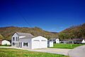
Town Hall in Mitchell Heights
|
|

Location of Mitchell Heights in Logan County, West Virginia.
|
|
| Country | United States |
| State | West Virginia |
| County | Logan |
| Area | |
| • Total | 0.34 sq mi (0.87 km2) |
| • Land | 0.34 sq mi (0.87 km2) |
| • Water | 0.00 sq mi (0.00 km2) |
| Elevation | 669 ft (204 m) |
| Population
(2020)
|
|
| • Total | 315 |
| • Estimate
(2021)
|
310 |
| • Density | 812.50/sq mi (313.73/km2) |
| Time zone | UTC-5 (Eastern (EST)) |
| • Summer (DST) | UTC-4 (EDT) |
| Area code(s) | 304 |
| FIPS code | 54-54892 |
| GNIS feature ID | 1555140 |
Mitchell Heights is a small town located in Logan County, West Virginia, United States. It's a quiet place with a population of 315 people, according to the 2020 census. The town got its name from an old farm that used to be in this area.
Contents
Exploring Mitchell Heights: Location and Surroundings
Mitchell Heights is found at 37°54′25″N 81°58′59″W / 37.90694°N 81.98306°W. It sits right along the west side of the Guyandotte River, which flows through the northern part of Logan County.
To the west of Mitchell Heights, you'll find Chief Logan State Park. This park is a great place for outdoor activities. Nearby communities include Henlawson to the south and Pecks Mill to the north.
West Virginia Route 10 is a main road that goes through Mitchell Heights. This road connects the town to Chapmanville in the north and Logan in the south. The town covers a total area of about 0.87 square kilometers (0.34 square miles), and all of it is land.
People and Population in Mitchell Heights
Mitchell Heights has seen its population change over the years. Here's a quick look at how many people have lived there during different census counts:
| Historical population | |||
|---|---|---|---|
| Census | Pop. | %± | |
| 1950 | 185 | — | |
| 1960 | 290 | 56.8% | |
| 1970 | 524 | 80.7% | |
| 1980 | 342 | −34.7% | |
| 1990 | 265 | −22.5% | |
| 2000 | 301 | 13.6% | |
| 2010 | 323 | 7.3% | |
| 2020 | 315 | −2.5% | |
| 2021 (est.) | 310 | −4.0% | |
| U.S. Decennial Census | |||
What the 2010 Census Showed
During the 2010 census, there were 323 people living in Mitchell Heights. These people lived in 143 households, and 101 of those were families.
The town's population density was about 366 people per square kilometer (950 people per square mile). There were 154 homes, with an average of 175 homes per square kilometer (452.9 per square mile).
Most of the people in Mitchell Heights were White (97.8%). A small number were African American (0.3%), Asian (1.5%), or from two or more races (0.3%). About 0.3% of the population was Hispanic or Latino.
Households and Families
Out of the 143 households:
- 18.9% had children under 18 living with them.
- 57.3% were married couples living together.
- 11.2% had a female head of household with no husband present.
- 2.1% had a male head of household with no wife present.
- 29.4% were not families.
About 25.2% of households had only one person living there. Of these, 19.6% were single people aged 65 or older. The average household had 2.26 people, and the average family had 2.70 people.
Age Groups in Town
The average age of people in Mitchell Heights was 50.2 years old.
- 14.9% of residents were under 18.
- 5% were between 18 and 24.
- 24.4% were between 25 and 44.
- 27.2% were between 45 and 64.
- 28.5% were 65 or older.
When it came to gender, 44.6% of the population was male, and 55.4% was female.
Images for kids
-
Town Hall in Mitchell Heights
See also
 In Spanish: Mitchell Heights (Virginia Occidental) para niños
