Mitchellville, Maryland facts for kids
Quick facts for kids
Mitchellville, Maryland
|
|
|---|---|

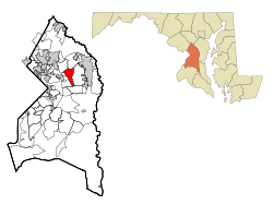
Location of Mitchellville, Maryland
|
|
| Country | |
| State | |
| County | |
| Area | |
| • Total | 4.96 sq mi (12.84 km2) |
| • Land | 4.94 sq mi (12.79 km2) |
| • Water | 0.02 sq mi (0.05 km2) |
| Elevation | 105 ft (32 m) |
| Population
(2020)
|
|
| • Total | 11,136 |
| • Density | 2,255.62/sq mi (870.88/km2) |
| Time zone | UTC−5 (Eastern (EST)) |
| • Summer (DST) | UTC−4 (EDT) |
| ZIP codes |
20716, 20717, 20721, 20720
|
| Area code(s) | 301, 240 |
| FIPS code | 24-52975 |
| GNIS feature ID | 0597758 |
Mitchellville is a community in Prince George's County, Maryland, in the United States. It is known as a census-designated place (CDP). A CDP is a special area that the United States Census Bureau defines for gathering population data. It is not an officially incorporated town or city.
In 2020, about 11,136 people lived in Mitchellville. Most of the people living here are African-American.
Contents
History of Mitchellville
Mitchellville got its name from a person named John Mitchell (1788–1862). He owned a large piece of land called Essington Hall. This land covered much of the area that is now Mitchellville.
John Mitchell and his wife, Mary Lanham, are buried in the Mitchell Family Cemetery. This cemetery is located where Mitchellville and Mount Oak Road meet today. This spot is now part of South Bowie.
Early Maps and Post Office
Old maps from 1878 show "Mitchellville P.O." (which means Post Office) near the same intersection. This tells us that Mitchellville was a recognized place a long time ago. It was also a stop for trains, and the train station often served as the post office too.
Changing Boundaries
It's interesting to know that the Mitchellville we see on maps today is not exactly the same as the original area. The United States Census Bureau updates the boundaries of CDPs. Since 2010, the Mitchellville CDP has shifted a bit. It is now located to the west of the Woodmore CDP. The original Essington Hall is no longer inside the current Mitchellville CDP boundaries.
You can also learn more about the history of this area by looking up Woodmore.
Geography of Mitchellville
Mitchellville is located in Maryland. The United States Census Bureau says that the area of the Mitchellville CDP is about 5.0 square miles (12.8 square kilometers). All of this area is land.
Population Information
Mitchellville's population has changed over the years. Here's how many people have lived there during different census counts:
| Historical population | |||
|---|---|---|---|
| Census | Pop. | %± | |
| 1990 | 12,593 | — | |
| 2000 | 9,611 | −23.7% | |
| 2010 | 10,967 | 14.1% | |
| 2020 | 11,136 | 1.5% | |
| U.S. Decennial Census 2010 2020 |
|||
Who Lives in Mitchellville?
The community of Mitchellville is very diverse. Most residents are African-American. The 2020 census showed that about 82.78% of the people living in Mitchellville were Black or African American. Other groups, including White, Asian, Native American, and people of mixed races, also live in Mitchellville. About 5.66% of the population identified as Hispanic or Latino.
Schools in Mitchellville
Students in Mitchellville attend schools that are part of the Prince George's County Public Schools system.
Elementary Schools
Several elementary schools serve different parts of Mitchellville. These include Kingsford, Ardmore, Woodmore, and Lake Arbor elementary schools.
Middle Schools
Most students in Mitchellville go to Ernest Everett Just Middle School. A smaller part of the area is zoned for Thomas Johnson Middle School.
High Schools
For high school, most Mitchellville students attend Charles Herbert Flowers High School. Some students are zoned to go to DuVal High School.
Local Services
The Prince George's County Police Department helps keep Mitchellville safe. The local police station, District 2, is located in Brock Hall CDP.
See also
 In Spanish: Mitchellville (Maryland) para niños
 | Madam C. J. Walker |
 | Janet Emerson Bashen |
 | Annie Turnbo Malone |
 | Maggie L. Walker |

