
Mixco Viejo facts for kids


Mixco Viejo is an ancient city ruin in Guatemala. It is located about 50 kilometers (31 miles) north of Guatemala City. This site was once a city of the Maya civilization during the Postclassic period.
For a long time, people thought this archaeological site was the capital of the Poqomam Maya people. This Poqomam capital was also called Mixco Viejo in old records. However, experts now know that the ruins you can visit today are actually Jilotepeque Viejo. This was the capital city of the Kaqchikel Chajoma kingdom. To avoid confusion, the ruins of the Chajoma capital are now called Mixco Viejo (Jilotepeque Viejo). The old Poqomam capital is called Mixco Viejo (Chinautla Viejo).
This mix-up made studying the site tricky. Archaeologists studied Jilotepeque Viejo, thinking it was the Poqomam capital. So, the facts they found about the ruins were sometimes linked to the wrong history. A researcher named Robert M. Carmack first noticed this problem. He realized the site was in a Kaqchikel-speaking area, not a Poqomam one. Also, the Poqomam were known for special pottery, but no such pottery was found at these ruins.
The real Poqomam capital, Chinautla Viejo, was attacked by the Spanish in 1525. The Spanish tried twice to capture the strong city but failed. Poqomam fighters came to help, but the Spanish cavalry defeated them in a big battle. The Spanish captured some Poqomam soldiers. These prisoners told them about a secret cave entrance into the city. With this new information, the Spanish launched a third attack. They finally broke through the city's defenses after a month-long siege. The Spanish leader, Pedro de Alvarado, ordered the city to be burned. The people who survived were moved to a new settlement.
The Chajoma people built Jilotepeque Viejo to be a safer capital. Their old capital was too close to their enemies, the Kaqchikel kingdom of Iximche. Even so, Iximche later took control of Jilotepeque Viejo. The city's buildings show a mix of Chajoma and Kaqchikel styles. It was built on a ridge with deep ravines around it, making it easy to defend. When the Spanish arrived, the Chajoma might have first joined them. But they likely joined the Kaqchikel uprising against the Spanish in 1524. After the Spanish conquest, the site was left empty and never lived in again.
Contents
Mixco Viejo in History: Chinautla Viejo
The true historical Mixco Viejo is now known as Chinautla Viejo. It is located near the modern town of Mixco. This city was the capital of the Poqomam Maya kingdom. It was built on a defensive mountaintop around 1100 AD. In the early 1500s, about 10,000 people may have lived there.
In 1525, Pedro de Alvarado sent his soldiers to conquer Mixco Viejo (Chinautla Viejo). The Poqomam people stayed inside their strong city walls. The Spanish tried to attack from the west through a narrow path. But the Poqomam pushed them back, and the Spanish lost many soldiers. Alvarado himself led a second attack with 200 allies from Tlaxcala. He was also forced to retreat.
Then, more Poqomam fighters arrived, possibly from Chinautla. The two armies fought in an open field outside the city. The battle was long and messy. But the Spanish cavalry finally won, making the Poqomam helpers retreat. Three days later, the Poqomam leaders gave up to the Spanish. They told the Spanish about a secret cave entrance to the city. This cave allowed people to go in and out without being seen.
With this secret, Alvarado sent 40 men to guard the cave exit. He then launched another attack from the west, along a ravine. His soldiers went in single file, with crossbowmen and musketeers. Each soldier had a companion holding a shield to block arrows and stones. This plan helped the Spanish break through and storm the city's entrance. The Poqomam warriors ran back in a confused rush. The Spanish and their allies chased them through the city. Those who escaped down a nearby valley were caught by Spanish cavalry waiting at the cave's exit. The survivors were taken back to the city.
The siege had lasted over a month. Because the city was so strong, Alvarado ordered it to be burned. He moved the people who survived to a new colonial village called Mixco.
Archaeological Site: Jilotepeque Viejo

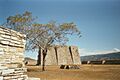
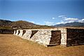
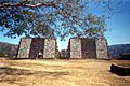
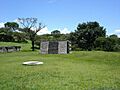
View of Mixco Viejo, including Groups B at left, B-X at bottom right, Group A in the distance and Group D extending at centre right
|
|
| Location | San Juan Sacatepéquez |
|---|---|
| Region | Chimaltenango Department, |
| History | |
| Founded | Postclassic Period |
| Abandoned | c.1521 AD |
| Cultures | Chajoma Maya |
| Site notes | |
| Excavation dates | 1954–1967 |
| Archaeologists | Henri Lehmann IDAEH, CNRS |
| Architecture | |
| Architectural styles | Postclassic Maya |
| Restored by Henri Lehmann and Francisco Ferrus Roig (1954–1967) Responsible body: IDAEH | |
The site known as Mixco Viejo was once thought to be the Poqomam capital. But new studies show it was the capital of the Chajoma Maya. They spoke a dialect of the Kaqchikel language. Experts believe the confusion came from old colonial records. The Chajoma people called their city by different names. These included Chuapec Kekacajol Nima Abaj, which means "Great stone in front of the Cave of the Children of Night."
Jilotepeque Viejo likely had about 1,500 people living there. The city was close to a source of obsidian. This meant the people had easy access to this important volcanic glass.
Today, the site is open to visitors and has a small museum. The Guatemalan government declared it a protected archaeological zone in 1970.
Location of the Ruins
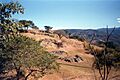
The ruins are in the northeastern part of the Chimaltenango Department. They stretch for over 1 kilometer (0.6 miles) along a high ridge. This ridge is about 880 meters (2,890 feet) high. The site is about 4 kilometers (2.5 miles) from where the Pixcaya River meets the Motagua River. The Motagua River flows into the Caribbean Sea. Deep ravines surround the ruins, dropping sharply into a river branch. The site is about 53 kilometers (33 miles) from Guatemala City by road.
History of Jilotepeque Viejo
Rulers of the Chajoma Kingdom
Here are some of the known rulers of Jilotepeque Viejo:
| Name | Ruled (approx.) | Other names |
|---|---|---|
| Lajuj No'j | c.1450–c.1480 | Ichalkan Chi Kumkwat, Ychal Amollac Chicumcuat |
| Achi Q'alel | early 16th century | – |
Life in the Postclassic Period
Around 1450, the Chajoma people moved their capital to Mixco Viejo (Jilotepeque Viejo). Their king, Lajuj No'j, led them. They wanted a capital that was harder for their enemies to reach. Despite this, the Iximche Kaqchikel kingdom defeated the Chajoma. Jilotepeque Viejo then became part of the Kaqchikel kingdom.
Some parts of the city, like Groups C and E, show Kaqchikel building styles. Other areas, like Groups A and B, have a purer Chajoma style. Both of the city's ballcourts seem to have been changed to fit the Kaqchikel style. They were covered with thick plaster.
Around the 13th century, Group A was greatly changed. A new wall was built, and the area between the old and new walls was filled in. This made a much larger flat area for buildings. Because Jilotepeque Viejo had two ballcourts, it might have been a regional center for the Mesoamerican ballgame. This was during the Postclassic period. No other ballcourts from this period have been found nearby.
Just before the Spanish arrived, the Chajoma, led by their lord Achi Q'alel, fought against the Kaqchikels of Iximche. It's possible that the Chajoma first joined the Spanish, along with Iximche. But they might have also joined the Kaqchikel uprising against the Spanish in 1524. We know that when the lords of Iximche broke their alliance with the Spanish, they hid in Jilotepeque. The site was abandoned after the Spanish conquest. Its people were moved to San Martín Jilotepeque. The area was never lived in again.
Modern Discoveries
A German geographer named Karl Sapper visited the ruins in 1896. He published a short description and a map of the site two years later. He was the one who named the different archaeological groups and their buildings. An American archaeologist, A. Ledyard Smith, visited in 1949. He wrote about the site in his book.
Archaeological digs took place from 1954 to 1967. Henri Lehmann led these excavations. He believed he was digging up the Poqomam capital, as described in old records. The site was restored during these digs. However, it was badly damaged in the 1976 Guatemala earthquake. Some of the restoration work was destroyed. But some of the damage has now been fixed.
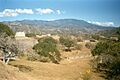
What the Site Looks Like
_map.png)
The ruins have 15 groups of buildings. There are over 120 main structures. These include temples, palaces, and courts for playing the Mesoamerican ballgame. When the site was dug up, archaeologists found many obsidian blades and arrowheads on the surface. The city's main entrance was on the west side. Today, a modern road follows a similar path to the ruins from the west.
Mixco Viejo (Jilotepeque Viejo) was only lived in for a short time. This means its buildings have a very similar style. Almost all the things found there, including artifacts and older versions of buildings, date to the last few hundred years before the Spanish arrived. The buildings were made with mica and pumice slabs. Some were covered with plaster.
There are almost no stone sculptures at the city. The only one found is a ballcourt marker. It looks like a serpent's head with its mouth open, and a human head coming out. Some buildings were decorated with painted plaster. But very little of this has survived.
Experts believe about 1,450 to 1,600 people lived in the city. This number comes from counting the remains of homes.
Building Groups
The buildings are divided into groups and subgroups. Archaeologists labeled them Groups A through L. Subgroups outside the main city walls have an X or an apostrophe. For example, Group A-X or Group C'.
Group A

Group A is at the northern end of the ridge. It was made larger during a big remodeling project. This included building the final versions of Platforms A2 and A3. A new wall was built 12 meters (39 feet) further north, east, and southeast. The area between the old and new walls was filled in. This created a much larger flat area for buildings. Charcoal found at the old wall dates to the 13th century. This means Group A was expanded no earlier than that time.
Pyramid A1 is a main building in Group A, along with the ballcourt. The pyramid is 6.9 meters (23 feet) high. Its base measures 15.4 by 7.25 meters (50.5 by 23.8 feet). It was built with cut stone and has four stepped levels. The pyramid faces west towards the plaza. It has two stairways, each with 27 steps. The stairways have smooth side walls. The top of the pyramid has a 60-centimeter (24-inch) high platform. This platform was once the base for a temple. The pyramid was built over an older plaster platform with two levels.
Platform A5 closes the north side of the Group A plaza. It has two levels on a base. The platform faces south towards the plaza and ballcourt. It was accessed by four stairways, each with nine steps. These stairs had steep ramps or side walls. The Platform A5 we see today covers an older building. This older building was a large platform facing north-south. Archaeologists found two burial urns in this older platform.

Platform A6 closes the western end of the Group A plaza. It has two levels. The platform faces east onto the plaza. It was accessed by two stairways with side walls. Platform A6 was built over an older version of the same building. This older version was smaller. During restoration, parts of the old building were left visible. Four burial urns were found near this platform.
Ballcourt A11 is on the west side of the Group A plaza. It separates the plaza from the ravine behind it. It is a sunken ballcourt, facing north-south and fully enclosed. A short sunken stairway leads from the plaza to the top of the south wall. Another stairway goes down to the southern end of the ballcourt. A similar stairway is in the northern end. The playing area is 37.21 meters (122.1 feet) long and 9.46 meters (31.0 feet) wide. The walls were made of small stone slabs and are slightly sloped. Fragments of plaster show it was at least partly covered.
Group B

Group B is in the center of the site. It is about halfway between Group A (to the northeast) and Group C (to the southwest). The main plaza of Group B was at the northern end. It was surrounded by the ballcourt, a double pyramid, and three platforms. Stairways lead down from Group B towards Groups A and D.
Ballcourt B1 is just south of the Group B plaza. Its northern entrance opens directly onto the plaza. It is an enclosed, sunken ballcourt, common in the Maya highlands. The ballcourt faces north-south. It has two entrances with stairways in the center of the north and south walls. The playing area is 44.5 meters (146 feet) long and 9 meters (30 feet) wide. The ballcourt was originally covered in plaster painted in different colors. Very little of this remains.
During the dig, a well-preserved ballgame marker was found on the western bench. Its original spot was marked by a hole in the wall. The second marker, which would have been opposite, was never found. Replicas of the marker are in both walls. The original is in the Museo Nacional de Arqueología y Etnología in Guatemala City.


Pyramid B3 is actually two pyramids on one base. They are the most important buildings in Group B. The northern pyramid is B3a, and the southern is B3b. Each pyramid has five stepped levels and faces west onto the plaza. Each had one stairway with wide side walls. There was a small altar at the base of each stairway. Both stairways had 19 steps, and the pyramids are 6.17 meters (20.2 feet) high. Low platforms on their tops show where temples once stood.
The idea of twin pyramids came from the Valley of Mexico. This shows that foreign ideas influenced the city. A broken stone monument (stela) was found inside Pyramid B3a. It was a plain monument broken in two pieces. It is one of the few such monuments in the Maya highlands. These stelae are typical of the Classic Period (around 250–900 AD). It's possible it was there before the pyramid was built over it. A burial urn was found under the back of Pyramid B3b.

Platform B8 is a long building on the west side of Group B. It has a base supporting walls that slope inward. The building faces east and has four stairways. The retaining wall of Group B drops into a ravine 2 meters (6.6 feet) behind Platform B8. Many burial urns were found around the base of this platform.
Group B-X

Group B-X includes several buildings outside the walls of Group B. They are to the northwest, northeast, and east of Group B.
Structure B-X3 is a step pyramid. Its sides are so steep that it looks almost like a cube. This temple platform likely had a building made of materials that don't last, but no trace remains. The pyramid faces west. It was accessed by a very steep stairway with 15 steps. This stairway faces the large 13-meter (43-foot) high retaining wall of Group B. The stairway has wide side walls that form the front of the temple platform. Structure B-X3 has been restored.
Group C
Group C is southwest of Group B and east of Group E. It is built around two large structures, C1 and C2. It has two small plazas. The East Plaza is larger and is east of the main temple, Pyramid C1. The West Plaza is behind Platform C2.

Pyramid C1 is the most important building in Group C. Archaeologists found three versions of the pyramid, each built over the last. They restored the pyramid so that parts of all three building phases are visible. The first phase was a platform of cut pumice blocks. This was covered by the second phase, a five-level stepped pyramid. It had a double stairway on the west side, each with 16 steps. The top of the pyramid was 6.1 meters (20 feet) high and had a temple. Parts of this temple still stand. The walls were made of packed earth covered with plaster.
The third and final phase was much larger. It had five levels and only one stairway instead of two. The top of the pyramid was almost 2 meters (6.6 feet) higher than the previous version. Both the second and third versions were originally covered in plaster. New plaster was added during restoration to match the original. The 1976 Guatemala earthquake caused a lot of damage to the pyramid.
A burial was found in front of the earliest pyramid wall. It included clay pots, a necklace of small gold bells, and a copper axe. The presence of metal items shows that all three building phases happened fairly quickly. More pottery was found under the later two phases. An artificially shaped skull was buried under the center of the final version.
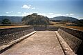
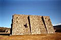
Platform C2 faces Pyramid C1 and borders the Group C Plaza. It is a long, rectangular building, 47.3 by 14 meters (155 by 46 feet). It is the highest structure at Mixco Viejo (Jilotepeque Viejo). The platform has two levels and is 4.4 meters (14 feet) high. The entire platform was once covered in plaster. Traces of plaster on the upper level show that several homes once stood there. Platform C2 was built on an older, shorter platform. It likely controlled access to Pyramid C1. Several burial urns were found at the base of Platform C2.

Structure C8 was a residential compound. It was accessed from an alley behind Pyramid C1. The entrance opened onto a patio in the southern part of the compound. This patio was surrounded by rooms on three sides. It had a plaster floor. Structure C8 was the only plastered residential building in the city. Its high quality suggests it was the home of an important person. Because it was so close to the large temple C1, archaeologist Henri Lehmann thought it might have been the home of the high priest.
Group D

Group D is spread out to the east of Group B.
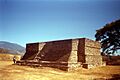
Pyramid D1 is on the east side of the Group D plaza. It had three stepped levels on a low base. It faces west towards the plaza and had one stairway. The pyramid was well-built with finely cut stone slabs. However, it was not well preserved, and the southern part had partly collapsed. Archaeologists were able to restore it accurately.
Structure D4 is a small altar in the center of the Group D plaza.
Platform D5 is a long building facing south. It has only two stairways. Digs found several burial urns under the back wall of this building. This is the only place where urns were buried behind such a platform.
Group E

Group E is west of Group C. It is mostly surrounded by steep ravines. The city's people made the cliffs steeper for defense and built a retaining wall. Archaeologists did not find any stairway through the wall to Group E.
Pyramid E1 is on the east side of the Group E plaza. It was the most important building in Group E. The pyramid had three building phases. The oldest was built from pumice on a natural 2-meter (6.6-foot) high hill. This early phase was filled with rounded pebbles for the second phase. The third and final phase was larger. It had four stepped levels on a base. It faced west with a stairway. A small altar was found at the base of the pyramid. Two stones were on it: one round, one with a hole, possibly a mace or club. Several burial urns were found at the base of the pyramid's south side.
Structure E3 is a square altar in the middle of the Group E plaza. It faces Pyramid E1.
Platform E4 is behind Pyramid E1. It closes the eastern side of the Group E plaza. It faces west onto the plaza and has two stairways. The platform walls are well-made with carefully fitted pumice. The front of the upper platform was paved with stone slabs. A bench ran along the back of the platform. An offering was found in the center of the platform's base. It included two ring-shaped clubs and a stone ball.
Platform E6 is on the west side of the Group E plaza. It is roughly built from uneven stones. The platform faces east towards Pyramid E1 and has four stairways. This platform once supported homes made of corn stalks and clay. The platform itself was once covered with plaster.
Other Groups
Group E' is a cluster of small buildings between the hills of Groups C and E.
Group F is west of Group E. Mound F is its main structure. It slopes gently to the west and was not easy to defend there. However, it was outside the main fortress walls. It seems to have been a lookout platform covering the western path to the city. A wall supported the mound above the path. A round earth platform on the mound might have held a watchtower.
Group G has several small buildings along the ridge north of Group A.
Group H is a small group northeast of Group A. Structure H1 is a platform built on a natural mound.
Group I is also called the Campana Group. It is the northernmost group at Mixco Viejo (Jilotepeque Viejo).
Group J is a group of small buildings southwest of Group A, right next to it.
Caves
Three small caves are found in the sides of the ridge where the city ruins are. Archaeologists found that two of these caves were changed by people long ago.
Cueva de La Lola ("Lola's Cave") is below Group A, near the Pancaco River. The cave is 8.7 meters (29 feet) deep and 6.1 meters (20 feet) wide. It was made wider and taller by people. During the rainy season, water flows out of the cave as a small waterfall. The cave was used for ceremonies. This was because of the spring inside and its green walls. Green stone was sacred to the Maya and linked to water and new life. People still hold ceremonies in the cave today.
Cueva del Murciélago ("Cave of the Bat") is at the southern end of the site. It is 14.3 meters (47 feet) deep. It was made wider for access. It was still used for Maya ceremonies in the late 1900s. Archaeologists found recent signs of activity there.
Burial Offerings
Many burial urns were found at the base of buildings. People were cremated, and their ashes were put into these urns. The urns had three holes, perhaps for the eyes and mouth of the person. They were decorated with colorful serpent designs in black, red, and cream. This pottery style is called Chinautla Polychrome.
The Maya custom of burying ashes in urns was only for important people. Common people were buried in simple tombs outside the city center. In Jilotepeque Viejo, urns were usually buried under the front of platforms or under the sides of pyramids and altars. This was a unique tradition for this city. Burial urns have been found under all the main plazas.
A total of 52 urns were found at Jilotepeque Viejo. Eight were destroyed in the 1976 earthquake, leaving 44 for study. Twelve of these were in a museum in Paris for about 30 years. All artifacts from Mixco Viejo (Jilotepeque Viejo) were returned to Guatemala in 1998. Each urn held the ashes of one adult. All seemed to be older adults. Young adults were not found, meaning young warriors might have been buried differently.
Analysis of bone fragments showed that the whole body was burned. However, a skull was found as an offering in Pyramid C1. Skull fragments showed that important people in the city practiced artificial skull shaping. Animal bones were also found mixed with the ashes in many urns. These included deer bones and bones from birds like parrots and birds of prey.
Only six of the urns had other items buried with them:
| Urn | Structure | Offering |
|---|---|---|
| Urn 6317 | C2 | a small serpentine axe, tweezers, and a worked deer bone |
| Urn 6826 | B8 | two perforated animal bone tubes and a jadeite bead |
| Urn 6835 | B3b | a small green stone and a piece of a prismatic blade |
| Urn 6899 | ? | a copper spatula |
| Urn 7602 | A5 | three pieces of greenstone and four jadeite beads |
| Urn 7607 | D1 | four obsidian blades, tweezers, and a piece of a greenstone bead |
Images for kids
-
View of Group A of Mixco Viejo (Jilotepeque Viejo)
-
View of Mixco Viejo, including Groups B at left, B-X at bottom right, Group A in the distance and Group D extending at centre right
-
Platform C2
-
View across Group E from Group C
-
Platform A5, with Platform A6 behind
-
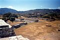
View across the Group B plaza to Ballcourt B1 and Platform B8; double pyramid B3 is at bottom left and Platform B2 at left; Group C is visible beyond Platform B8.
-
Playing alley of Ballcourt B1
-
Pyramid D1
-
Twin pyramids B3
-
The lower part of Group C, with Structures C11 and C14
-
Pyramid A1, one of the principal structures of Group A
-
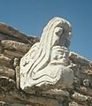
This ballcourt marker is the only example of stone sculpture recovered from Mixco Viejo (Jilotepeque Viejo)
-
Temple B-X3
See also
 In Spanish: Mixco Viejo para niños
