Moel y Gaer, Llanbedr facts for kids
Quick facts for kids Moel-y-Gaer Camp |
|
|---|---|

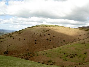
View of Moel y Gaer from the south
|
|
| Type | hillfort |
| Location | Denbighshire, Wales |
| OS grid reference | SJ 1490 6175 |
| Elevation | 320 metres (1,050 ft) |
| Official name: Moel-y-Gaer Camp | |
| Reference no. | DE010 |
| Community | Llanbedr-Dyffryn-Clwyd |
| Principal area | Denbighshire |
| Lua error in Module:Location_map at line 420: attempt to index field 'wikibase' (a nil value). | |
Moel y Gaer is an ancient hillfort located in Wales. Its name means "bald hill of the fortress" in Welsh. This important historical site is found on a hill near the village of Llanbedr in Denbighshire.
Moel y Gaer is a special kind of hillfort from the Iron Age. It was a large, protected settlement built on a hill. Today, it is recognized as a "scheduled monument," which means it's a very important historical place that is protected by law.
This hillfort is one of six similar sites in the Clwydian Range area. These hillforts stretch from north to south and include Moel Hiraddug, Moel y Gaer Bodfari, Penycloddiau, Moel Arthur, Moel y Gaer Llanbedr, and Moel Fenlli.
Contents
What Does Moel y Gaer Look Like?
Moel y Gaer hillfort is surrounded by steep slopes on its north, west, and south sides. This made it naturally difficult for enemies to attack. The easiest way to get in was from the east, where the main entrance was located. There was also another entrance on the west side, but it wasn't used for everyday access.
Most of the fort is protected by two large banks of earth and two ditches. Near the main entrance to the northeast, there are even more banks. These extra defenses helped protect the fort from attacks coming from the higher ground towards Moel Famau.
How Big is the Hillfort?
The hillfort is shaped like a rounded oval. It measures about 200 metres (660 ft) from north to south and about 180 metres (590 ft) from west to east. The main part of the fort covers an area of about 2.63 hectares (6.5 acres). There's also a smaller section, or "annex," to the north, which adds another 0.26 hectares (0.64 acres). This means the total area of the hillfort is about 2.89 hectares (7.1 acres).
Why Was This Location Chosen?
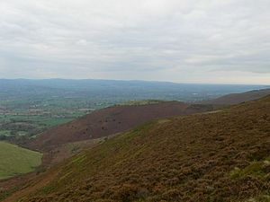
Moel y Gaer sits at a height of about 320 metres (1,050 ft) to 345 metres (1,132 ft). It's actually lower than some of the other hillforts in the chain and isn't right on the main ridge of the Clwydian Range. However, it still offers an amazing view over the Vale of Clwyd. This commanding position would have been perfect for watching out for anyone approaching.
Discovering Moel y Gaer's Past
People have been studying Moel y Gaer for a long time to learn about its history.
Early Investigations
One of the first people to investigate the hillfort was W. Wynne-Ffoulkes in 1849. He dug several small trenches. He believed that the eastern entrance had a paved path and that the inner wall of the fort was made of stone. He also found an area with many burnt stones, which suggests there might have been a big fire. Sadly, many of the old objects found during his digs have since been lost.
Modern Surveys and Finds
More recently, in 2007, a detailed survey was done. This survey found 15 round platforms inside the fort. These platforms were likely where roundhouses (circular homes) once stood. The survey also found more evidence that the inner wall might have been faced with stone at some point. There was also clear evidence of a major fire, with burnt stone fragments and even a block of "vitrified" material. Vitrified material is rock that has been melted and turned into a glass-like substance by intense heat.
In 2008, another survey used special equipment to look underground without digging. This "Archaeology Uncovered" event even had members of the public helping out! They used tools like magnetic susceptibility and fluxgate gradiometers to find hidden features. These surveys found possible paved paths and lines that could be old stone walls.
Digging Deeper with Bangor University
In 2009, a team from Bangor University started digging two trenches at the site. This project was also a training school for students from Bangor and the University of Vienna in Austria. It was a community archaeology project, meaning local people could get involved too!
From their studies, experts think that Moel y Gaer hillfort was used during at least two different periods. The first period was in the Early Iron Age, when the inner wall was built. Then, possibly in the Middle or Late Iron Age, the outer walls were added.
Protecting This Ancient Site
Moel y Gaer is not only a protected "scheduled monument," but it's also part of a special program called the "Heather and Hillforts Project." This project helps to protect and manage several important hillforts in the area. The project includes four of the southernmost hillforts in the Clwydian Range: Penycloddiau, Moel Arthur, Moel y Gaer Llanbedr, and Moel Fenlli. It also helps protect Moel y Gaer Llantysilio and Caer Drewyn.
 | Stephanie Wilson |
 | Charles Bolden |
 | Ronald McNair |
 | Frederick D. Gregory |


