Moel y Gaer, Bodfari facts for kids
Quick facts for kids Moel y Gaer |
|
|---|---|

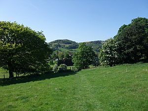
Moel y Gaer on the horizon, from Offa's Dyke Path
|
|
| Type | hillfort |
| Location | Denbighshire, Wales |
| OS grid reference | SJ 0950 7080 |
| Elevation | 200 metres (660 ft) |
| Official name: Moel y Gaer | |
| Reference no. | FL073 |
| Community | Bodfari |
| Principal area | Denbighshire |
| Lua error in Module:Location_map at line 420: attempt to index field 'wikibase' (a nil value). | |
Moel y Gaer is an ancient hillfort located in Wales. Its name comes from the Welsh language and means "bald hill of the fortress." This historic site sits on a hilltop at the northern end of the Clwydian Range.
It overlooks the beautiful valley of the River Wheeler, close to the village of Bodfari. Moel y Gaer is about five miles northeast of Denbigh. It is a special protected site, recognized as a prehistoric defensive hillfort.
Contents
What is Moel y Gaer?
Moel y Gaer is a type of ancient fort built during the British Iron Age. The Iron Age was a time in history when people started using iron to make tools and weapons. This period in Britain lasted from about 800 BC to 100 AD.
People built hillforts like Moel y Gaer on high ground. This gave them a good view of the surrounding area. It also made it easier to defend against enemies.
Location and Importance
Moel y Gaer is part of a chain of six hillforts in the Clwydian Range. These forts stretch from north to south. The other hillforts in this chain include Moel Hiraddug, Penycloddiau, Moel Arthur, Moel y Gaer Llanbedr, and Moel Fenlli.
Moel y Gaer Bodfari is the lowest of these forts, sitting about 200 m (656 ft) above sea level. Even though it's lower, its location was very important. It stands on a hill surrounded by lower land. This spot is where the River Wheeler and the Clwyd meet.
The famous Offa's Dyke Path, a long-distance walking trail, passes right at the foot of the hill. This shows how important the area has been throughout history.
Design of the Fort
The fort at Moel y Gaer is one of the smaller ones in the Clwydian Range chain. It was likely built during the Iron Age. However, experts are still working to find out exactly when people lived there.
The fort has only one entrance, which is on its northern side. The eastern side of the hill is very steep. This natural slope helped to protect the fort from invaders.
Discovering the Past: Excavations
Archaeologists started digging at Moel y Gaer in 2011. These excavations continued for several years. The area inside the fort's walls covers about two hectares, which is like the size of two rugby fields.
During the digs, archaeologists looked for interesting spots. They found what might be a group of pits and other places where the ground seemed to have been dug out. They also found what looks like a roundhouse on a flat piece of land. A roundhouse was a common type of home in the Iron Age.
In 2013, they began to study the middle wall of the fort. It seems that this wall was built in different stages over time. Each new discovery helps us learn more about the people who lived here long ago.
 | Charles R. Drew |
 | Benjamin Banneker |
 | Jane C. Wright |
 | Roger Arliner Young |

