
Foel Fenlli facts for kids
Quick facts for kids Foel Fenlli |
|
|---|---|
 |
|
| Highest point | |
| Elevation | 511 m (1,677 ft) |
| Prominence | 153 m (502 ft) |
| Parent peak | Moel Famau |
| Listing | Marilyn |
| Geography | |
| Location | Denbighshire, Wales |
| Parent range | Clwydian Range |
| OS grid | SJ164600 |
| Topo map | OS Landranger 116 |
Foel Fenlli or Moel Fenlli is a fantastic hill located in Denbighshire, North Wales. It stands at 511 meters (about 1,677 feet) high, making it the second tallest peak in the Clwydian Range. This hill is a popular spot for hikers and history lovers, thanks to its amazing views and ancient secrets hidden at the top.
Contents
Exploring Foel Fenlli
Foel Fenlli is a great place for an adventure! Many people start their climb from the car park at Bwlch Penbarras. This spot is also a starting point if you want to hike up Moel Famau, which is another famous peak nearby. As you walk, you might notice the Offa's Dyke Path, a long-distance trail that goes around the western side of the hill. It's a fun way to see the beautiful Welsh countryside.
The Ancient Hillfort
One of the most exciting things about Foel Fenlli is the ancient hillfort at its summit. Imagine a huge, old fort covering about ten football fields! Experts believe this fort was first built way back in the Iron Age. That's thousands of years ago! Later, people lived there again during a period called the Dark Ages.
King Benlli's Legend
Legend says that a powerful king named Benlli lived in this hillfort around the year 450 AD. The mountain is even named after him! Stories tell that King Benlli had a disagreement with Saint Germanus. The legend says that King Benlli and his castle were destroyed by a powerful force. It's a dramatic story that adds to the mystery of this ancient place.
Inside the Fort
Even today, you can see the remains of strong walls, called ramparts, all around the hillfort. There's an entrance on the western side. If you explore the south-west part of the fort, you'll find about two dozen flat areas. These are believed to be where huts once stood, showing us where people lived long ago. There's even a natural spring close to the center of the fort, which would have been a vital water source for the people living there.
Images for kids
-
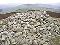
Cairn at the summit

