Mokane, Missouri facts for kids
Quick facts for kids
Mokane, Missouri
|
|
|---|---|
| City of Mokane | |

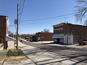
Downtown Mokane in March 2019
|
|

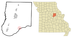
Location of Mokane, Missouri
|
|
| Country | United States |
| State | Missouri |
| County | Callaway |
| Area | |
| • Total | 0.29 sq mi (0.76 km2) |
| • Land | 0.29 sq mi (0.76 km2) |
| • Water | 0.00 sq mi (0.00 km2) |
| Elevation | 532 ft (162 m) |
| Population
(2020)
|
|
| • Total | 188 |
| • Density | 641.64/sq mi (247.66/km2) |
| Time zone | UTC-6 (Central (CST)) |
| • Summer (DST) | UTC-5 (CDT) |
| ZIP code |
65059
|
| Area code(s) | 573 |
| FIPS code | 29-49070 |
| GNIS feature ID | 2395364 |
Mokane is a small city in Callaway County, Missouri, United States. It was first called Smith's Landing, then Saint Aubert. In 2020, about 188 people lived there. Mokane is part of the Jefferson City area.
Contents
A Look Back: Mokane's History
Mokane is one of the oldest towns in Callaway County. It was first settled around 1818 by Thomas Smith. Because of him, the settlement was named Smith's Landing.
How Mokane Got Its Name
Around 1849, a post office was built in the settlement. At that time, its name changed to Saint Aubert. Maps from 1876 still showed the town as Saint Aubert.
The Railroad's Role
A big change happened on July 1, 1893. A railroad company, the Missouri, Kansas and Eastern Railway, took over the train line that went through the town. This line connected to Saint Louis. The town had a train station stop.
Within a few years, the town got a new name. This name came from the railroad company's name: Mo., Kan. & E. By 1897, official maps showed the town as "Mokane". The town also moved a bit north because the old Saint Aubert area was flooded.
Where is Mokane Located?
Mokane is on the north side of the Missouri River valley. It is located along Missouri Route 94. Nearby towns include Tebbetts to the southwest and Steedman to the northeast. Fulton is about twelve miles north.
Rivers and Trails
The Katy Trail runs right through Mokane. This trail is a popular path for hiking and biking. It was made from old railroad lines. Mokane is at mile 125 on the Katy Trail.
The city covers a total area of about 0.76 square kilometers (0.29 square miles). All of this area is land.
How Many People Live in Mokane?
The number of people living in Mokane has changed over the years. In 1900, there were 331 people. The population grew to 726 by 1920. After that, the number of residents slowly decreased.
| Historical population | |||
|---|---|---|---|
| Census | Pop. | %± | |
| 1900 | 331 | — | |
| 1910 | 646 | 95.2% | |
| 1920 | 726 | 12.4% | |
| 1930 | 575 | −20.8% | |
| 1940 | 544 | −5.4% | |
| 1950 | 477 | −12.3% | |
| 1960 | 419 | −12.2% | |
| 1970 | 398 | −5.0% | |
| 1980 | 293 | −26.4% | |
| 1990 | 186 | −36.5% | |
| 2000 | 188 | 1.1% | |
| 2010 | 185 | −1.6% | |
| 2020 | 188 | 1.6% | |
| U.S. Decennial Census | |||
In 2010, there were 185 people living in Mokane. Most residents were White. About 46.6% of households had children under 18. The average age in the city was 26.8 years old.
See Also
 In Spanish: Mokane (Misuri) para niños
 | Leon Lynch |
 | Milton P. Webster |
 | Ferdinand Smith |

