
Molenwaard facts for kids
Quick facts for kids
Molenwaard
|
|||
|---|---|---|---|
|
Former municipality
|
|||

A view of Kinderdijk at sunrise
|
|||
|
|||

Location in South Holland
|
|||
| Country | Netherlands | ||
| Province | South Holland | ||
| Municipality | Molenlanden | ||
| Established | 1 January 2013 | ||
| Merged | 1 January 2019 | ||
| Area | |||
| • Total | 126.47 km2 (48.83 sq mi) | ||
| • Land | 118.29 km2 (45.67 sq mi) | ||
| • Water | 8.18 km2 (3.16 sq mi) | ||
| Elevation | −1 m (−3.3 ft) | ||
| Population
(May 2014)
|
|||
| • Total | 28,986 | ||
| • Density | 245/km2 (630/sq mi) | ||
| Time zone | UTC+1 (CET) | ||
| • Summer (DST) | UTC+2 (CEST) | ||
| Postcode |
2957–2977
|
||
| Area code | 0184 | ||


Molenwaard was a former municipality in the western Netherlands. A municipality is like a local government area, similar to a city or a county. Its name comes from the Dutch words molen (meaning 'mill') and waard (meaning 'flat riverland'). This is fitting because many windmills are found in this area.
Molenwaard was located in the province of South Holland. It was formed on January 1, 2013, when three smaller municipalities – Graafstroom, Liesveld, and Nieuw-Lekkerland – joined together. On January 1, 2019, Molenwaard merged again with another municipality called Giessenlanden. Together, they now form the new municipality of Molenlanden.
Before it merged, Molenwaard had about 29,000 people living there. Its total area was about 126 square kilometers (49 square miles). The biggest towns in Molenwaard were Bleskensgraaf, Groot-Ammers, and Nieuw-Lekkerland.
Geography and Landscape
Molenwaard is famous for its unique landscape of polders. Polders are low-lying areas of land that have been reclaimed from water. This means they are below sea level and protected by dikes. The area has many large pastures, which are fields for animals, crossed by ditches and canals. Some important waterways include the Groote- of Achterwaterschap and the Ammersche Boezem.
The most famous part of Molenwaard is the windmills of Kinderdijk. These historic windmills are located in the northwest of the area. Molenwaard is about 1.5 meters (5 feet) below sea level. It is bordered by the Lek river to the north and the Noord river to the west. The Graafstroom and the Alblas rivers also flow through this beautiful region.
Towns and Villages
Molenwaard was made up of many small towns and villages. Each of these places has its own history and community. Here are some of the settlements that were part of Molenwaard:
- Bleskensgraaf
- Brandwijk
- De Donk
- Gelkenes
- Gijbeland
- Goudriaan
- Graafland
- Groot-Ammers
- Hofwegen
- Kinderdijk
- Kooiwijk
- Langerak
- Liesveld
- Molenaarsgraaf
- Nieuw-Lekkerland
- Nieuwpoort
- Ottoland
- Oud-Alblas
- Streefkerk
- Vuilendam
- Waal
- Wijngaarden
Famous People from Molenwaard
Many interesting people have come from the Molenwaard area. They have made contributions in different fields like history, sports, and politics.
.jpg)

- Johannes Gysius (around 1583 – 1652): A Dutch historian and a minister.
- Fop Smit (1777 – 1866): A skilled Dutch ship designer and builder.
- Aart den Boer (1852 – 1941): A Dutch architect and builder.
- Simon Bon (1904 – 1987): A Dutch rower who competed in the Olympic Games.
- Els Veder-Smit (born 1921 – 2020): A Dutch politician.
- Willem Aantjes (1923 – 2015): A Dutch politician and legal expert.
- Ad Dekkers (1938 – 1974): A Dutch artist known for his relief artworks.
- Gert Schutte (born 1939 – 2022): A Dutch politician and teacher.
- Dirk van der Borg (born 1955): A Dutch politician who served as the Mayor of Molenwaard.
- Corien Wortmann-Kool (born 1959): A Dutch politician and a Member of the European Parliament.
- Maarten Demmink (born 1967): Known as Demiak, he is a Dutch painter, photographer, and sculptor.
- Merijn Korevaar (born 1994) and Jeanne Korevaar (born 1996): Dutch racing cyclists.
Images for kids
-
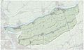
Map of the municipality of Molenwaard, June 2015

