
Monkton, South Ayrshire facts for kids
Quick facts for kids Monkton |
|
|---|---|
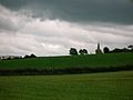
 The Hare Stone and a view of Monkton. |
|

Monkton
|
|
| Area | 2.44 km2 (0.94 sq mi) |
| Population | 1,130 (2020) |
| • Density | 463/km2 (1,200/sq mi) |
| OS grid reference | NS 35752 27835 |
| Council area | |
| Lieutenancy area |
|
| Country | Scotland |
| Sovereign state | United Kingdom |
| Post town | Prestwick |
| Postcode district | KA9 |
| Police | Strathclyde |
| Fire | Strathclyde |
| Ambulance | Scottish |
| EU Parliament | Scotland |
| UK Parliament |
|
| Scottish Parliament |
|
Monkton is a small village in South Ayrshire, Scotland. It is part of the Monkton and Prestwick area. The town of Prestwick is about 1.5 miles (2.4 km) south of Monkton. The village is also very close to Glasgow Prestwick Airport.
Contents
History of Monkton
The village of Monkton was once known by a different name: Prestwick Monachorum.
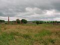
The Old Windmill
On a hill in Monkton, you can see a tall, tower-like building. This building was first used as a windmill in the 1600s. Windmills use wind power to grind grain. Later, in the 1700s, it was changed into a doocot. A doocot is a special building where pigeons or doves are kept.
This old windmill is different from another tall structure you might see. That one is called the Shaw Monument. It was built by a landowner to watch falcon hunting. The Monkton windmill has a rounded roof and special nesting boxes for the birds.
Views of the Area
-
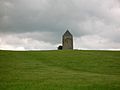
The old Windmill, also known as the Dovecot.
-
The MacRae of Orangefield Memorial, located near the Dutch Barn Caravan Park.
-
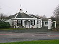
Fairfield Lodge.
-

Monktonhead Lodge. The road to Monktonhead House is now shorter because of a bypass.


Monkton's Climate
Monkton has an oceanic climate. This means it has mild temperatures and rain throughout the year. The closest weather station is at Prestwick Airport, about 1 km (0.6 mi) east of the village. It is 27 meters (89 ft) above sea level.
| Climate data for Prestwick RNAS (27 m asl, averages 1981–2010) | |||||||||||||
|---|---|---|---|---|---|---|---|---|---|---|---|---|---|
| Month | Jan | Feb | Mar | Apr | May | Jun | Jul | Aug | Sep | Oct | Nov | Dec | Year |
| Mean daily maximum °C (°F) | 7.3 (45.1) |
7.5 (45.5) |
9.3 (48.7) |
11.6 (52.9) |
14.8 (58.6) |
17.0 (62.6) |
18.5 (65.3) |
18.4 (65.1) |
16.2 (61.2) |
13.1 (55.6) |
9.9 (49.8) |
7.5 (45.5) |
12.6 (54.7) |
| Mean daily minimum °C (°F) | 1.8 (35.2) |
1.8 (35.2) |
3.0 (37.4) |
4.4 (39.9) |
6.7 (44.1) |
9.7 (49.5) |
11.8 (53.2) |
11.5 (52.7) |
9.8 (49.6) |
7.2 (45.0) |
4.3 (39.7) |
1.9 (35.4) |
6.2 (43.1) |
| Average rainfall mm (inches) | 90.2 (3.55) |
64.8 (2.55) |
77.5 (3.05) |
54.6 (2.15) |
50.2 (1.98) |
59.8 (2.35) |
74.0 (2.91) |
84.1 (3.31) |
83.4 (3.28) |
111.6 (4.39) |
93.7 (3.69) |
94.8 (3.73) |
938.7 (36.94) |
| Average rainy days (≥ 1 mm) | 16.2 | 12.8 | 13.9 | 11.2 | 10.1 | 10.7 | 12.2 | 13.1 | 12.5 | 15.7 | 15.9 | 15.3 | 159.6 |
| Mean monthly sunshine hours | 41.7 | 71.5 | 103.2 | 158.2 | 214.1 | 190.8 | 182.7 | 167.1 | 123.1 | 91.5 | 56.0 | 38.9 | 1,438.8 |
| Source: Met Office | |||||||||||||
Monkton Old Church
Monkton's old church was built in the 1200s and was named after St. Cuthbert. People used this church until 1837. A new church was built nearby in 1834.
The nephew of the famous poet Robert Burns, the Reverend Thomas Burns, helped build the new church. For a while, people even called it "Burns's Folly."
An old poem by Blind Harry tells a story about this church. It says that the Scottish hero William Wallace once prayed there. He fell asleep and had an important dream that gave him the courage to keep fighting for Scotland's freedom from Edward I.
Views of Monkton Church and Cemetery
-
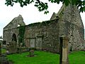
The south side of the church.
-
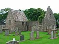
The northern part of the church, built in the 1600s.
-
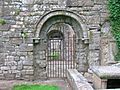
The fancy entrance to Saint Cuthbert church, from the 1600s.
-
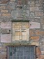
A detailed carved cross on the 17th-century part of the church.
-
The burial place of William Weir of Adamton and Kildonan.
-
The Angus of Ladykirk aisle, a special section of the church.


Monkton Station
Monkton station opened on August 5, 1859. It was part of the Glasgow, Paisley, Kilmarnock and Ayr Railway. Later, this railway became the Glasgow and South Western Railway.
The station closed on October 28, 1940. Today, the area where the station once stood is used for fuel unloading for Prestwick Airport. The closest train station to Monkton now is Prestwick International Airport Railway Station, which opened in 1994.
Fairfield House
Colonel William Fullarton used to own Fairfield House. He sold it around 1803 before moving to Trinidad. In 1851, William Gunning Campbell owned the house. He had many staff, including a housekeeper, gardeners, and housemaids.
The property had a special walled garden, which is now in ruins. It also had a cemetery garden that is still in good condition. An old Scottish measurement called a "fall" is mentioned on a stone there. The last Campbell family member to live at Fairfield was W. G. Campbell.
In the 1860s, a nearby estate called Orangefield was added to Fairfield. This made Fairfield a very large property. Fairfield House was sold in 1950 and then torn down by the new owner. He had plans to build new houses and horse racing stables there.
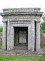
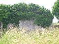
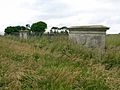
Campbell Family Cemetery Garden
-
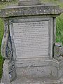
The dedication stone from 1835.
-
The Christian dedication stone for the '2 falls' cemetery garden.
-
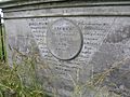
The gravestone and writing for William and Diana Campbell.
-
The mausoleum, a building for burials.
-
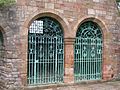
The railings and walls at the front of the cemetery garden.
-
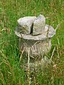
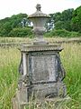
The base of an old sundial.
-
Fairfield Lodge.


Orangefield House
James MacRae
Monkton House was rebuilt by James MacRae (1684–1746). He was a very important person who served as the President of Madras (a city in India) from 1725 to 1730. He returned to Scotland with a huge amount of money.
In 1736, he bought the Monkton estate. He then renamed the house 'Orangefield'. He did this because he greatly admired William of Orange, who was King William III of England. James MacRae passed away at Orangefield in 1746.
The MacRae Monument
The MacRae Monument is also known as the 'Orangefield Family Burial Ground'. It was built around 1750 by John Swan. The monument has a special style called Corinthian, with arches, decorative urns, and a tall, pointed stone called an obelisk. This site was used as a burial place for the Orangefield family.
See also
 In Spanish: Monkton (South Ayrshire) para niños
Images for kids
-
The old walled garden at Fairfield.
-
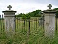
The gates to the cemetery.
-
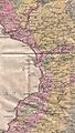
William Aiton's map from 1811, showing Monkton.


