Montague, California facts for kids
Quick facts for kids
Montague, California
|
|
|---|---|
| City of Montague | |

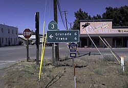
Junction of CA-3 and CR A28
|
|

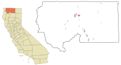
Location in Siskiyou County and the state of California
|
|
| Country | |
| State | |
| County | Siskiyou |
| Incorporated | January 28, 1909 |
| Named for | S. S. Montague |
| Area | |
| • Total | 1.79 sq mi (4.64 km2) |
| • Land | 1.78 sq mi (4.60 km2) |
| • Water | 0.01 sq mi (0.04 km2) 0.85% |
| Elevation | 2,539 ft (774 m) |
| Population
(2020)
|
|
| • Total | 1,226 |
| • Density | 786.28/sq mi (303.62/km2) |
| Time zone | UTC−8 (Pacific Time Zone) |
| • Summer (DST) | UTC−7 (PDT) |
| ZIP code |
96064
|
| Area code | 530 |
| FIPS code | 06-48690 |
| GNIS feature IDs | 277557, 2411140 |
Montague is a small city in Siskiyou County, California, in the United States. It's a great place to learn about how cities are named and how their populations change over time. In 2020, about 1,226 people lived here.
Contents
What's in a Name?
Montague got its name from a very important person in railroad history. The city was named after S.S. Montague. He was the chief engineer for the Central Pacific Railroad. This happened when the railroad line was extended in 1886 and 1887.
Exploring Montague's Location
Montague is located in northern California. It sits at coordinates 41°43′38″N 122°31′35″W / 41.72722°N 122.52639°W. The city covers a total area of about 1.8 square miles (4.6 square kilometers). Most of this area is land, with a small part being water.
Getting Around Montague
Montague is easy to find. It's about 6 miles (9.7 km) east of Interstate 5. This major highway passes through Yreka. You can reach Montague by taking California State Route 3.
The city is also a hub for trains. It's where the Yreka Western Railroad connects with the Central Oregon and Pacific Railroad. If you like planes, there's also the Montague Airport. This airport serves both Montague and nearby Yreka.
Montague's Unique Climate
Montague has a special type of weather. It's called a Mediterranean climate, but it's also a bit like a steppe climate. This is unusual because of where it's located. The Klamath Mountains create a "rain shadow" effect. This means the mountains block much of the rain.
Because of this, Montague's climate is similar to places east of the Cascade Range. It doesn't rain much in the summer. Sometimes there's a thunderstorm, but that's rare. Winters are cool or cold, and it snows sometimes. Summers are hot with lots of sunshine. The temperature can change a lot between day and night.
| Climate data for Montague - Siskiyou County Airport (2001–2019) | |||||||||||||
|---|---|---|---|---|---|---|---|---|---|---|---|---|---|
| Month | Jan | Feb | Mar | Apr | May | Jun | Jul | Aug | Sep | Oct | Nov | Dec | Year |
| Record high °C (°F) | 67 (19) |
72 (22) |
78 (26) |
90 (32) |
98 (37) |
109 (43) |
111 (44) |
107 (42) |
106 (41) |
92 (33) |
77 (25) |
66 (19) |
111 (44) |
| Mean maximum °C (°F) | 57 (14) |
62 (17) |
72 (22) |
81 (27) |
90 (32) |
99 (37) |
103 (39) |
102 (39) |
96 (36) |
83 (28) |
68 (20) |
57 (14) |
103 (39) |
| Mean daily maximum °C (°F) | 45.2 (7.3) |
50.9 (10.5) |
56.3 (13.5) |
63.9 (17.7) |
73.5 (23.1) |
82.8 (28.2) |
93.6 (34.2) |
91.3 (32.9) |
83.3 (28.5) |
69.0 (20.6) |
53.4 (11.9) |
44.1 (6.7) |
67.3 (19.6) |
| Daily mean °C (°F) | 35.4 (1.9) |
38.6 (3.7) |
43.2 (6.2) |
48.8 (9.3) |
57.1 (13.9) |
65.3 (18.5) |
74.5 (23.6) |
72.2 (22.3) |
64.4 (18.0) |
52.5 (11.4) |
41.3 (5.2) |
35.1 (1.7) |
52.4 (11.3) |
| Mean daily minimum °C (°F) | 25.6 (−3.6) |
26.4 (−3.1) |
29.8 (−1.2) |
33.7 (0.9) |
40.7 (4.8) |
47.8 (8.8) |
55.4 (13.0) |
53.0 (11.7) |
45.4 (7.4) |
35.9 (2.2) |
29.1 (−1.6) |
26.1 (−3.3) |
37.4 (3.0) |
| Mean minimum °C (°F) | 12 (−11) |
14 (−10) |
18 (−8) |
23 (−5) |
28 (−2) |
37 (3) |
46 (8) |
45 (7) |
35 (2) |
23 (−5) |
17 (−8) |
13 (−11) |
9 (−13) |
| Record low °C (°F) | −14 (−26) |
−13 (−25) |
11 (−12) |
15 (−9) |
19 (−7) |
26 (−3) |
40 (4) |
37 (3) |
27 (−3) |
12 (−11) |
8 (−13) |
−9 (−23) |
−14 (−26) |
| Average precipitation mm (inches) | 1.58 (40) |
1.30 (33) |
1.13 (29) |
0.98 (25) |
0.95 (24) |
0.58 (15) |
0.20 (5.1) |
0.15 (3.8) |
0.25 (6.4) |
0.96 (24) |
1.46 (37) |
2.38 (60) |
11.92 (302.3) |
| Average snowfall cm (inches) | 4.1 (10) |
2.9 (7.4) |
1.4 (3.6) |
0.2 (0.51) |
0.0 (0.0) |
0.0 (0.0) |
0.0 (0.0) |
0.0 (0.0) |
0.0 (0.0) |
0.0 (0.0) |
1.5 (3.8) |
3.5 (8.9) |
13.6 (34.21) |
| Average precipitation days (≥ 1.0 mm) | 7 | 6 | 7 | 6 | 5 | 2 | 1 | 1 | 1 | 3 | 6 | 8 | 53 |
| Average relative humidity (%) | 76 | 68 | 63 | 58 | 53 | 46 | 40 | 38 | 40 | 54 | 72 | 77 | 57 |
| Average dew point °C (°F) | 28 (−2) |
29 (−2) |
31 (−1) |
33 (1) |
38 (3) |
41 (5) |
45 (7) |
42 (6) |
37 (3) |
34 (1) |
32 (0) |
28 (−2) |
35 (2) |
| Source 1: NOAA | |||||||||||||
| Source 2: timeanddate.com (mean temperatures, humidity, and dew point) | |||||||||||||
Who Lives in Montague?
The number of people living in Montague changes over time. Here's a quick look at how the population has grown and shrunk:
| Historical population | |||
|---|---|---|---|
| Census | Pop. | %± | |
| 1890 | 250 | — | |
| 1910 | 274 | — | |
| 1920 | 453 | 65.3% | |
| 1930 | 507 | 11.9% | |
| 1940 | 463 | −8.7% | |
| 1950 | 579 | 25.1% | |
| 1960 | 782 | 35.1% | |
| 1970 | 890 | 13.8% | |
| 1980 | 1,285 | 44.4% | |
| 1990 | 1,415 | 10.1% | |
| 2000 | 1,456 | 2.9% | |
| 2010 | 1,443 | −0.9% | |
| 2020 | 1,226 | −15.0% | |
| U.S. Decennial Census | |||
Population in 2010
In 2010, the city had 1,443 residents. Most people living in Montague were White (86.7%). There were also Native American (4.6%), African American (0.3%), and Asian (0.6%) residents. About 7.4% of the population was Hispanic or Latino.
Most people lived in regular homes. There were 576 households in total. About 34.4% of these homes had children under 18. The average household had about 2.47 people.
Population in 2000
Back in 2000, Montague had 1,456 people. The racial makeup was similar to 2010. About 89.01% were White, and 5.08% were Native American. Hispanic or Latino people made up 5.43% of the population.
There were 560 households. About 36.3% of these had children under 18. The average household size was 2.57 people. The median age in the city was 36 years old.
Learning in Montague
Montague has its own school district. It's called the Big Springs Union Elementary School District. This district helps educate the children living in the area.
See also
 In Spanish: Montague (California) para niños


