
Monte Porreiro (Pontevedra) facts for kids
Quick facts for kids
Monte Porreiro
|
|
|---|---|
|
Neighbourhood of Pontevedra
|
|

Roundabout at the western entrance to the district
|
|
| Country | Spain |
| City | Pontevedra |
| Population | |
| • Total | 8,000 |
| Postal code |
36162
|
Monte Porreiro is a neighborhood in the city of Pontevedra, Spain. It's a place where many people live. This area is also home to a part of the National University of Distance Education. Monte Porreiro has important places like a health center, schools, and a church. It also has nice green spaces, like the Mirador Park, where you can relax and play.
Contents
Where is Monte Porreiro Located?
Monte Porreiro is a neighborhood found in the north-east part of Pontevedra. The Lérez River borders it to the north and west. To the east, you'll find the Mourente district. The A Seca district is located to the south.
What Does the Name Monte Porreiro Mean?
The name Monte Porreiro comes from the way the land looks. Porreiro means a place with many slopes. So, Monte Porreiro means "mountain with steep slopes." This name perfectly describes the hilly area.
A Brief History of Monte Porreiro
The Start of Villa Buenos Aires
Around 1900, a rich landowner named Casimiro Gómez bought a large piece of land in Monte Porreiro. It was about 70 hectares, which is like 170 football fields! He named it Villa Buenos Aires because he had strong ties to Argentina. He had made his money there.
Casimiro Gómez turned this land into a beautiful farm. He grew grapes and fruit trees. He also had a big area for farm animals. The products from his farm even won important awards.
The Lérez Spa: A Place for Healing Waters
Casimiro Gómez knew there were special mineral springs in the area. He decided to build a thermal spa to use these healing waters. The Lérez Spa opened on August 22, 1906. Important people from Pontevedra came to the opening.
The spa and hotel were a popular spot for politicians, nobles, and even royalty. They enjoyed the medicinal waters from the Monte Porreiro and Aceñas springs. They also liked walking on the paths around the estate. This famous spa no longer exists today.
Casimiro Gómez also sold the mineral water in bottles. The brand was called Aguas Lérez. These bottles were sold all over the world! You could find them in countries like the United States, England, Egypt, India, and Australia.
In 1907, the water won several awards. King Alfonso XIII himself praised its high quality. Casimiro Gómez was even given the title of supplier to the Spanish Royal Family. Many famous people visited the spa, including Infanta Elena de Bourbon and important ministers.
Changes After World War I
When World War I started, Casimiro Gómez went back to Argentina. He became a supplier for the countries fighting in the war. After the war, he returned to Monte Porreiro. But spas were not as popular anymore.
So, he changed the estate into an experimental farm. He even built one of the first tennis courts in Galicia there!
Developing the Modern Neighborhood
The Monte Porreiro neighborhood we see today started to be built in the 1970s. It was planned to have more than 2,000 homes. The first houses were built on Reino Unido street. Then, modern apartment towers were built on the highest part of the land.
In 1973, the National University of Distance Education opened a center in Pontevedra. In 1987, it moved to Monte Porreiro.
Over 20 years, the farm fields became a busy neighborhood. Most of the buildings were built in the 1980s. The Luis Seoane Secondary School opened in November 1988. A health center was built in 1997.
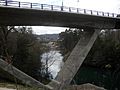
The Catholic church of the Good Shepherd opened on October 9, 2010. Its shape looks like a Scallop shell. In 2011, a new bridge over the Lérez River opened. This bridge connects the neighborhood to the civil parish of Lérez and the monastery of San Salvador de Lérez.
Since 2020, the Plaza de Europa park has a fun 20-meter long zip line. In May 2020, the city of Pontevedra created a Metrominuto map for the neighborhood. This map shows walking distances between places.

What is Monte Porreiro Like Today?
Monte Porreiro is a neighborhood on the edge of Pontevedra. It stretches along the Lérez River. The streets in the neighborhood are named after countries in Europe. You'll find streets like France, Sweden, Denmark, and the United Kingdom. The main square is called Europe Square.
To the west, there is the Mirador Park. To the east, you'll find the UNED Park. Both of these parks used to be part of the old Villa Buenos Aires estate. The Lérez Beach is also very close to the neighborhood.
Important Places and Facilities
Monte Porreiro has many useful places. The regional center of the National University of Distance Education is here. It's called the UNED Associated Centre of Pontevedra.
For education, there's the Luis Seoane High School and the Marcos Portela School. Younger kids can go to the Fina Casalderrey Nursery School or the A Galiña Azul Nursery.
The neighborhood also has a health center and a church. For sports, there's a football and rugby field. The Pontevedra-Universidad railway station is also nearby.
Fun Events and Festivities
Every year, Monte Porreiro celebrates its neighborhood festivities. They usually happen around May 4th and 5th. These celebrations honor the patron saint of Monte Porreiro, who is called the Good Shepherd.
Gallery
-
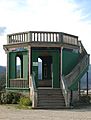
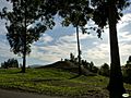
Mirador Park Lookout
-
Mirador Park
-
Buen Pastor church
-
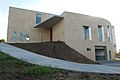
Local church
-
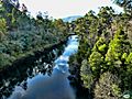
Lérez River
-
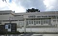
Headquarters of the National University for Distance Education
-
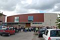
Gymkhana track
-
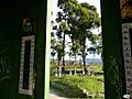
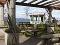
Pergola from inside the lookout point
-
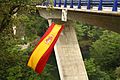
Word Bridge
-
Word Bridge

.jpg)


.jpg)

.jpg)
.jpg)
.jpg)
.jpg)
See also
 In Spanish: Monte Porreiro para niños
Related articles
- Word Bridge
- Valdecorvos
- UNED Associated Centre of Pontevedra
- Lérez River
