Monticello, Maine facts for kids
Quick facts for kids
Monticello, Maine
|
|
|---|---|

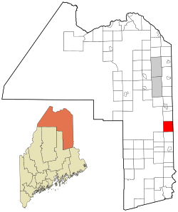
Location of Monticello, Maine
|
|
| Country | United States |
| State | Maine |
| County | Aroostook |
| Area | |
| • Total | 38.41 sq mi (99.48 km2) |
| • Land | 38.24 sq mi (99.04 km2) |
| • Water | 0.17 sq mi (0.44 km2) |
| Elevation | 561 ft (171 m) |
| Population
(2020)
|
|
| • Total | 737 |
| • Density | 19/sq mi (7.4/km2) |
| Time zone | UTC−5 (Eastern (EST)) |
| • Summer (DST) | UTC−4 (EDT) |
| ZIP code |
04760
|
| Area code | 207 |
| FIPS code | 23-46685 |
| GNIS feature ID | 0582604 |
Monticello is a town in Aroostook County, Maine, United States. It is located on the northern branch of the Meduxnekeag River. In 2020, about 737 people lived there.
Contents
History of Monticello
Monticello was first known as Wellington Township. It was settled in 1830 by General Joel Wellington, who owned the land. The town officially became a town in 1846.
The Amerisee People
Some of the first people who worked in Monticello were called the “Amerisee.” This group was made up of people from all five Wabanaki Maine tribes. They traveled together as seasonal workers, moving from place to place for jobs. Many of them settled in Monticello and other areas of Aroostook County.
The word “Amerisee” comes from the Mi’kmaq word “Amase’jijg.” This means “some distance” or “quite far.” It describes the long distances they traveled for work, often going across Canada and into Aroostook County, Maine.
The Matthew(s) family is an example of an Amerisee family. They are listed in the 1900 Census for Monticello, Maine. They hoped to create a sixth tribe that would welcome members from all five original tribes. These five tribes were once one group, but they were split apart due to colonization. The Amerisee wanted to bring them back together. However, this effort did not succeed, and the Amerisee tribal members later rejoined their original tribes.
John Matthew (also spelled Mathieu, Mathew, and Matthews) was listed in the 1900 Census. He said he was “Amerisee,” but his parents were both Mi’kmaq. His children were Frank, Lizzie, and Annie (Anastasia) Matthew. John Matthew also made baskets. His death record shows he was born in “Restigouche Ind.” territory. This shows how far these families traveled to find farm work in places like Monticello. John Matthew and other families like his are an important part of Monticello's history of seasonal and farm work.
WBCQ Radio Station
The international shortwave radio station WBCQ is also located in Monticello.
Geography of Monticello
Monticello is a town with a total area of about 38.41 square miles (99.48 square kilometers). Most of this area, about 38.24 square miles (99.04 square kilometers), is land. The rest, about 0.17 square miles (0.44 square kilometers), is water. This information comes from the United States Census Bureau.
Population of Monticello
| Historical population | |||
|---|---|---|---|
| Census | Pop. | %± | |
| 1850 | 227 | — | |
| 1860 | 483 | 112.8% | |
| 1870 | 760 | 57.3% | |
| 1880 | 965 | 27.0% | |
| 1890 | 1,132 | 17.3% | |
| 1900 | 1,332 | 17.7% | |
| 1910 | 1,297 | −2.6% | |
| 1920 | 1,268 | −2.2% | |
| 1930 | 1,467 | 15.7% | |
| 1940 | 1,504 | 2.5% | |
| 1950 | 1,284 | −14.6% | |
| 1960 | 1,109 | −13.6% | |
| 1970 | 1,072 | −3.3% | |
| 1980 | 950 | −11.4% | |
| 1990 | 872 | −8.2% | |
| 2000 | 790 | −9.4% | |
| 2010 | 790 | 0.0% | |
| 2020 | 737 | −6.7% | |
| U.S. Decennial Census | |||
In 2010, the town had 790 people living there. There were 343 households, which are groups of people living in the same home. About 224 of these were families. The population density was about 20.7 people per square mile (8.0 people per square kilometer).
The average age of people in Monticello in 2010 was 47.1 years old. About 18% of the people were under 18 years old.
Notable People from Monticello
- Donald Ardell – a person who served in the state government.
- William Coperthwaite – an educator and someone who promoted yurts (round tents). He was born in Monticello.
- Ralph Good – a baseball pitcher who played for the Boston Doves. He was also born in Monticello.
See also
 In Spanish: Monticello (Maine) para niños
 | James B. Knighten |
 | Azellia White |
 | Willa Brown |

