Moombooldool, New South Wales facts for kids
Quick facts for kids MoombooldoolNew South Wales |
|
|---|---|

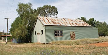
Public hall at Moombooldool
|
|
| Population | 30 (2016 Census) |
| Postcode(s) | 2665 |
| Elevation | 158 m (518 ft) |
| Location |
|
| LGA(s) | Narrandera Shire |
| Region | Riverina |
| County | Cooper |
| State electorate(s) | Cootamundra |
| Federal Division(s) | Riverina |
Moombooldool is a small village in the central northern part of the Riverina region in New South Wales, Australia. It is located on the Burley Griffin Way, a main road that connects different towns.
The village is about 9 kilometres east of Barellan. It is also 12 kilometres west of Kamarah. Moombooldool is roughly 420 kilometres away from both Sydney and Melbourne. This distance is "as the crow flies," meaning a straight line.
Contents
History of Moombooldool
Moombooldool has a history tied to its services and transport. These services helped the community grow over time.
Post Office Services
The Moombooldool Post Office first opened its doors on 15 April 1912. It served the local community for many years. People used it to send letters and parcels. The post office closed in 1982.
Railway Connections
A railway line reached Moombooldool in 1908. This was the Temora-Roto railway line. The railway station in Moombooldool closed in 1975. However, the railway tracks are still used today. Goods trains continue to travel along this line. They carry important supplies and products.
Location and Area
Moombooldool is part of the Narrandera Shire. This is a local government area in New South Wales. The village is also within the Riverina region. This area is known for its farming and agriculture.
Nearby Towns
Moombooldool is close to several other towns. It is about 62 kilometres east of Griffith. Narrandera is 68 kilometres to the north. Barellan is only 10 kilometres to the east. These connections help link Moombooldool to larger centres.
 | Aurelia Browder |
 | Nannie Helen Burroughs |
 | Michelle Alexander |


