Moore Park Beach, Queensland facts for kids
Quick facts for kids Moore Park BeachMoore Park, Queensland |
|||||||||||||||
|---|---|---|---|---|---|---|---|---|---|---|---|---|---|---|---|

Moore Park Beach
|
|||||||||||||||
| Population |
|
||||||||||||||
| • Density | 48.98/km2 (126.9/sq mi) | ||||||||||||||
| Postcode(s) | 4670 | ||||||||||||||
| Area | 59.0 km2 (22.8 sq mi) | ||||||||||||||
| Time zone | AEST (UTC+10:00) | ||||||||||||||
| Location |
|
||||||||||||||
| LGA(s) | Bundaberg Region | ||||||||||||||
| State electorate(s) | Burnett | ||||||||||||||
| Federal Division(s) | Flynn | ||||||||||||||
|
|||||||||||||||
|
|||||||||||||||
Moore Park Beach is a lovely coastal town located in Queensland, Australia. It's part of the Bundaberg Region and is known for its beautiful sandy beach along the Coral Sea. In 2021, about 2,890 people called Moore Park Beach home. It's a great spot for families and anyone who loves the beach!
Contents
Exploring Moore Park Beach
Moore Park Beach is right on the Coral Sea. It's about 23.4 kilometers (14.5 miles) north of the city of Bundaberg. The Kolan River forms its northern border.
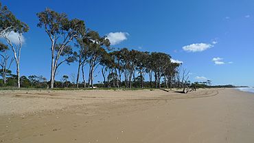
The town has a long, sandy beach that stretches along the entire coastline. This beach is perfect for swimming, playing, and enjoying the sun.
Natural Wonders
The northern part of Moore Park Beach is home to the Mouth of Kolan River Conservation Park. This special park covers 784 hectares (about 1,937 acres). It helps protect the natural environment around the river mouth.
Most of the land in Moore Park Beach is used for farming. Farmers here mainly grow sugarcane. There are also areas with houses, some close to the beach and others with larger properties further west.
A Glimpse into History
Moore Park Beach got its name on January 3, 1961. It was named after Isaac Moore, a grazier (someone who raises livestock) from Barambah station.
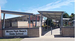
Moore Park Beach State School opened its doors on January 1, 2004. It's been helping kids learn and grow ever since!
Who Lives Here?
In 2021, the population of Moore Park Beach was 2,890 people. This number has grown over the years, showing that more and more people are choosing to live in this beautiful coastal area.
Learning and Schools
Moore Park Beach State School is a primary school for students from Prep to Year 6. It's located at 14 Murdochs Linking Road. In 2018, the school had 193 students.
If you're looking for a high school, there isn't one right in Moore Park Beach. The closest government high school is Bundaberg North State High School in North Bundaberg.
Fun Things to Do
Moore Park Beach has several parks where you can relax and play:
- Environmental Reserve Park
- Fauna And Flora Park
- Merv Thiele Park
- Moore Park Oval
- Moore Park Wetlands Reserve
- Ray Townson Park
- Royal Palms Estate Park
Beach Activities
If you love adventure, you can go four-wheel driving on two sections of the beach. There are special access points for this fun activity.
The Moore Park Surf Lifesaving Club is located on Surf Club Drive. These amazing volunteers patrol the beach to make sure everyone stays safe while swimming.
The beach is also a very important place for sea turtles. During the summer months, different types of sea turtles, including loggerhead sea turtles, come to the beach to lay their eggs. It's a truly special sight!
Getting Around
Moore Park Beach has a limited bus service run by Stewart & Sons. This helps people get around the area.
 | Victor J. Glover |
 | Yvonne Cagle |
 | Jeanette Epps |
 | Bernard A. Harris Jr. |


