
Mount Boucherie facts for kids
Quick facts for kids Mount Boucherie |
|
|---|---|

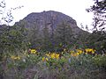
North face of Mount Boucherie.
|
|
| Highest point | |
| Elevation | 758 m (2,487 ft) |
| Prominence | 283 m (928 ft) |
| Listing | Mountains of British Columbia |
| Geography | |

Mount Boucherie
Location in British Columbia
|
|
| Parent range | Thompson Plateau |
| Geology | |
| Age of rock | Paleocene |
| Mountain type | Stratovolcano |
| Last eruption | Paleocene |
Mount Boucherie is a cool mountain in West Kelowna, British Columbia, Canada. It sits right across Okanagan Lake from the city of Kelowna. This mountain is actually what's left of an old stratovolcano that formed almost 60 million years ago! Over the last 50 million years, between four and six different ice ages have slowly worn down the volcano. Even though it's only about 417 metres (1,368 feet) above the lake now, scientists think it used to be much taller, maybe even 2,000 metres (6,562 feet) or more!
Contents
Why is it Called Mount Boucherie?
Mount Boucherie got its name from a man named Isadore Boucherie. He was a farmer and raised animals, and he was one of the first people to settle in the Rutland area and on the west side of Okanagan Lake. In the late 1880s, Isadore bought the land that is still known as Boucherie Ranch today. The mountain behind his ranch kept his name.
Interestingly, this mountain has had a few other names in the past:
- Mount Edgar: This name came from Edgar Dewdney, who used to be the Lieutenant-Governor of British Columbia. We don't know how often this name was used or when people stopped using it.
- Mount Bouchier or Bouchier Mountain: This was another way of saying Isadore Boucherie's name.
- Mount Boucherie: Some old records say it was named after an "E. Boucherie," not Isadore.
What is Mount Boucherie Made Of?

Mount Boucherie is mostly made of two types of volcanic rock: rhyolite and andesite. These rocks give the mountain its yellow, tan, and pinkish colors, especially on its north and south sides. The darker, black and gray parts on the east and northeast sides are made of a rock called dacite.
You can see large "columns" or "pipes" of rock on the mountain. These formed later in Mount Boucherie's volcanic history. We know this because these dacite columns cut through the older rhyolite and andesite rocks. The tall cliff face on the east side, above the valley, is made of folded layers of dacite rock that flowed out of the volcano.
About 60 million years ago, the area where Mount Boucherie is now was very active with earth movements. The landscape back then probably looked very different, with lots of volcanoes erupting and cracks forming in the Earth's crust.
Exploring Mount Boucherie's Parks
Mount Boucherie is a great place to explore, with parks that let you hike and enjoy nature.
Mount Boucherie Regional Park
Mount Boucherie Regional Park is a large area, covering about 36.4 hectares (90 acres). Most people access this park through a smaller park called Eain Lamont Community Park.
Eain Lamont Community Park
Eain Lamont Community Park is about 2.54 hectares (6.28 acres) in size. You can find it on Lakeview Cove Place. This park is where many trails start, whether you want to hike to the top of Mount Boucherie or walk around its base.
The 1992 Forest Fire
On the evening of May 7, 1992, a forest fire started by accident. Two 11-year-old boys were playing with matches behind Mount Boucherie Secondary School. This fire caused about 100 people to leave their homes for safety. The blaze burned about 60 hectares (148 acres) of forest on the steep north and east sides of Mount Boucherie. Luckily, no houses were destroyed. It cost about $170,000 to put out the fire.
Images for kids
-
Looking up at the east face of Mount Boucherie.
-
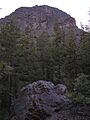
Another view of the east face, with a broken column of crystalline dacite in the foreground.
-
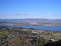
From the top east ridge, looking over Okanagan Lake towards Kelowna.


