Mount Haley Township, Michigan facts for kids
Quick facts for kids
Mount Haley Township, Michigan
|
|
|---|---|

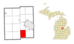
Location within Midland County and the state of Michigan
|
|
| Country | United States |
| State | Michigan |
| County | Midland |
| Area | |
| • Total | 23.87 sq mi (61.8 km2) |
| • Land | 23.82 sq mi (61.7 km2) |
| • Water | 0.05 sq mi (0.1 km2) |
| Elevation | 666 ft (203 m) |
| Population
(2020)
|
|
| • Total | 1,609 |
| • Density | 67.6/sq mi (26.1/km2) |
| Time zone | UTC-5 (Eastern (EST)) |
| • Summer (DST) | UTC-4 (EDT) |
| ZIP Codes | |
| Area code(s) | 989 |
| FIPS code | 26-111-55940 |
| GNIS feature ID | 1626773 |
Mount Haley Township is a special kind of local government area called a civil township. It's located in Midland County, which is part of the U.S. state of Michigan. In 2020, about 1,609 people called Mount Haley Township home.
Contents
Geography of Mount Haley Township
Mount Haley Township is found in the southern part of Midland County. Its southern border touches Saginaw County. The township covers a total area of about 23.9 square miles (about 62 square kilometers). Most of this area is land, with only a tiny bit, about 0.05 square miles, being water.
Communities in Mount Haley Township
Gordonville: A Historic Settlement
Gordonville was once a small community in Mount Haley Township. It started around a mill that made shingles (a type of roof tile).
Gordonville had its own post office. It first opened in 1875 with a funny name: Headache. Later that same year, its name was changed to Bradford. Finally, in 1906, the post office was renamed Gordonville. It stayed open until 1910.
Population and People
| Historical population | |||
|---|---|---|---|
| Census | Pop. | %± | |
| 1880 | 223 | — | |
| 1890 | 444 | 99.1% | |
| 1900 | 683 | 53.8% | |
| 1910 | 685 | 0.3% | |
| 1920 | 665 | −2.9% | |
| 1930 | 613 | −7.8% | |
| 1940 | 732 | 19.4% | |
| 1950 | 883 | 20.6% | |
| 1960 | 1,085 | 22.9% | |
| 1970 | 1,262 | 16.3% | |
| 1980 | 1,586 | 25.7% | |
| 1990 | 1,656 | 4.4% | |
| 2000 | 1,654 | −0.1% | |
| 2010 | 1,678 | 1.5% | |
| 2020 | 1,609 | −4.1% | |
| U.S. Decennial Census | |||
Let's look at how many people have lived in Mount Haley Township over the years. According to the census from 2010, there were 1,678 people living here. These people lived in 616 different homes, and 468 of those were families.
The population density was about 69.5 people per square mile. This means that, on average, about 70 people lived in each square mile of the township. There were also 641 housing units, which are places where people can live.
Most of the people in the township were White (about 97.88%). A smaller number of people were Native American, Asian, or from other backgrounds. About 0.91% of the population identified as Hispanic or Latino.
In 2000, the average household had about 2.69 people. The average family had about 3.09 people. The median age of people in the township was 36 years old. This means half the people were younger than 36, and half were older.
See also
 In Spanish: Municipio de Mount Haley para niños
 | William L. Dawson |
 | W. E. B. Du Bois |
 | Harry Belafonte |


