Mount Hillers facts for kids
Quick facts for kids Mount Hillers |
|
|---|---|

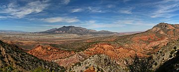
Mount Hillers at the core of the Henry Mountains
|
|
| Highest point | |
| Elevation | 10,741 ft (3,274 m) NAVD 88 |
| Prominence | 3,337 ft (1,017 m) |
| Isolation | 7.01 mi (11.28 km) |
| Parent peak | Mount Pennell (11,413 ft) |
| Naming | |
| Etymology | John Karl Hillers |
| Geography | |
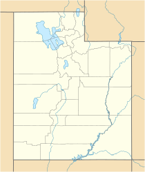
| Location | Garfield County, Utah, U.S. |
| Parent range | Henry Mountains |
| Topo map | USGS Cass Creek Peak |
| Geology | |
| Age of rock | Oligocene |
| Mountain type | Laccolith |
| Type of rock | Igneous |
| Climbing | |
| Easiest route | class 3 scrambling |
Mount Hillers is a tall mountain peak in the Henry Mountains range. You can find it in Garfield County, Utah, in the United States. This mountain stands very high, reaching about 10,741 feet (3,274 meters) into the sky!
It was named after John Karl Hillers, who was a government photographer. Almon Harris Thompson gave the mountain its name.
Weather at Mount Hillers
The best times to visit Mount Hillers are during spring and fall. The weather is usually just right for exploring then.
Climate Zone
Mount Hillers is in a "cold semi-arid climate" zone. This means the coldest month has an average temperature below 32 °F (0 °C). Also, more than half of the yearly rain and snow falls during spring and summer.
Rainfall and Snowfall
This desert climate does not get much rain, usually less than 10 inches (250 mm) each year. Snowfall in winter is generally light.
 | Janet Taylor Pickett |
 | Synthia Saint James |
 | Howardena Pindell |
 | Faith Ringgold |


