Mount Kembla facts for kids
Quick facts for kids Mount KemblaWollongong, New South Wales |
|||||||||||||||
|---|---|---|---|---|---|---|---|---|---|---|---|---|---|---|---|
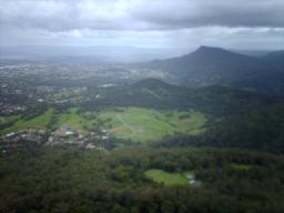
The suburb of Mount Kembla viewed from Mount Keira
|
|||||||||||||||
| Population | 1,083 (2021 census) | ||||||||||||||
| • Density | 677/km2 (1,750/sq mi) | ||||||||||||||
| Postcode(s) | 2526 | ||||||||||||||
| Elevation | 534 m (1,752 ft) | ||||||||||||||
| Area | 1.6 km2 (0.6 sq mi) | ||||||||||||||
| LGA(s) | City of Wollongong | ||||||||||||||
| State electorate(s) | Wollongong | ||||||||||||||
| Federal Division(s) | Cunningham | ||||||||||||||
|
|||||||||||||||
| Mount Kembla | |
|---|---|
| Hat Hill | |
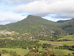
View of Mount Kembla from Mount Nebo
|
|
| Highest point | |
| Elevation | 534 m (1,752 ft) |
| Geography | |
| Location | Illawarra region, New South Wales, Australia |
Mount Kembla is a suburb and a mountain in the Illawarra region of New South Wales, Australia.
The suburb is a small, semi-rural town near Wollongong. It gets its name from the mountain. The word kembla comes from an Aboriginal language and means "plenty of game". The mountain is part of the Illawarra escarpment.
Mount Kembla suburb includes smaller areas like Kembla Heights and Cordeaux Valley. In 2021 census, about 1,083 people lived here. The top of Mount Kembla mountain is 534 metres (1,752 ft) above sea level. This area is known for coal mining. It is also famous for the Mount Kembla Mine disaster in 1902, where 96 people lost their lives.
Contents
Mount Kembla Suburb and Village
The village of Mount Kembla is part of the larger suburb. It has a local primary school and a church with a graveyard. You can also find the Mount Kembla Hotel, which was built in 1896. The general store and post office closed in 2010. This was the first time in 145 years the village did not have one.
The village also has a heritage centre. It shows the local history, especially about the mining disaster. Every year since the disaster, there has been a Heritage Festival. There is also a "96 Candles Ceremony" to remember the victims. You can reach the village from Wollongong by Cordeaux Road. You can also get there from Mount Keira using Harry Graham Drive.
The Mount Kembla Colliery (coal mine) started in 1883. The mining company built the town for its workers. The community did well until the mine closed in the late 1970s. After that, the town became quieter. It lost its general store, post office, and other facilities.
Today, South32 still mines at the Dendrobium site. This site is about half a kilometre west of the village. Mount Kembla is connected to the Illawarra escarpment to the west. It has two lower peaks nearby: Kembla West (512 m) and Mount Burelli (531 m). The mountain stands out, pointing towards the east.
Mount Kembla Mine Disaster
On July 31, 1902, the Mount Kembla Colliery exploded. This terrible event killed 96 men and boys. The Mount Kembla Mine disaster was one of Australia's worst peacetime disasters. Only Cyclone Mahina and the 2009 Black Saturday bushfires caused more deaths.
The Mine's Layout
The Mount Kembla mine dug into the Bulli coal seam. This seam was about 800 feet (240 m) above sea level on the side of Mount Kembla. Miners worked through a main tunnel that went into the mountain. There were also smaller tunnels for air and water.
The main tunnel went northwest from the entrance. Another important tunnel, "No. 1 Right," branched off the main tunnel. It went north. Smaller paths branched off No. 1 Right. The explosion happened in the "Eastern District," at the end of No. 1 Right.
At first, air moved through the mine using a furnace at the entrance. Later, a new air shaft was dug. This shaft went over 400 feet (120 m) down to a special area. A furnace at the bottom of this shaft helped move air. The old air paths then became ways for miners to walk.
Before the disaster, the mine manager said the mine was "absolutely without danger from gases." Local newspapers also reported that gas had "never been known to exist" there. They called it "one of the best ventilated mines in the State."
However, a special investigation (Royal Commission) found something different. The mine was in the same coal seam as the Bulli Colliery. Bulli had a gas and coal-dust explosion in 1887 that killed 81 people. The commission found many reports of gas in the Mount Kembla mine. They even tested parts of the mine themselves and found gas. They realized that dangerous gas could build up almost anywhere.
About 270 acres (110 ha) of the mine's 769 acres (311 ha) had already been dug out. These empty spaces were called "goafs." When wooden supports were removed, the roof would fall into these goafs.
What Happened During the Disaster
Around 2:00 PM on July 31, 1902, a loud noise was heard. A lot of flame and smoke burst from the main tunnel. Smoke also came out of other tunnels. There were 261 men underground at the time. Some managed to escape on their own after the blast.
The Royal Commission found out how the disaster happened. A part of the roof fell in the 4th Right goaf. This pushed out a lot of gas mixed with air. This mixture traveled along a path, picking up coal dust. It then burst into another tunnel.
As the mixture moved, it was pushed back by the mine's air current. Some of the gas went ahead. It met a miner's open flame light at a junction. The gas caught fire and flashed back to the main cloud of gas. The gas, coal-dust, and air mixture then exploded. The force of this explosion caused more coal dust to explode. This continued until flames came out of the mine entrance.
The explosions badly damaged a large part of the mine. Some miners died from the blast. But most deaths were caused by carbon monoxide, also called "after-damp." This deadly gas formed because the coal dust did not burn completely.
Luckily, the area with the ventilation furnace was not hit by the explosion. The furnace kept pulling air through the mine. This helped clear the after-damp. Rescuers could enter the mine as the air cleared. They faced challenges from fallen rocks. Sadly, two rescuers, Mr. H. O. MacCabe and William McMurray, went too fast and died from the after-damp.
Investigations and Findings
An investigation started the day after the explosion. It lasted for 22 days, hearing from many witnesses. The jury decided that the miners died from carbon monoxide poisoning. They believed it was caused by a gas explosion. This explosion was lit by open flame lights used in the mine. They also said that a series of coal-dust explosions made it worse.
A special Royal Commission was set up later in 1902. It held more hearings in 1903. This commission had a slightly different view. They believed the coal-dust explosions were part of the first blast, not something that happened later. They also thought the explosion started in a different part of the mine.
The commission concluded that gas was pushed out from a falling roof. They looked into whether anyone was to blame. Mine rules said that waste areas should be checked weekly. This was not being done. Also, no one seemed to be testing for gas. The commission decided that even with normal checks, the gas build-up might not have been found.
The commission did not blame any single person. Instead, they said that using safety lamps instead of open flame lights could have saved lives. However, open flame lights continued to be used in mines until the 1940s.
Remembering the Victims
Some of the miners who died were buried in Mount Kembla's village cemetery. There is a 2.5-metre (8 ft 2 in)-tall memorial there. It lists the names of the 96 miners and two rescuers who died. Most victims were buried in the Windy Gully cemetery. This cemetery is about 1.5 kilometres (0.93 mi) southwest of the village. An annual memorial ceremony is held there during the Mount Kembla Mining Heritage Festival. This festival happens on the weekend after July 31st each year.
History of Mount Kembla
Local Aboriginal stories tell that Mount Kembla and Mount Keira were sisters. The Five Islands were their daughters, born from the wind. The first European to see the mountain was Captain James Cook. He saw it during his voyage along Australia's east coast. He described it as a "round hill" that looked like a hat. The village was first settled in 1817 by George Molle.
You can still see two old watering holes for pit ponies on the ring track. There are also remains of a road that was meant to go to the top of the mountain. This road was started in the 1800s but never finished. On the eastern part of the Ring Track, you can find two old mine entrances.
Mount Kembla has played a big part in the mining industry. It was home to Australia's first kerosene mine. This mine started in 1865 near American Creek. Coal mining has been the main industry and continues today with the Dendrobium Mine.
Besides mining, Mount Kembla has a rich farming history. The Cordeaux Valley area was once famous for growing fruit. It was one of Australia's best apple producers. Apples from here were even sent to London.
Notable People from Mount Kembla
Mount Kembla is known for attracting creative people. Painters, poets, writers, and photographers find inspiration here. Some notable people include:
- Wendy Richardson OAM, a playwright who writes plays.
- John McNamara OAM, a poet and historian who writes poems and studies history.
- Fred Moore, a miner and activist who worked to help others.
Geography of Mount Kembla
Mount Kembla is connected to the sandstone cliffs of the Illawarra escarpment. It looks over Wollongong. The top of the mountain is 534 metres (1,752 ft) above sea level. It is a well-known landmark in the area. There is a lookout at the top, connected to a 5.5-kilometre (3.4 mi) walking track.
The mountain has a special mix of plants. It is where northern and southern types of eucalypt trees meet. It also has many kinds of rainforest plants. There are two orchards on the western side of the mountain. American Creek flows down the mountain, past the mine and village.
Mount Kembla is mostly made of sandstone. It forms a ridge that goes from the escarpment about 2 kilometres (1.2 mi) to its east. The top of the mountain has two flat areas, or plateaus. The higher one is slightly raised. The ridge gets thinner at the top and wider below. This creates foothills that reach into the outer western suburbs of Wollongong and Unanderra. Many tall trees grow here. Small patches of rainforest are found near Dapto Creek and American Creek. American Creek flows north of the mountain, and Dapto Creek flows from the south. A noticeable foothill sticks out on the southeast side, above farmland.
Mount Kembla is part of the Illawarra Escarpment State Conservation Area. This area stretches from Stanwell Park in the north to Wongawilli in the south. The NSW National Parks & Wildlife Service manages this conservation area.
Flora and Fauna
Flora (Plants) on Mount Kembla
The plants on Mount Kembla include blackwood trees and native peach. You can also find bastard rosewood, native cucumber, and sandpaper fig trees. Other plants are Moreton Bay fig, native ginger, native raspberries, and hibiscus. Some rare local plants include white beech and Bangalow palm.
Fauna (Animals) on Mount Kembla
Animals living on Mount Kembla include swamp wallabies, deer, and spotted-tailed quolls. You might also see southern brown bandicoots, grey-headed flying foxes, and sugar gliders. Wombats and possums are also present.
Frogs like giant burrowing frogs, red-crowned toadlets, and striped marsh frogs live here. Reptiles include eastern water dragons, water skinks, and blue-tongued lizards. Snakes like diamond pythons, red-bellied black snakes, and golden-crowned snakes are also found, but they are not commonly seen.
Many birds live on the mountain. Common birds are lyrebirds, spotted turtle doves, and kookaburras. You can also spot satin bower birds, superb blue wrens, and crimson rosellas. King parrots, white-headed pigeons, and brown cuckoo-doves are also seen. Other birds include silvereyes, eastern yellow robins, and rainbow lorikeets.
In 1804, a logrunner bird was found on Mount Kembla. This was the first time this bird was described by scientists. While some sources say brush turkeys are common, they are not often seen here.
The first scientific discovery of the koala in Australia happened at Mount Kembla. This was between June and August 1803. Koala specimens were collected and taken to Sydney. There, they were drawn by Ferdinand Bauer and described by Robert Brown. Koalas likely disappeared from the area over time. This was due to forests being cleared by settlers. They were definitely gone after a big fire in 1909. The last possible sighting of a koala was in 1919.
Walking Tracks on Mount Kembla
Mount Kembla has several walking tracks for you to explore.
Mount Kembla Ring Track
The Mount Kembla Ring Track goes around the mountain. It starts from the Kembla Lookout carpark on Cordeaux Road. You go down stone steps into a gully that leads to Dapto Creek. The track then follows the southern side of the mountain. You will walk through palm and fern plants.
At a junction, you will find one of two old pit pony watering holes. If you turn left, you will go north to the second watering hole and an old mine entrance. Another path leads to another mine entrance. Both mine entrances are closed because the tunnels could collapse. From here, the track goes through more open forest. It then comes out at Cordeaux Road. To finish the walk, you walk up the road back to the lookout. This walk is usually done by going anti-clockwise. You might see deer, wallabies, and sometimes snakes or wild goats.
Mount Kembla Summit Track
The Mount Kembla Summit Track starts in the same dry bush area as the Ring Track. After an information stand, it turns left. This track climbs slowly up the mountain's ridge. It goes onto two flat areas at the top, called plateaus. Finally, it reaches the trigonometry station at the very top.
Both plateaus are narrow and run east to west along the ridge. Signs warn about "crumbling edges," but the track is well-maintained. This makes it easy to reach the top. To the left (north) of this track, there is an old road. It was built in the late 1800s but never finished. It is still visible but overgrown. Halfway along the track, there are several rock lookouts. From here, you can see great views to the south and west. The summit offers views from northeast to southeast. You might often see lyrebirds, pigeons, and sometimes wild turkeys.
Bridle Track
The Bridle Track starts on the west side of the Cordeaux Road carpark at the Kembla Lookout. This track used to be for horses. It is now quite overgrown in places. It follows along the escarpment, just below the edge. It can be very slippery when wet. Some parts require jumping from rock to rock. However, most of it is still walkable if you are careful. The track goes through Illawarra rainforest. Lyrebirds and swamp wallabies are common here. This track used to go all the way to the Unanderra - Moss Vale railway line. Now, it is overgrown after a few hundred metres.


