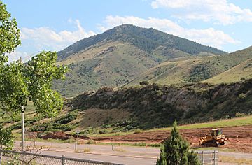
Mount Morrison (Colorado) facts for kids
Quick facts for kids Mount Morrison |
|
|---|---|

Mount Morrison as seen from I-70
|
|
| Highest point | |
| Elevation | 7,881 ft (2,402 m) |
| Prominence | 741 ft (226 m) |
| Isolation | 4.59 mi (7.39 km) |
| Geography | |
| Location | Jefferson County, Colorado, U.S. |
| Parent range | Front Range |
| Topo map | USGS 7.5' topographic map Morrison, Colorado |
| Climbing | |
| Easiest route | hike |
Mount Morrison is a special hill, or "foothill," found on the eastern side of the Front Range. This Front Range is part of the huge Rocky Mountains in North America.
This peak stands about 7,881 feet (or 2,402 meters) tall. It is located inside Red Rocks Park. You can find it about 3.0 kilometers (or 1.9 miles) northwest of the Town of Morrison. This area is in Jefferson County, Colorado, in the United States.
A very famous place called Red Rocks Amphitheatre is built right on the eastern side of Mount Morrison.
Exploring Mount Morrison
Mount Morrison is not as tall as some of the giant mountains in the Rockies. However, it is an important part of the landscape. It acts like a natural gateway to the higher mountains.
The mountain is a popular spot for hiking. Many people enjoy walking its trails. From the top, you can see amazing views of the surrounding area. This includes the nearby plains and the bigger mountains further west.
What is a Foothill?
A foothill is a low hill or a small mountain. It is usually found at the base of a larger mountain range. Think of it as a smaller step before you get to the really big steps (the tall mountains). Mount Morrison is a great example of a foothill.
Red Rocks Park and Amphitheatre
Mount Morrison is a key feature of Red Rocks Park. This park is famous for its giant, red sandstone rock formations. These rocks are very old and were formed over millions of years.
The Red Rocks Amphitheatre is a world-famous outdoor concert venue. It is built right into the natural rock formations on the eastern side of Mount Morrison. The unique design uses the natural acoustics of the rocks. This makes it an amazing place to listen to music.
- The amphitheatre can hold many thousands of people.
- It is known for its beautiful scenery and clear sound.
- Many famous musicians have performed here.
The park and the amphitheatre are popular places for both locals and tourists. People come to hike, enjoy nature, and attend concerts.
 | Emma Amos |
 | Edward Mitchell Bannister |
 | Larry D. Alexander |
 | Ernie Barnes |


