Mount Moturau facts for kids
Quick facts for kids Mt Moturau |
|
|---|---|

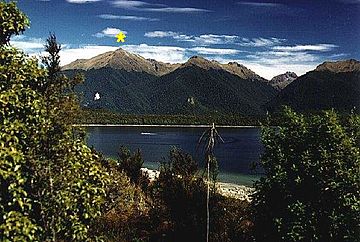
Mount Moturau, Lake Manapouri
|
|
| Highest point | |
| Elevation | 1,497 m (4,911 ft) |
| Prominence | 215 m (705 ft) |
| Geography | |
| Location | South Island, New Zealand |
| Topo map | 260-C44 |
| Climbing | |
| First ascent | J Calder |
| Easiest route | Bicycle Spur Trail |
Mount Moturau is a mountain located in the beautiful South Island of New Zealand. It stands tall at 1,497 meters (about 4,911 feet) and is a clear landmark visible from the town of Manapouri. This mountain rises southwest of the Hope Arm of Lake Manapouri, a famous lake known for its stunning scenery.
Exploring Mount Moturau
Mount Moturau is a significant peak in the Fiordland National Park area. Its impressive height makes it stand out in the landscape, especially when viewed from Lake Manapouri. For those who enjoy outdoor adventures, the "Bicycle Spur Trail" is known as an easier way to explore parts of the mountain's surroundings.
The Story Behind the Name
The name Moturau has a rich history connected to the Māori people, the original inhabitants of New Zealand.
Moturau: A Name with Many Meanings
- Original Village Name: Long ago, Moturau was the Māori name for a summer village located where the town of Manapouri is today.
- Lake Manapouri Connection: Some stories suggest that Moturau was an older name for Lake Manapouri itself, highlighting its deep connection to the area.
- Modern Uses: Today, the name Moturau is still used for important things in the region. You might hear of a tourist boat on Lake Manapouri called Moturau. There is also a hut named Moturau on the famous Kepler Track, a popular walking trail.
These different uses of the name show how important Moturau has been and still is to the history and culture of this part of New Zealand.
 | Ernest Everett Just |
 | Mary Jackson |
 | Emmett Chappelle |
 | Marie Maynard Daly |

