Mount Murchison, Queensland facts for kids
Quick facts for kids Mount MurchisonQueensland |
|||||||||||||||
|---|---|---|---|---|---|---|---|---|---|---|---|---|---|---|---|

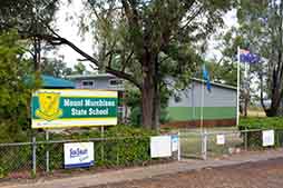
Mount Murchison State School, 2013
|
|||||||||||||||
| Population | 128 (2021 census) | ||||||||||||||
| • Density | 1.684/km2 (4.36/sq mi) | ||||||||||||||
| Postcode(s) | 4715 | ||||||||||||||
| Area | 76.0 km2 (29.3 sq mi) | ||||||||||||||
| Time zone | AEST (UTC+10:00) | ||||||||||||||
| Location |
|
||||||||||||||
| LGA(s) | Shire of Banana | ||||||||||||||
| State electorate(s) | Callide | ||||||||||||||
| Federal Division(s) | Flynn | ||||||||||||||
|
|||||||||||||||
Mount Murchison is a small country area in Queensland, Australia. It's part of the Shire of Banana. In 2021, about 128 people lived here.
Contents
What is Mount Murchison Like?
Mount Murchison is a rural area. This means it's mostly countryside with farms and open spaces. The Callide Power Station is located in the south-east part of the area. It's a very important place for making electricity.
A Look Back at Mount Murchison's Past
When Did the School Open?
Mount Murchison State School first opened its doors on 24 April 1935. The school was built for up to 24 students. It had one classroom and was made of timber. The first teacher was Reg Davidson.
The Story of Callide Power Station
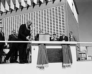
The Callide Power Station started working in 1965. It was officially opened by Frank Nicklin, who was the Premier of Queensland at the time. This opening happened on 21 August 1965.
In 2021, there was an incident at the power station. An explosion and fire happened on 25 May. This caused a large power outage. Over 375,000 homes and businesses lost electricity.
How Did the Library Service Start?
A mobile library service began in Mount Murchison in 2004. This service brings books and other materials to the community.
Who Lives in Mount Murchison?
The number of people living in Mount Murchison has changed over the years.
- In 2011, there were 226 people.
- In 2016, the population was 149 people.
- By 2021, the population was 128 people.
How Does Mount Murchison Make Money?
The Role of Callide Power Station
The main part of Mount Murchison's economy is the Callide Power Station. This station uses coal to make electricity. It has eight large machines called steam turbines. Together, they can produce a lot of power. In 2018, it could make 1,510 megawatts of electricity.
Learning in Mount Murchison
Mount Murchison State School
Mount Murchison State School is a government primary school. It teaches students from Prep (the first year of school) up to Year 6. The school is for both boys and girls. In 2013, it had 16 students in one class. By 2018, there were 33 students.
Where Do Older Students Go to School?
There isn't a high school in Mount Murchison itself. Students who are older usually go to Biloela State High School. This school is in the nearby town of Biloela.
What Can You Do in Mount Murchison?
Mobile Library Service
The Banana Shire Council runs a mobile library service. This library visits the school every two weeks. It's a great way for students and families to get books.
Stoneyridge Raceway
If you like motorsports, the Biloela Dirt Riders group has a place called Stoneyridge Raceway. It's located on Cocups Road.
 | William Lucy |
 | Charles Hayes |
 | Cleveland Robinson |


