Mount Nebo (New South Wales) facts for kids
Quick facts for kids Mount Nebo |
|
|---|---|

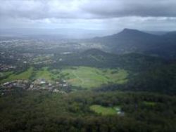
Mount Nebo in the foreground, seen from Mount Keira. Mount Kembla is visible in the background.
|
|
| Highest point | |
| Elevation | 251 m (823 ft) |
| Geography | |
| Location | Illawarra region, New South Wales, Australia |
| Parent range | Illawarra Range |
Mount Nebo is a hill in New South Wales, Australia. It's part of the Illawarra Range, which is a big mountain ridge. This hill is near the city of Wollongong. Mount Nebo is about 251 meters (823 feet) high. You can get there by a steep road called O'Brien's Road, starting from the suburb of Figtree.
Contents
Exploring Mount Nebo's History and Views
Mount Nebo offers amazing views of the surrounding area. From the top, you can see the city of Wollongong, Lake Illawarra, and other local mountains. The name "Nebo" comes from the Aboriginal people, who are the original inhabitants of Australia. They named this hill, and the name has stayed the same, just like for other places such as Woonona Mountain.
O'Brien's Road: A Path Through Time
O'Brien's Road was built a long time ago, in the early 1800s. It was a private road where people had to pay a fee to use it. This road helped connect Sydney to the Illawarra region. The road started near a famous fig tree, which is how the nearby suburb of Figtree got its name.
In 1999, the local council closed the road to cars past the summit. This was because some people were illegally dumping trash there. Now, the road is mostly a walking track. Even though cars can't go all the way, litter can still be a problem.
Stunning Scenery and Photography Spots
Mount Nebo is a great place to take photos. You can get clear views of other mountains like Mount Kembla and Mount Keira. The hill is connected to the main Illawarra escarpment by a path called Nebo Ridge.
Near the top of the hill, you'll find television towers and a water tank. From this spot, you can see the Illawarra Coastal Plain. You might also spot smaller hills like Mount Mangerton and Mount Saint Thomas among the houses. To the southeast, you can see Saddleback Mountain and the Knights Hill.
Walking Tracks and Nature at Mount Nebo
There are several tracks around Mount Nebo for walking and even horse riding. One track goes from near the summit, along Nebo Ridge. This ridge has its own high point with more views of Mount Keira and Mount Brisbane.
Wildlife and Plants
When you explore Mount Nebo, you might see different kinds of birds, snakes, and plants. However, there are also some plants and animals that are not native to the area, like deer and a plant called Lantana, which can cause problems for the local environment.
Connecting Trails
The walking track can be quite steep in one part, climbing about 100 meters (328 feet). It then goes along the side of Pupiana, which is part of Mount Brisbane. The track also passes a waterfall and some old water pipes. Eventually, it leads to Harry Graham Drive, which is a scenic route along the escarpment. From there, you can easily reach other tracks like the Motocross Track.
Mount Nebo's Surroundings
Some parts of Mount Nebo, especially on the east and south sides, have houses built close to them. The southwest slopes are used for farming. In the valley to the southwest, there's an old coal mine called Mount Nebo Colliery. Its name comes from two other local mountains, Mount Kembla and Mount Keira.
The old road on Mount Nebo is still used by people for walking, jogging, and watching birds. Even though some parts of the road are crumbling, it's still a popular spot for outdoor activities.


