
Mount Nyiragongo facts for kids
Quick facts for kids Mount Nyiragongo |
|
|---|---|

Mount Nyiragongo viewed aerially in 2014
|
|
| Highest point | |
| Elevation | 3,470 m (11,385 ft) |
| Prominence | 1,443 m (4,734 ft) |
| Listing | Ribu |
| Geography | |

Mount Nyiragongo
Location in Democratic Republic of the Congo
|
|
| Location | Democratic Republic of the Congo |
| Parent range | Virunga Mountains |
| Geology | |
| Formed by | Volcanism along the Albertine Rift |
| Mountain type | Stratovolcano |
| Last eruption | 22 February 2024 – present |
Mount Nyiragongo (pronounced neer-uh-GONG-go) is an active volcano in the Democratic Republic of the Congo. It stands tall at about 3,470 meters (11,385 feet) in the Virunga Mountains. This amazing volcano is part of Virunga National Park, close to the city of Goma and Lake Kivu. It is also near the border with Rwanda.
The top of Mount Nyiragongo has a huge crater, about 2 kilometers (1.2 miles) wide. Inside this crater, you can often find a bubbling lava lake. This lava lake has sometimes been the biggest known lava lake in the world! The depth of the lava lake changes a lot. Before an eruption in 1977, it was about 600 meters (1,969 feet) deep. After another eruption in 2002, it was much lower, about 900 meters (2,953 feet) below the rim. Since then, the lava level has slowly gone up. Mount Nyiragongo and its neighbor, Nyamuragira, have caused 40% of all volcanic eruptions recorded in Africa.
Contents
Understanding Nyiragongo's Geology

Mount Nyiragongo is built on top of parts of two older volcanoes, Baruta and Shaheru. Around it, you can see hundreds of smaller volcanic hills called cinder cones. These cones formed from past eruptions on the volcano's sides.
The main cone of Nyiragongo is made of volcanic ash, rocks, and hardened lava. The lava from Nyiragongo is special. It has very little silica, which is a common mineral in many rocks. This makes the lava very runny, almost like water! Most lava flows move slowly, but Nyiragongo's lava can rush down the mountain at speeds of up to 100 kilometers per hour (60 miles per hour). This makes its eruptions very dangerous because the lava moves so fast.
Exploring Nyiragongo's Eruption History
Scientists don't know exactly how long Mount Nyiragongo has been erupting. However, it has erupted at least 34 times since 1882. Many times, it was active for years, with a swirling lava lake inside its crater. People suspected a lava lake was there for a while. But it was only confirmed by scientists in 1948. Back then, the lake was measured to be very large. Later studies showed that the lake's size, depth, and temperature changed over time.
The lava lake is still active today. In 2020, the lake was mostly held within a wide, steep-sided cinder cone. This cone was about 18 meters (60 feet) high and 183 meters (600 feet) wide on the crater floor.
The 1977 Eruption: A Fast Lava Flow
From 1894 to 1977, Nyiragongo's crater held an active lava lake. On January 10, 1977, cracks appeared in the crater walls. The entire lava lake drained out in less than an hour! The lava rushed down the volcano's sides at speeds up to 60 kilometers per hour (37 mph). This was the fastest lava flow ever recorded at that time. It quickly covered nearby villages and caused many deaths in Kibati and Moniki.
The lava lake emptied in just 30 minutes. The fast-moving lava flowed to the north, south, and west of the volcano. Because Nyiragongo is so close to many towns, its eruptions can cause big natural disasters. The 1977 event showed how dangerous Nyiragongo can be. Because of this, in 1991, it was named a "Decade Volcano." This means it needs special study due to its history of large, destructive eruptions. Before this eruption, a new small vent called Murara had opened on the slopes of Nyamuragira.
The 2002 Eruption: Lava Reaches Goma
New lava lakes formed in the crater during eruptions in 1982–1983 and 1994. Another big eruption started on January 17, 2002. This happened after several months of increased earthquake activity and gas escaping from the volcano. A 13-kilometer (8-mile) crack, called a fissure, opened on the volcano's southern side. In just a few hours, this crack reached the edge of Goma, a major city on Lake Kivu.
Lava poured out from three small cones at the end of the crack. It flowed in a wide stream, up to 1,000 meters (3,281 feet) wide and 2 meters (7 feet) deep, right through Goma. Warnings helped 400,000 people evacuate from the city. They moved across the border into Gisenyi, Rwanda. The lava covered part of the runway at Goma International Airport and reached Lake Kivu. People worried that the lava could release dangerous gases like carbon dioxide and methane from the lake's depths. This had caused a disaster at Lake Nyos in Cameroon in 1986. Luckily, this did not happen at Lake Kivu. Scientists still watch the area very carefully.
The 2002 eruption caused many deaths due to dangerous gases and collapsing buildings. Lava covered 13 percent of Goma, leaving almost 120,000 people without homes. After the eruption stopped, many earthquakes shook Goma and Gisenyi for about three months. These tremors caused even more buildings to collapse. Six months later, the volcano erupted again.
Understanding Mazuku: Dangerous Gas Pockets
Sometimes, dangerous carbon dioxide gas collects in low-lying areas. This is known locally as 'mazuku'. This gas can harm animals and people, especially where it seeps from the ground in high amounts and there isn't enough wind to blow it away.
On March 8, 2016, the Goma Volcano Observatory found a new opening, or vent, on the northeast edge of the crater. This discovery followed reports from local people who heard rumbling sounds from the volcano. Some people worried this could lead to a side eruption. In 2020, scientists saw the lava lake rising and other signs that an eruption might happen soon.
The 2021 Eruption: Evacuations and Impact
An eruption happened on May 22, 2021, almost two decades after the last big eruption in 2002. Lava flowed towards the Goma airport and moved into the city center of eastern Goma. The N2 road was cut off by the lava. The military governor of North Kivu province confirmed the eruption started around 5:00 P.M. local time. A highway to Beni was also blocked by lava. Authorities told people in Goma to leave their homes, causing thousands to evacuate. Electricity was also cut off in many areas after the eruption. By May 27, 2021, many people went missing or died after a lava flow reached the city's outskirts. The eruption caused many deaths, mostly from car crashes during the evacuation.
Monitoring Nyiragongo's Activity

A team of scientists at the Goma Volcanic Observatory (GVO) constantly watches the volcano. They collect earthquake data every four minutes and temperature data every ten minutes. However, the future funding for the GVO is uncertain. The World Bank decided in 2020 to stop its financial support.
Images for kids
-
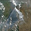
Satellite image of the eruption plume from Nyiragongo in July 2004
-
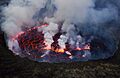
Mount Nyiragongo's lava lake


See also
- Decade Volcanoes
- List of volcanic eruptions by death toll
- List of volcanoes in the Democratic Republic of the Congo
