Mount Pisgah (Vermont) facts for kids
Quick facts for kids Mount Pisgah |
|
|---|---|

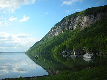
Mount Pisgah from the south, overlooking Lake Willoughby
|
|
| Highest point | |
| Elevation | 2,785 ft (849 m) |
| Geography | |
| Location | Northeast Kingdom, Vermont, U.S. |
| Topo map | USGS Mount Pisgah |
Mount Pisgah is a cool mountain located in Westmore, Vermont. It stands tall on the eastern side of Lake Willoughby. This mountain is a big part of the "Willoughby Gap" or "Willoughby Notch." It's also part of the beautiful Northeastern Highlands of Vermont. You can find awesome hiking trails here in Willoughby State Forest.
The steep cliffs of Mount Pisgah are home to special alpine plants. These plants are protected because there are no trails that go directly to them.
Contents
Explore Mount Pisgah: Hiking Adventures
If you love hiking, Mount Pisgah has some great trails for you! To start your adventure, look for the parking area. It's on the west side of Vermont Route 5A. You'll find it at the south end of Lake Willoughby. The actual trailhead is marked by a sign across the road.
Discover Pulpit Rock and Peregrine Falcons
After hiking about 1 mile (1.6 km), you'll reach a famous spot called Pulpit Rock. This area is a known nesting place for the amazing peregrine falcon. These birds are super fast! Pulpit Rock also gives you a fantastic view of Lake Willoughby.
There's even a special path from Pulpit Rock. It leads to a rock overhang that hangs 650 feet (198 m) above the lake. Imagine the view from there!
Reaching the Summit Views
Once you leave Pulpit Rock, the main trail moves away from the cliffs. It then climbs up to a viewing area. This spot is a large rock slab. From here, you can enjoy more incredible sights.
The Loop Trail and Lookout Spots
The main hiking trail continues along a ridge. It goes east, away from the lake, then curves back. This loop brings you right back to the parking area. As you walk down, the trail offers three different small lookout spots. Each one gives you a unique view of the area.
The entire hiking trail is about 2.5 miles (4 km) long. It climbs 1,590 feet (485 m) from the bottom to the highest point. It's a great way to get some exercise and see nature!
 | William L. Dawson |
 | W. E. B. Du Bois |
 | Harry Belafonte |


