
Lake Willoughby facts for kids
Quick facts for kids Lake Willoughby |
|
|---|---|

Looking south from above north shore of Lake Willoughby, with Mt. Pisgah distant left and Mount Hor distant right, courtesy of Nathaniel Broderick.
|
|

Lake Willoughby
Location in Vermont

Lake Willoughby
Location in the United States
|
|
| Location | Orleans County, Vermont, United States |
| Coordinates | 44°45′07″N 72°03′46″W / 44.75194°N 72.06278°W |
| Type | glacial lake (ice age) |
| Primary inflows | glacial aquifer. |
| Primary outflows | Willoughby River (creek) |
| Catchment area | Lake Memphramagog, Gulf of St. Lawrence, Atlantic Ocean |
| Basin countries | United States |
| Max. length | 5 miles (8.0 km) |
| Max. width | 1 mile (1.6 km) |
| Surface area | 1,687 acres (683 ha) |
| Average depth | 185 feet (56 m) |
| Max. depth | 328 ft (100 m) |
| Surface elevation | 1,171 ft (357 m) |
| Designated: | 1967 |
Lake Willoughby is a beautiful lake located in the town of Westmore, in Orleans County, Vermont, in the United States. It's part of a special area known as the Northeast Kingdom.
The southern part of the lake is surrounded by the Willoughby State Forest. This forest is home to two large mountains, Mount Pisgah and Mount Hor. Together, these mountains create a unique area called the "Willoughby Gap."

In 2010, a popular magazine called Yankee Magazine said that Lake Willoughby was the third best lake in all of New England.
Lake Willoughby has two public beaches. One is on the north shore, stretching about 0.4 kilometers (0.25 miles). The other is at the very bottom of the South Bay. The village of Westmore is on the east side of the lake, where Mill Creek flows in. Many vacation homes and cottages are found along the northeast side of the lake.
Contents
About Lake Willoughby
How Deep and Clear is the Lake?
Lake Willoughby is famous for its very clear water and its cold temperature. Because it is so deep, the lake's surface takes longer to freeze over in winter compared to other lakes in the Northeast Kingdom.
Where Does the Lake's Water Go?
The water from Lake Willoughby eventually flows into the St. Lawrence River in Canada. This river then empties into the Gulf of St. Lawrence and finally the Atlantic Ocean.
The Willoughby River is the outlet from the lake. It flows north through Brownington and joins the Barton River. The Barton River then flows into Lake Memphremagog, which connects to the Magog River, and then the Saint-François River, before reaching the St. Lawrence River.
Long ago, before the big floods of 1927, the Willoughby River had three dams. All of them were destroyed by the flood. An iron bridge that connected Evansville to Brownington Center was also washed away but later rebuilt.
A dam was rebuilt where the Whetstone Dam used to be. It was used to power a sawmill, which was still working in 2008. The state's Fish and Game Department bought the rights to this dam. This allowed rainbow trout to swim up the river to spawn.
How Lake Willoughby Was Formed

Lake Willoughby is a glacial lake. This means it was carved out by huge sheets of ice during the last Ice Age. It is over 320 feet (98 meters) deep in some spots, making it the deepest lake completely inside Vermont. Only Lake Champlain is deeper, reaching about 400 feet (122 meters). Lake Willoughby looks a lot like a Norwegian fjord, which are deep, narrow inlets of the sea often created by glaciers.
The giant ice flow cut through the rock between Mount Pisgah on the east and Mount Hor on the west. This ice carved out the deep valley where the lake now sits.
Mountains Around Lake Willoughby
Besides Mount Pisgah and Mount Hor, there are other mountains in the area around Westmore, Vermont:
- East side: Mount Hedgehog (Vermont) (2,139 feet or 652 meters), Mount Goodwin (Vermont) (2,864 feet or 873 meters), Mount Bald (Vermont) (3,291 feet or 1,003 meters), Mount Heystack (Vermont) (2,605 feet or 794 meters), and Mount McSherry (Vermont) (2,405 feet or 733 meters).
- West side: Mount Wheeler (Vermont) (2,333 feet or 711 meters) in Caledonia County, Mount Valley (Vermont) (1,847 feet or 563 meters), and Mount May Pond (Vermont) (2,044 feet or 623 meters).
- South side: Mount Bartlett (Vermont) (2,037 feet or 621 meters) also in Caledonia County.
Animals and Plants of Lake Willoughby
Lake Willoughby is recognized as a National Natural Landmark because of its special natural features.
Fish Species in the Lake
The lake is home to many types of fish, including:
- Rainbow trout (some are wild, some are stocked by humans)
- Lake trout
- Landlocked Atlantic salmon (mostly stocked)
- Rainbow smelt
- Burbot
- Yellow perch
- Longnose sucker
- White sucker
- Lake chub
- Common shiner
- Round whitefish, which is a native fish that is very rare in Vermont.
Steelhead trout (which are a type of rainbow trout) are not originally from this area. They were brought to Lake Memphremagog from the Pacific Northwest. These fish travel up the Barton River and Willoughby River to reach Lake Willoughby to lay their eggs.
Wildlife on the Cliffs
The steep cliffs of Mount Pisgah and Mount Hor are perfect places for special plants that usually grow in cold, arctic, or high-mountain areas. These cliffs are also ideal nesting spots for the rare peregrine falcon.
More than 100 different kinds of birds have been seen around the lake. These include thrushes, warblers, hummingbirds, jays, finches, loons, herons, and gulls.
History of the Lake
Small steam boats used to carry tourists on the lake from 1884 until the early 1900s. After that, boats with gasoline engines became more common.
In 1915, the famous poet Robert Frost mentioned Lake Willoughby in his poem, "A Servant to Servants." He wrote: "I see it's a fair, pretty sheet of water, Our Willoughby! How did you hear of it? I expect, though, everyone's heard of it. In a book about ferns? Listen to that!"
The name "Lake Willoughby" was officially recognized on September 1, 1992, by the Geographic Names Information System (GNIS) of the United States.
Fun Things to Do at Lake Willoughby
Local Customs and Activities
Devil's Rock is a popular spot for brave locals and visitors to jump into the lake. It's located on the Mount Pisgah side of the lake, about halfway from the southern beach. It gets its name from a painted image of a devil on the rock facing the lake. It's also called Devil's Rock because if you look at its reflection in calm water, it looks like a skull lying on its side.
Along the eastern shore, there are natural waterslides that flow into Lake Willoughby. In the winter, these turn into a wall of ice, which is used by ice climbers.
Economy and Tourism
Lake Willoughby offers many activities like swimming, hiking on nearby trails, and ice fishing in the winter. Around the lake, you can find campgrounds and places to rent cottages for tourists. Route 5A is a road that runs along the eastern side of the lake.
Images for kids
-
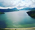
Looking south from above north shore of Lake Willoughby, with Mt. Pisgah distant left and Mount Hor distant right.
-
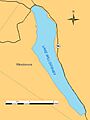
The lake is about 5 miles (8 km) long.
-
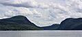
A view from the north end of the lake shows Mount Pisgah (left) and Mount Hor rising up above the surface.
