Mount Scott (Clackamas County, Oregon) facts for kids
Quick facts for kids Mount Scott |
|
|---|---|

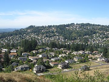
Southeast slope of Mount Scott, with the city of Happy Valley
|
|
| Highest point | |
| Elevation | 1,091 ft (333 m) NAVD 88 |
| Prominence | 745 ft (227 m) |
| Geography | |
| Parent range | Cascade Range |
| Topo map | USGS Gladstone |
| Geology | |
| Volcanic arc/belt | Boring Lava Field |
| Last eruption | 500,000 years ago |
Mount Scott is a cool natural landmark in Clackamas County, Oregon. It's actually a type of small volcano called a cinder cone. The top of Mount Scott reaches about 1,091 feet (333 meters) high.
This mountain is part of a larger area of ancient volcanoes known as the Boring Lava Field. This field includes many old volcanoes around the city of Portland. Mount Scott got its name from Harvey W. Scott, who was a famous newspaper editor in the 1800s and early 1900s for The Oregonian newspaper.
What is a Cinder Cone?
A cinder cone is the simplest type of volcano. It's usually a cone-shaped hill built from volcanic ash and small rocks. These rocks are called "cinders." When a cinder cone erupts, it throws out bubbly lava that cools quickly. This forms lightweight, porous rocks that pile up around the vent. This creates the cone shape you see.
Mount Scott last erupted about 500,000 years ago. This means it's considered an extinct volcano. It's not expected to erupt again.
Location and Surroundings
Mount Scott is located in a busy area. Much of its southern side is now part of the city of Happy Valley. This means homes and buildings are quite close to the mountain.
On the northeastern side of Mount Scott, you'll find the Willamette National Cemetery. This special place is a burial ground for military veterans. Part of this side of the mountain also extends into Multnomah County.
 | William Lucy |
 | Charles Hayes |
 | Cleveland Robinson |


