Mount Thayer facts for kids
Quick facts for kids Mount Thayer |
|
|---|---|

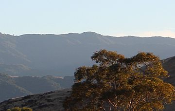
Mount Thayer viewed from Santa Teresa County Park
|
|
| Highest point | |
| Elevation | 3,479 ft (1,060 m) NAVD 88 |
| Geography | |
| Location | Santa Clara County, California, U.S. |
| Parent range | Santa Cruz Mountains |
| Topo map | USGS Los Gatos |
Mount Thayer is a mountain found in the Santa Cruz Mountains range in Santa Clara County, California. It stands tall at about 3,479 feet (1,060 meters) above sea level. The very top of the mountain is part of an area that used to be a military base.
Contents
What is Mount Thayer?
Mount Thayer is a natural landform that rises high above the surrounding area. It is part of a larger group of mountains called the Santa Cruz Mountains. These mountains stretch along the coast of California.
Where is Mount Thayer Located?
This mountain is located in Santa Clara County, which is in the state of California, U.S.. It sits about one mile west of another well-known mountain called Mount Umunhum. The Santa Cruz Mountains range where Mount Thayer is found runs through several counties in California.
What's Special About Mount Thayer's Summit?
The very top, or summit, of Mount Thayer has an old, unused building. This building is surrounded by telephone poles. The elevation of the summit is 3,479 feet. Elevation means how high something is above sea level.
Why Can't People Visit Mount Thayer?
The area around Mount Thayer, including its summit, is not open to the public. This is because the summit is located within a section of what used to be the Almaden Air Force Station. This was a military site in the past. For safety and security reasons, this land remains off limits to visitors.
Images for kids
 | Aurelia Browder |
 | Nannie Helen Burroughs |
 | Michelle Alexander |


