
Mount Umunhum facts for kids
Quick facts for kids Mount Umunhum |
|
|---|---|

Mount Umunhum from the southwest
|
|
| Highest point | |
| Elevation | 3,489 ft (1,063 m) NAVD 88 |
| Prominence | 586 ft (179 m) |
| Geography | |

Mount Umunhum
Location in California
|
|
| Location | Santa Clara County, California, United States |
| Parent range | Santa Cruz Mountains |
| Topo map | USGS Los Gatos |
| Geology | |
| Age of rock | Oligocene |
| Climbing | |
| Easiest route | Mount Umunhum Rd |
Mount Umunhum is a tall peak in California's Santa Cruz Mountains. Its name comes from the Ohlone people and means resting place of the hummingbird. It is the fourth-highest peak in this mountain range. The mountain is located in Santa Clara County, south of San Jose. People who live nearby sometimes call it Mount Um. Most of the mountain is part of the Sierra Azul Open Space Preserve.
Contents
How Mount Umunhum Formed
Mount Umunhum is made of a special type of rock formation. These rocks were once part of the oceanic crust and deep inside the Earth. Over millions of years, these rocks were pushed up to form the mountain. This process also caused the rocks to change. The northeast side of Mount Umunhum is one of the best places in the San Francisco Bay Area to see these unique rocks.
The Cold War Radar Tower
The very top of Mount Umunhum has a large, eight-and-a-half-story concrete radar tower. Locals often call it "the Cube" or "the Box." This tower was part of the Almaden Air Force Station. This station was a radar surveillance post that operated from 1958 to 1980.
Watching for Hostile Aircraft
The Cube was finished in 1962. It held a huge 85.5-ton radar system. This system was used to watch for enemy aircraft during the Cold War. The radar's signal was very strong. It caused electronic interference in radios, TVs, and sound systems up to 250 miles away every time it rotated.
Opening the Summit to Visitors
For a long time, the summit of Mount Umunhum was closed to the public. This was because of dangerous materials and unsafe buildings left from the old Air Force station.
Cleaning Up the Mountain
Plans were made to clean up the area and make it safe for people to visit. In 2009, with money from the government, the Midpeninsula Regional Open Space District started cleaning. They removed about 3,000 cubic yards of dangerous materials. These included lead paint, asbestos, and old fuel tanks. They also took apart 13,680 tons of concrete, asphalt, wood, and other materials.
Protecting the Cube
Even after the cleanup, the area around the Cube was closed again in 2018 for more work. Some people thought about tearing down the Cube. However, in May 2016, the Santa Clara County Board of Supervisors added it to the County Heritage Resource Inventory. This means the Cube is now a historic site and cannot be torn down.
New Trails and Facilities
On September 18, 2017, the road to the summit was finally opened. A new trail for mountain biking and hiking was also opened. Now, visitors can enjoy new paved roads, restrooms, and a small parking lot at the top. There are also signs that explain the mountain's history. The trail is part of the larger Bay Area Ridge Trail.
Native American Connection
In 2017, the Midpeninsula Regional Open Space District gave special permission to the Amah Mutsun Tribal Band. These are the descendants of the Ohlone Native American people. They lived in this area before Europeans arrived. This permission allows the band to build a special garden and hold important ceremonies on the mountaintop.
Weather Radar Station
Mount Umunhum is also home to the Bay Area NEXRAD weather radar. The mountain's high elevation is important for the radar to "see" across the region's varied landscape. However, being so high up can sometimes make it harder to detect storms that are lower in the atmosphere.
Images for kids
-
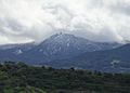
Mount Umunhum is dusted with snow a few times a year.
-
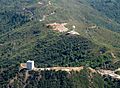
Aerial view from north
-
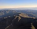
Aerial view, with Monterey Bay in the background
-
The abandoned radar tower and parking lot
-
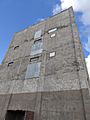
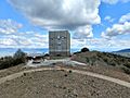
A close-up view of the abandoned radar tower


-
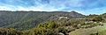
Mount Umunhum as seen from Bald Mountain
